Master Cartographer
April 2015 - Nov 21, 2024 8:06:11 GMT
|
Post by syzygy on Apr 27, 2016 13:11:45 GMT
Hi All! At the beginning this thread was about only one site I have spotted near a small hungarian settlement, then it quickly upgraded to larger scales, with many more markers all around the Carpathian basin. File name is already were Aerial archeology, later when collection contained sites also from distant locations, identified on satellite imagery as well, I have also changed thread subject to this more general. By this recent update when collection contains not only sites that I have identified on imagery, but by browsing GE Layer datasets, the time has come for another change. This work -though hard- I try to separate from my 'Burial mounds' and 'Prehistoric circular enclosures' collections, however some placemarks might sign this sort of earth feature. Some of the markers (e.g. Jadani triple ring, The king grave of sunghir or Arkaim) may have duplicate pairs from the oGEC forums, but I thought to include them as being important sites, also clearly visible on imagery. Here in proposal I must advise for all who interested to visit this archeology website by James Q. Jacobs, download kml content and check the biggest global placemark (and other kml features) collection of ancient sites I know. Order of updates:
Merged KMZ folder "Aerial archeology" is attached to this original post. Opening file you will find all the sites placemarked in this thread sorted into folders and subfolders.
Placemarks legend:- question mark and some 'red' placemarks to sign unidentified sites (even no info by GE Layers) / main purpose of this thread is to find out some about these!
- blue placemarks to sign sites with ID, based on GE Layer infos (Photo- and Community layers) or other other source and those have been solved by forum contributions
- misc. icon placemarks to sign other.(: ...finds by others, special items, etc.
Trench lines signed with pale, white line features. Last stage of updates are detailed in the everytime last replies. Turn on Photo- and GE layers for more credit on the locations!
Turn off outlines for better visibility of the features on imagery!------------------------------------------------------------- original opening post text body: Bronze Age Fortified Sites in the Carpathian BasinNo further information* yet about these interesting (one time) objects next to Medgyesegyháza remaining as clearly artificial soil pattern deviances with different surface color. (Amongst natural soil pattern features /watercourses of one-time smaller water flows/ these cannot be missed)
Right at the mark a double ring, cca. 500 meters NW to it other double walled linear structures can be seen. (trench/wall system) I have browsed through all historical maps and descriptions of the area, also have asked some locals, but no clues yet. However on homepage (hungarian) of the settlement editor states that the surrounding area were inhabited for at least a thousand years, 4 mounds (?), also 3 Árpád-age (1000 - 1301 AD) church ruins and numerous middle-age village remains were excavated; not a sign on old maps, not a word about exact location of a mound (kurgan) or any fortification around the site I could find yet. Now dear archeo-faces of GEC let's gather and say something! Thanks, g *EDIT: By this time it is clear that these on screenshot attached are Bronze-age fortified sites, parts of a defense network due to protect also main trade routes. According to a local archeologist, the northern trench/wall system is from the late-, the southern double ring (earthfort) is from the early- or middle bronze-age. (more details are coming on in thread below) Modified screenshot for the OP-site: 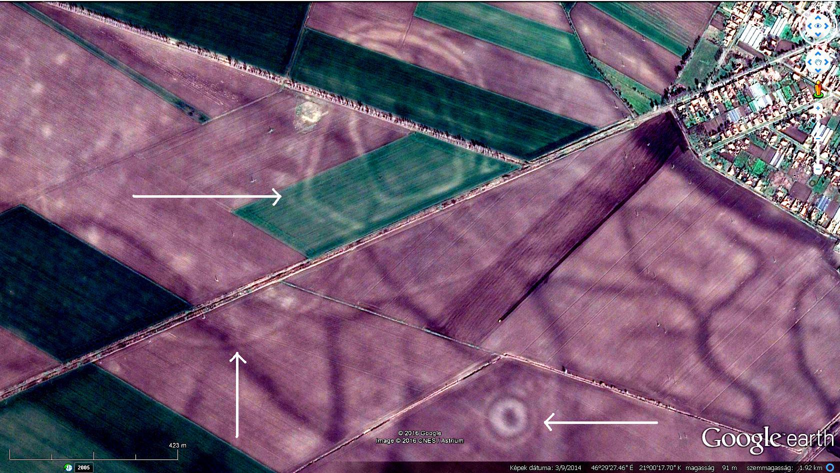 "All in One" kmz file attached:Aerial archaeology.kmz "All in One" kmz file attached:Aerial archaeology.kmz (127.82 KB) Attached kmz file only available here on the every-time "Live" GE Community Forums, which is now self-sponsored.If You make good use of this dataset, please donate our community! Thank You!
|
*** Related from board: all archaeo threads by archaeo, Related from oGEC: (Pain, all dead links!) Placemark-thousands of The Megalithic Portal guide to 25000+ ancient sites worldwide by Andy Megalithic, Historical Atlas of Eurasia by RWFG
Art of the steppe nomads by Villaman The frozen tombs of the Altai by Belizarius North American Archaeology 2013 by deansnow Some good source: megalithica.ruwww.megalithic.co.uk |
|
Full Member
Cartographer
May 2015 - Oct 21, 2024 18:35:52 GMT
“ Fellow Royal Canadian Geographical Society „
|
Post by jeanthie on May 2, 2016 1:37:11 GMT
Hi Syzygy, You marked an interesting archeological feature. At least it gave me the interest to look a bit at the remarkable history of Hungary and in particular the grasslands ecosystem. In your earlier post on Kurgans of Hungary, you already have provided a remarkable data base of ‘earth mounds’. But as you remarked this is quite different. Since the earthworks you found are visible through the soil colour primarily, sometimes vegetation enhances the structures, sometimes they disappear completely as the historical imagery shows. The soils in this area would mostly be Phaeozems (using the international classification) which have a dark, humus rich top layer- A-horizon, easily with a thickness of 50 cm (as result of the accumulation of organic material through the decomposition of the steppe grasses over time) over a light parent material. The thickness and colour of the A-horizon, may be important in the interpretation of the earthworks as the present surface topography of the earthworks only vary by centimeters and decimeters. Of course the farming in the last hundred years has had some impact. Not too far away, in a similar environmental setting I found a reference a Geophysical Survey at archaeological site Kaszaper, Békés County, Hungary by Peter Milo, László Lichtenstein, Zoltán Rózsa, Tomáš Tencer, Zoltán Fekete et MarekVlach.This could provide some hints for your site as there appear to be some similarities. Below is a picture of the Kaszaper site. I have added your own place mark for the Kurgan as well.  An example of their geophysical image: 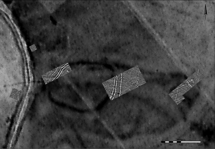 Their findings: This site was settled during the Bronze Age and Medieval Age. Dominant object is the stronghold dated in the Gáva culture (late Bronze Age). The stronghold covers an area about 240 by 280 m. The survey detects also large settlement activities from the medieval period. In the west part of stronghold there are traces of medieval church with cemetery, excavated in years1938 and 2003. They detected – ditch system from the Bronze Age and medieval Period, palisades, traces of settlements, pits, houses and maybe graves. In between this site and yours I also found this earth feature:  Just as a comparison to GE images for your site; below an image from Apple maps. In some areas it provides a clearer image in other areas, the double ring further away is not visible at all.  |
|
Master Cartographer
April 2015 - Nov 21, 2024 8:06:11 GMT
|
Post by syzygy on May 6, 2016 8:31:12 GMT
Whoa! This is something ever been called a quality reply, a perfect response on GE forums JT, master professor!(: I just did not look around well enough to find those. Thanks for the excellent searchwork and essential clues! (one addition: Szőlő-hegy /Grape-hill/ is only an alternative name of the mound by Kaszaper arceological site and probably better known as Templom-halom /Church-mound/ by locals)***
This recent find by me is probably nothing to do with the trench-duct-mound defence systems I think we are talking about even if not its old age. A 50 ms average width (double walled) linear feature as seen on sat/aerial imagery. Both endings are connected to existing channels which both are ancient water flows as well. It stretches 11 kms long from Reformátuskovácsháza, leads next to Tatársánc (Tatar trench) arceological site, turns 45 degrees to NE and goes along 8 kms near perfectly straight. Passes Nagybánhegyes and connects to another channel. From The First Military Survey (1763-1787) there is no sign of it on historical maps of Arcanum, so even if not ancient, must be rather old. Most likely it was a duct as well, connecting the two ancient waterflows. ***
Also notice 12 kms NW Kis- and Nagy-Tatársánc (Smal- and Big-Tatar trench) archeological site. (paste 46°30'7.27"N, 20°46'39.69"E to search panel on GE and zoom out a bit) From various sources (this one is hungarian so as wikipedia article) we know that since János Banner, researches proved: it is about Tatars only in its name, but the trench/duct/mound system was built by the Avars long before the Tatar invasions and is dated between the Late-Bronze- and Early-Iron Age, cca. 900-800 BC* in defence of Schytian and/or Celtic attacks. (*The memorial stone at the site /Panoramio shot available/ and first source above dates the built as VIII-V. century BC)main-step partial scales look similar to "our" objects. Maybe these were already studied (only my "armchair exploration" was not exhaustive enough), maybe not. One thing I am sure now: we found something artificial that really old. Some History Illustrated as paintings on the canvas of Earth's surface. *** The time has come I made a merged KMZ folder, named "Aerial archeology" and attached it to the original post. Opening file you will find all the sites placemarked in this thread sorted into folders and subfolders. By this contribution I have added this site (mark and outline) in subfolder: "linear structure, Nagybánhegyes"Turn on Photo- and GE layers for more credit on the locations. (and turn off line kml for better visibility of the feature on imagery) 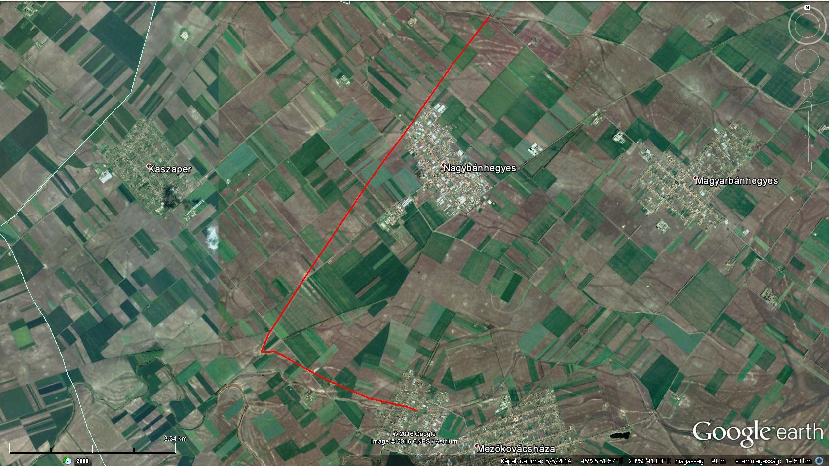 |
|
March 2015 - May 1, 2023 4:20:37 GMT
|
Post by diane9247 on May 17, 2016 4:54:19 GMT
A superb thread, gentlemen! Those are indeed interesting features and impressive research by both of you.
|
|
Junior Member
May 2016 - May 13, 2016 14:49:27 GMT
|
Post by filsdabeille on May 17, 2016 7:06:49 GMT
There are many such places in UK. ... it's 2031 km ( 2000 km with 1,5% error) from Kheops, at 30° angle. (ATan (1/√3)
I wouldn' be surprised if...
... Please see attached kmz and jpeg.
There's definitely remains of ancient activity. If you take the ring as starting point, and point to Kheops, you'll get a 151° angle direction. Below a path extends 7200 m along that direction defining a circle centered 3600 m from beginning of path. The 3600 m radius and angle are important attributes highlighting the geometric importance, and possible reality, of that particular path stretch, because the subsequent relationships yield interesting results and relate to Kheops (this is not a fantassy, many others do, and far more convincing than present case) The resulting geometry figure is interestingly meaningfull, and several interceptions with roads (old pathways) and land délimitations (these are inherited from gen to gen) consolidate the reality of the figure. 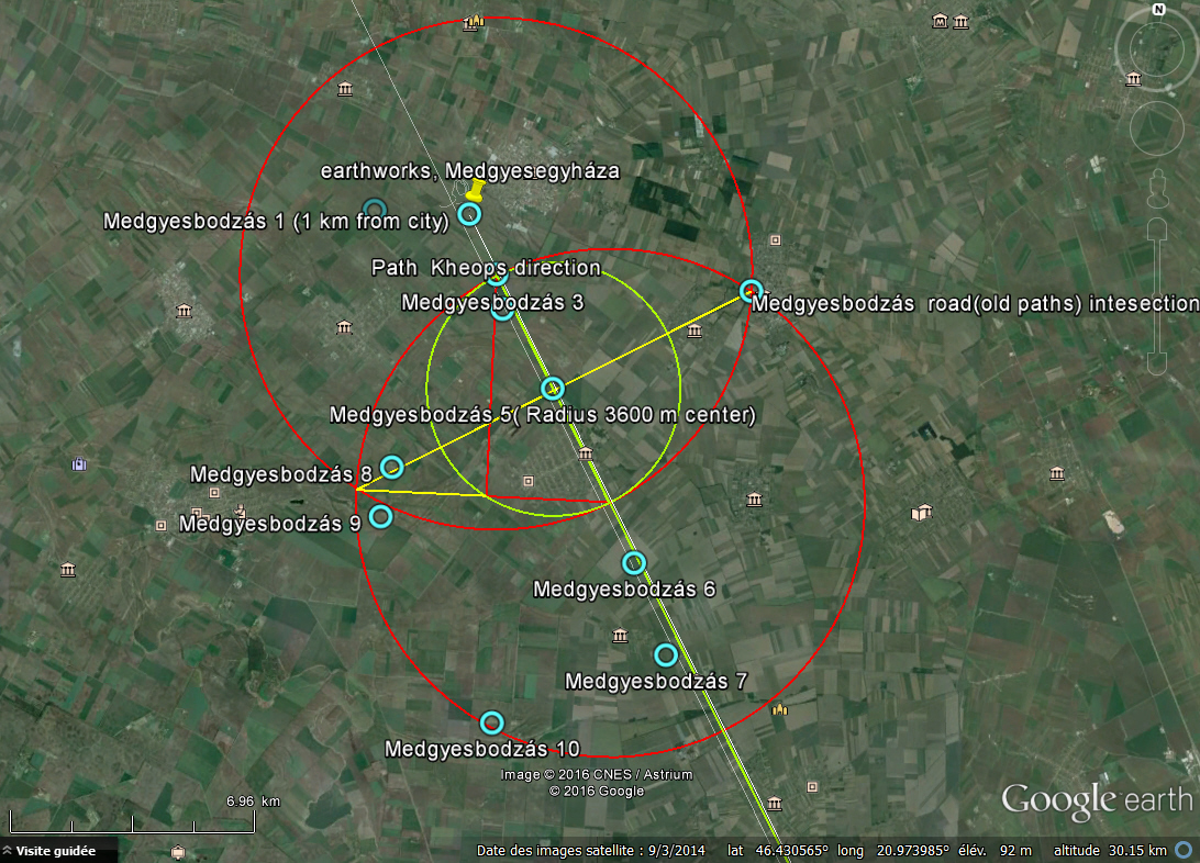
Now it may all be stemmed from my imagination, because no other relevant source of information available (at this point), but am 50% sure the diagram not random.
History, Rome amongst others, has erased most significant attributes, so we only have what the earth has to say... and it says enougth worth further digging into...  Cheers, feedback wellcommed  Attachments:Medgyesbodzs.kmz (13.85 KB)
|
|
Master Cartographer
April 2015 - Nov 21, 2024 8:06:11 GMT
|
Post by syzygy on May 19, 2016 7:24:21 GMT
Hi and welcome to this community babyboybee!(: (sorry, am I wrong with your nick filsdabeille?) Thanks for the interesting response and valuable new marks of your new "suspicious" findings! I have to confess, I have ever been bad at maths, so sorry if I miss the "beauty" of equations of numbers and greek letters, you mathscholars mention often so excited. But keep your chin up! This is the very best place where you have good chanches to bump into "learned-friens" who will appreciate your calculations well! One is for sure: following your sketch other ancient sites can be find. I was especially glad to find again THIS one at 46° 0'1.07"N, 21°21'35.43"E*** One piece of advice: more patience around here! You have just registered few days ago, but in some of your threads I feel you upset that you have not received a reply so far. Your threads are "meaty" even for a mathematic, do not talk about me! Try to pay more attention to the landmarks on GE you find with your method than to formulae and your posts might turn more "digestible" for a wider public. Now I do not talk about your 'paralell lines' finding, which one is simply so odd that no one have any ideas yet. -We have to wait for the answer and might propose other questions meanwhile. Sometimes months are passing until a good response done, but I think it is better to receive a valuable reply later, than a "hmm.." or "whoa!" instantly. "Good piece of work presumes enough amount of time" -we say here in Hungary. Keep up the good work! Best, g |
|
Master Cartographer
April 2015 - Nov 21, 2024 8:06:11 GMT
|
Post by syzygy on Jun 16, 2016 10:17:02 GMT
...and finally! Check this article.pdf (eng) from 2013 autumn on hungarianarchaeology.hu (eng) e-journal page! The other great source I have used is z-studarch.ro (eng), another sort of Archeological journal, exactly this article.pdf (eng) from 26.1.2012. Updated KMZ attached to original post. By this contribution I have added 7 more sites in subfolder: "miscellaneous earthworks"Best, g |
|
Master Cartographer
April 2015 - Nov 21, 2024 8:06:11 GMT
|
Post by syzygy on Jul 27, 2016 12:24:10 GMT
Have just updated KMZ attached to the original posting. Some further linear structures, two suspicious sites and the most interesting: another double ring structure next to Billéd with the same size-parameters of the one by Medgyesegyháza. (well photo-layered mound /Kálvária-domb/ WSW to it) You will find these sites in the "recent updates/2016.07.27." subfolder. (open as default)  45°52'36.20"N, 20°59'16.82"E 45°52'36.20"N, 20°59'16.82"E |
|
Master Cartographer
April 2015 - Nov 21, 2024 8:06:11 GMT
|
Post by syzygy on Feb 17, 2017 11:33:51 GMT
In this update you will find several new sites I have spotted recently: Most interesting ones are can be find in ' Khazaria' subfolder, but nice examples have been added also to the 'Carpathian basin' group. (one duplicate here: The Jadani Triple Circle) (Signed features in firstly mentioned group of sites might nothing to do with Khazars, only I have named folder after the one-time territory of their Khaganate.) Ending you will find an 'other sites' folder, where I have put two other duplicates from oGEC I have thought important to be included. (The only one overlay of this update for the Arkaim site is off as default view.) Please read my edited proposal for this thread and download updated kmz from original post! *** Some examples (open questions / unidentified sites) from this update I have found most interesting:***
Clearly visible two circle with 1,5-2 km diameters and several other suspicious circular pattern - Russia: Archeo expert acquaintance warned me that these* are marks of standing water (*plural as another similar structure with smaller scales have been found since - check UPDATE 2017.MAR.02.), still I let it here and kmz as well, supplemented with the water stand option.  52°46'12.29"N, 48°35'16.74"E 52°46'12.29"N, 48°35'16.74"EHave already checked some archeo maps from wikipedia and other sources, but no relevant info on this particular site. Khazars, Volga Bolgars, Pechenegs and who knows how many more nations of history settled there for shorter or longer periods. No layer info. - Opinions welcome! *** 75+ km long linear earth feature - Russia. With that number of turns and zig-zag must not been road or canal, some kind of defense line would be my best guess. Maybe not as ancient - probably some WW trenches?  47°38'52.64"N, 39°19'14.27"E 47°38'52.64"N, 39°19'14.27"ENo layer info. Any help would be great!*** and two other examples - earthwork-footprints from the Great Hungarian Plain:  . 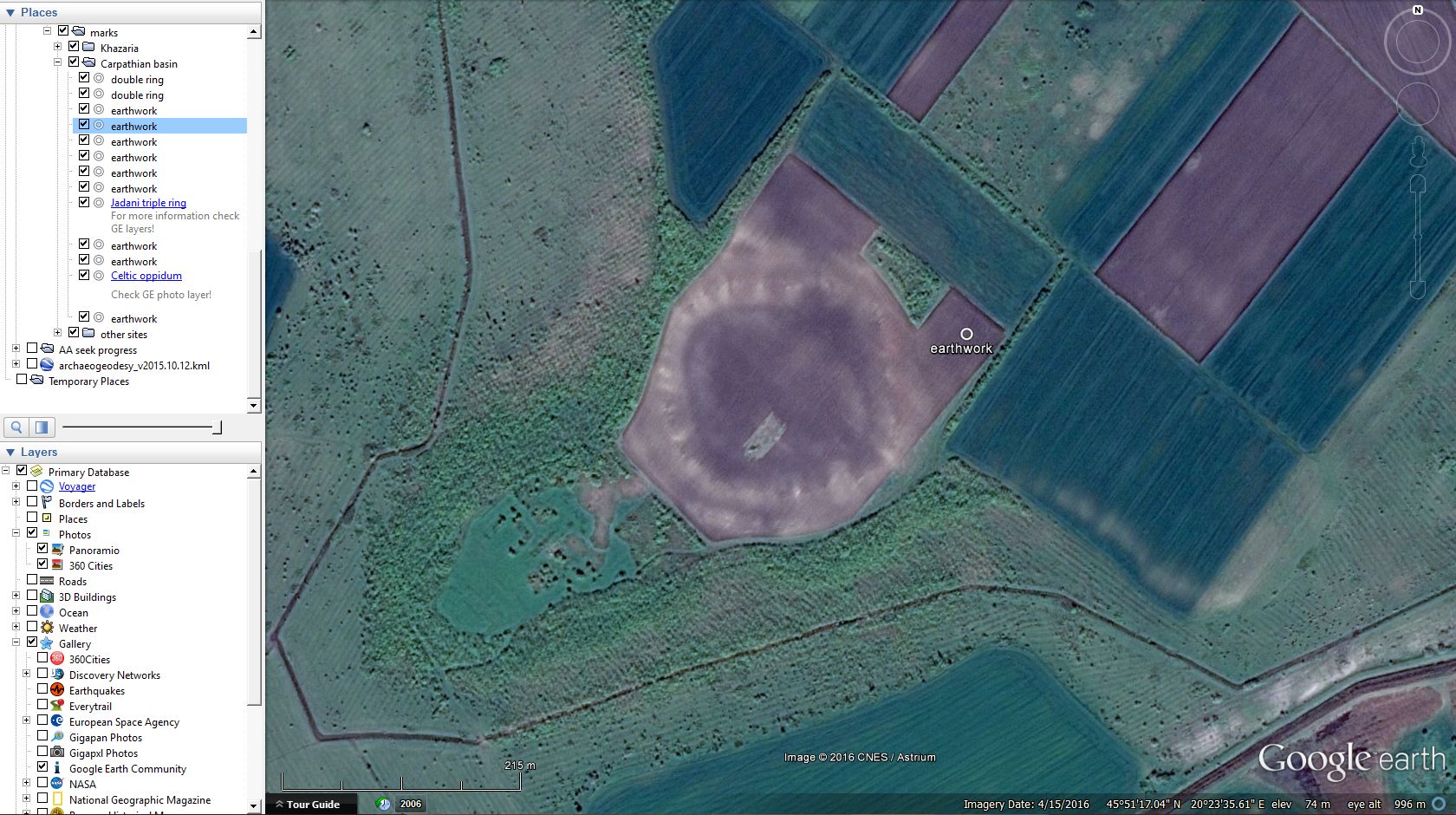 No layer info, but I think we can keep our point of view about these. |
|
Master Cartographer
April 2015 - Nov 21, 2024 8:06:11 GMT
|
Post by syzygy on Mar 2, 2017 13:22:22 GMT
In this update -amongst many known, but not placemarked sites- I share some new findings of mine with no further information so far. (New update feature that I leave my open questions' sites marked with red, also sorted sites in " known sites" and " new findings - no info" subfolders.) The one -and most interesting- I give as an example here is the "Ukrainian small-brother" of the tangential earthwork circles in Russia I have found by last update. Same shape and arrangement, only these are much smaller: Archeo expert acquaintance warned me that these are marks of standing water, still I let it here and kmz as well, supplemented with the water stand option.  49°19'26.08"N, 31°52'10.12"E - Opinions welcome! 49°19'26.08"N, 31°52'10.12"E - Opinions welcome!*** Another earth feature I have marked with lines (lines/trench lines subfolder) are possible signs of (WW?) trench lines, only some further info needed about the age. (Just as the ones in last update, these are long distance zig-zag lines so road or chanel solutions can be discarded also in this case.)  I give no coordinates, check mentioned subfolder! - Any info would be great to close this "zig-zag-lines question" at last! *** After downloading file you will find only this recent update's folder checked and opened with many more sites included. (!)All features (sites) in line-folder (except the ones in the trench lines subfolder) are having also placemarks set to different imagery timestamps, so only you have to doubleclick to each for best aerial visibility. Download updated kmz from original post! |
|
Master Cartographer
April 2015 - Nov 21, 2024 8:06:11 GMT
|
Post by syzygy on Apr 5, 2017 9:26:00 GMT
Hi! For my first find, topic-starter two earth features at Medgyesegyháza I have recently got some, a bit more detailed informations, given by local archeologist. They did a field work with the Munkácsy Museum and ascertained that the northern trench/wall system is from the late-, the southern double ring (earthfort) is from the early- or middle bronze-age. Now in reply I will ask whether these could be related to a particular group of people, to an exact nation or culture. *** By this update, besides 11 new findings at issue and some other (WW?) trench sections, 4 identified sites (as Boyarskaya petroglyphs, Uzenhyr archaeological site, Saigachiy mine and a Roman rampart) also can be find in recent subfolder. (From this date, blue qestion-mark placemarks in 'unidentified features' subfolder are to sign remaining questions of this thread.) Opinions for all marked sites in question and any additional info on identified sites welcome!Two picks from this update:
example 1: /from unidentified features subfolder/ 45°53'39.17"N, 20°55'15.68"EDouble linear structure near Billéd (where other double-ring feature had been marked by a previous update) have been spotted, marked and outlined with help of different imagery on HERE Maps. example 2: /from identified sites subfolder/ 53°55'59.01"N, 91°16'43.06"E Uzenhyr archaeological site. Firstly have spotted structure on Google-Earth imagery and have found site name and photos using GE photo layer, then some description on russian language by a Google-Search, ending, have given Google-Translated text to placemark balloon. ...well it seems, Google Corp. had something to do with that again...(: Download updated kmz from original post! best, g |
|
Master Cartographer
April 2015 - Nov 21, 2024 8:06:11 GMT
|
Post by syzygy on Jul 14, 2017 11:44:19 GMT
Hi! 16 scenes from Bulgaria, Ukraine, Romania and Russia in this update (the only subfolder opened and checked after kmz downloaded): 4 sites we know, based on GE Layer contents (Great photos! Check GE Photo Layer!): - Turda Fort 44°57'35.31"N, 28°38'35.23"E ,
- Pliska Megaliths 43°21'5.02"N, 27° 8'16.31"E ,
- Unknown ancient town near Royak, 43° 5'53.33"N, 27°21'44.67"E and a
- Thracian Cult Complex 41°22'54.90"N, 25°13'22.97"E .
9 unidentified sites, also spotted browsing GE surface, but no reference in GE Layers, and 3 sections of probable trench lines. Download updated kmz from original post! Best! g |
|
Master Cartographer
April 2015 - Nov 21, 2024 8:06:11 GMT
|
Post by syzygy on Nov 29, 2017 13:21:56 GMT
been away for a while, many more archaeo locations in last update's folder, but the real reason why I post now is my latest find: ancient stone sculptures - steppe idols- in the backyard of a village house!photo misplaced so would be hard to find out, which house it is in the nearby settlement, still the fact shocks me, that invaluable, ancient artifacts can be seen in such conditions:  Panoramio shot by Flazz Panoramio shot by Flazz / 49°58'21.51"N, 88°11'4.65"E hope, only some local museum is just about to bring these into proper circumstances... (to tell the truth: I do not think so...) ------------------------------------ two more picks, special update's favorites of mine: one more earth ring feature from the Carpathian basin similar to my first find I has been spotted near a small settlement with talkative name: Szentkozmadombja (Mound of St. Cosmas)  46°41'4.35"N, 16°46'18.48"E and another one from Russia  45°25'21.72"N, 41°33'28.86"E -------------------------------------------------------------- 3 folders you can find in this update's subfolder: 23 sites we know, based on GE Layer contents (mainly photos) and other sources, 7 unidentified sites, also spotted browsing GE surface, but no reference in GE Layers can be find, and 3 sections of probable trench lines. Countries involved with update: Hungary, Serbia, Ukraine, Russia, China, Peru. Download updated kmz from original post! Best! g |
|
Master Cartographer
April 2015 - Nov 21, 2024 8:06:11 GMT
|
Post by syzygy on Feb 7, 2018 13:21:23 GMT
By this update 13 sites with some ID and 5 sites with no further info enabled by opening kmz file attached to original post! *** Where I would need your help or opinion, the 3 most exciting sites for me with no further info yet are these below: 1. gigantic earthen structure in NorthEastern Afghanistan: FULL IMAGE2. ancient looking fort in Northern Turkmenistan: FULL IMAGE2. ancient looking fort in Northern Turkmenistan: (subfolder contains 2 more marks from the same location: 1 for another fort-structure and another for something I am not sure whether can be natural formation's or some artificial foundations' structure) 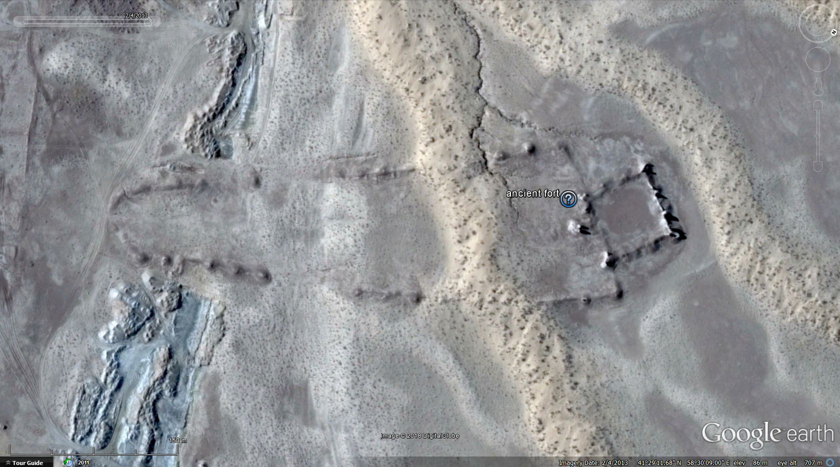 FULL IMAGE3. FULL IMAGE3. half a dozen placemarks for probably not that ancient forts from Afghanistan again, only by this time from the SouthWestern deserts (one example better resolution BingMaps screenie): 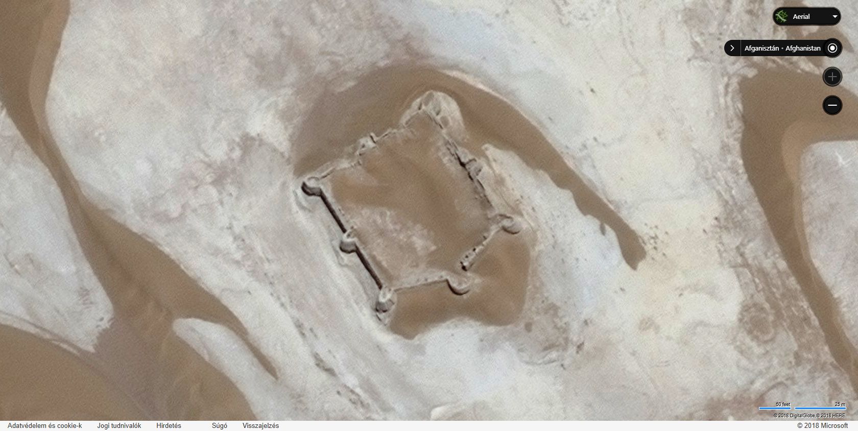 FULL IMAGE FULL IMAGEthanks for attention and help in advance! g |
|
Master Cartographer
April 2015 - Nov 21, 2024 8:06:11 GMT
|
Post by syzygy on May 10, 2018 13:50:02 GMT
new kmz folder structure let you see all my questions by one click:  also 9 "no-info" and 18 identified sites included in this update. Updated kmz file attached to OP. |
|
Master Cartographer
April 2015 - Nov 21, 2024 8:06:11 GMT
|
Post by syzygy on Apr 18, 2019 21:16:10 GMT
new markers of this update sign locations of circular soil- or cropmarks (in company of a gratis 3D structure), a bunch of bronze-age sites from Hungary and many more - known (29) and unknown (20) as well. my special favorite "own discovery" site of this update is a rondel(?) trio from Ukraine:  I have already searched through days to find something about these with no success ... even for an opinion I would be very grateful! there are some objects with source, suspicious to be neolith rondels:  (GE screenie with auto contrast) (GE screenie with auto contrast)and further own spottings, that might be related:  BingMaps screenie (with auto contrast) BingMaps screenie (with auto contrast)This update also contains some quite big enclosures (with other features within) from Vojvodina:  this one -the bigger- is 1 kilometer indiameter (!) kmz file, updated with many questions (red circle marks) and some info-spots (white) attached to OP. |
|
Master Cartographer
April 2015 - Nov 21, 2024 8:06:11 GMT
|
Post by syzygy on Apr 6, 2021 10:49:58 GMT
Quite bigger update with a new selection kmz subfolder for ancient rectangular fundaments from the Far East -green markers for most complex structures
-blue markers for sites with some further infoSome examples:Kara Khoto ruins, China:  King Khara-Khul ruins King Khara-Khul ruins, Mongolia:  Ulanbay ancient city Ulanbay ancient city, Western China:  Ruins of 'unknown' gigantic, rectangular multistructure Ruins of 'unknown' gigantic, rectangular multistructure, Northeastern China:  Por Bajin Por Bajin, Russia:  and various other artificial patterns of ancient human presence, e.g. this one from Mongolia:  Placemarks for 50+ such ruins sites Placemarks for 50+ such ruins sites also another new subfolder for Bronze-age fortified sites from the Carpathian basin with 70 placemarks and many line features are available by this update. All-in-One kmz file attached to OP. |
|
Master Cartographer
April 2015 - Nov 21, 2024 8:06:11 GMT
|
Post by syzygy on Feb 29, 2024 9:36:56 GMT
A long awaited (minor) update just has been done.
18 identified- and 10 unidentified sites added.
Countries affected by this update are:
China, Kazakhstan, Kyrgyzstan, Turkmenistan, Afghanistan, Iraq, Mali, Argentina, Boliva, Chile and Canada.
--
Updated kmz file attached to Original Post!
|
|
Master Cartographer
April 2015 - Nov 21, 2024 8:06:11 GMT
|
Post by syzygy on May 15, 2024 10:27:15 GMT
Major updates on Serbia, Romania, Mongolia, Afghanistan, Uzbekistan, Turkmenistan, China and Peru also a few more placemarks from Kazakhstan and the USA. 34 identified*- and 16 unidentified sites added. *3 bigger folders included: 50 placemarks just below the Aral Sea are representing most of the fort ruins of the ancient Chorezm, and another 160+ marks for all the historical citadels and other ruins in Nimroz, Afghanistan I could find. Useful links to valuable sources are given in kmz content.   (click to enlarge images) A 3rd subfolder contains placemark set for 10 ancient beacon tower ruins from China and 1 more from Mongolia. -- You can download updated kmz file attached to Original Post! |
|


 .
.


