Junior Member
September 2021 - Sept 23, 2024 14:04:01 GMT
|
Post by buildsancient on Oct 1, 2021 11:42:14 GMT
Well, hello there! My first post here! I thought I would butter you all up by giving you something nice to play with. This represents the work done by Micheal E. Davias on the formation of the Carolina Bays. Here is a link to a YouTube video by Antonio Zamora explaining how it all works. It really is quite startling if you are new to the topic. It also doubles as an extremely useful tool to help you find mounds in the USA! I have found dozens of them. I usually email the local University for more info, and they are oftentimes quite happy to reply. I understand that this should probably be in the tools thread, but where's the fun in that? In this case, I think this deserves better coverage and discussion. CbaySurveyLink 5.kmz (985 B) Here's some nice mounds I found: First is on private land, and is being monitored closely. Landowner has been suitably chastised for digging into it. He won't let any excavation happen though. Second has never been properly researched. It is known as 4 mile mound, and is in a hard to reach location. Enjoy! First is located at: 31°49'15.44"N 91°47'48.83"W and the second at: 32°13'27.23"N 90°43'11.70"W The first bears a remarkable similarity to Watson Break.   |
|
Master Cartographer
April 2015 - Nov 24, 2024 16:27:49 GMT
|
Post by syzygy on Oct 1, 2021 21:39:48 GMT
Hi and welcome on the board! Thanks for very interesting stuff on Carolina Bays and beyond! Sure I add this to my list of useful web map tools! Your individual mound spottings look promising for a discussion here on Cultures sub-forum, but it won't work unless you give locations. Until that others don't have the opportunity to make their own research, which would make them able to discuss anything about the sites. Hope that it can be fixed, because until you won't give coordinates- or attach kmz file for the mounds, really this thread better fits Tools section. Sincerely hope I can check your mounds locations on GE for myself! Regards - G |
|
Junior Member
September 2021 - Sept 23, 2024 14:04:01 GMT
|
Post by buildsancient on Oct 2, 2021 10:36:26 GMT
Done!
|
|
Master Cartographer
April 2015 - Nov 24, 2024 16:27:49 GMT
|
Post by syzygy on Oct 2, 2021 21:21:44 GMT
Thanks! However cannot check on desktop GE at the moment only on web GE on my phone, still sure these are real 3D structures as even tree canopy can not hide them. Much thanks both for sharing your very nice finds and such a remarkable Lidar tool! (That kmz rocks!) Similarity with Watson break cannot be missed and that 4 mile mound... is not a pyramid instead...?! ( ; Rather interesting structures anyhow! Please keep us informed if anything happen to come up about them! Hope I'll have some time next week to have a deeper look myself! (Also just thought whether if archaeo or jeanthie would be interested..?) ... See You! G |
|
Junior Member
September 2021 - Sept 23, 2024 14:04:01 GMT
|
Post by buildsancient on Oct 3, 2021 8:56:13 GMT
I actually got pretty bored finding mounds over there. They are everywhere. Three sided pyramids are pretty common too. The trick is too look on flat river plains where rivers converge.
They liked building there.
Regarding Canada, it's a bit trickier. But there is a LOT of stuff around Ontario. And some very suspicious Irish looking stone circles too? Once you get up to New England, there are hundreds of thousands of km of stone walls, cellars and dolmens too. Burials with red ochre. Check up on the red paint people.
You will need to download the LAZ files from the Canadian government portal.
|
|
Full Member
November 2015 - Nov 27, 2015 21:55:18 GMT
|
Post by archaeo on Oct 4, 2021 14:45:22 GMT
Thanks for the interesting post.
I'm back on board after years of not checking in. Activity here had been quite minimal. Thanks for tagging me here syzygy, I got an e-mail alert.
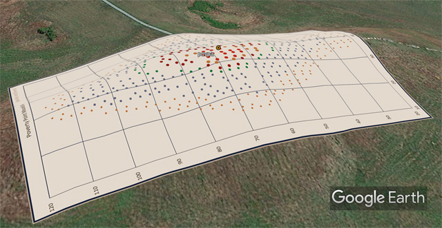
I recently worked with LiDAR for Poverty Point and used the raw DEM data to create cloud point scatter plot overlay images. That KML file is posted in a 2021.03.14 (Pi Day) entry in my ArchaeoBlog.
Using the Louisiana state's LiDAR data I was finally able to update my Watson Brake positional data. Using the data demonstrated that Google Earth is using the LiDAR DEM data (about 1m resolution) for their elevation modelling. Good to know their accuracy is that refined in this region. I was accustomed to 75m DEM modeling in the Andes.
Well, that's my news and the links you need to update KMLs. Of interest here, there is another mound near the first one mentioned above, Alexander Mound, 31.823254 -91.815798. I have a lot of other mounds nearby placemarked.
Just looking around these two a bit with the KMZ turned on, I notice a large platform at Fitzhugh Mounds, 32.321036 -91.084627, I had not noticed or placemarked before. In satellite view it is a plot of trees. Also, the river front appears to have had a series of residential platforms??
Enough for now. Thanks for posting this very useful tool. I'll give this more attention when I "return from France" so to speak.
|
|
Junior Member
September 2021 - Sept 23, 2024 14:04:01 GMT
|
Post by buildsancient on Oct 5, 2021 7:22:04 GMT
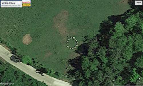
Thanks! Just checking out your site. Great work on the KMZ. apps.nationalmap.gov/3depdem/ is a one shot place to download Liddy for the US. That said, the guys down at LSU are a nice bunch and are happy to answer any questions you might have. Regarding Poverty Point, I dunno. I get the feeling that half of it washed away... At least it does a good impression of it. There is lots of stuff in Canada too. Check out this Stone Circle:  My friend Steve found that one. He also has a pyramid built out of quartz on his property? If you are interested, he also rents out cabins if you fancy a break. Link. |
|
Full Member
November 2015 - Nov 27, 2015 21:55:18 GMT
|
Post by archaeo on Oct 5, 2021 13:56:15 GMT
|
|
Master Cartographer
April 2015 - Nov 24, 2024 16:27:49 GMT
|
Post by syzygy on Oct 5, 2021 14:17:25 GMT
Hello James! So glad my call has reached to you! Thanks for kind comments and updated links - basic and essential kmz stuffz if GE archaeology! ( ; ...Activity here had been quite minimal.... Probably it is true for your threads, but not for mine... Here some, more or less related threads of mine you may have missed while been away: *** Ancient African Stone Structures (3545 placemarks) / 85 interesting " new structures" I am about to get to know something exact. My Eurasian burial mounds collection now is up to 27.852 placemarks with my first own, real discovery of a Sarmathian, ring-ditched, mini-kurgan cemetery from my county. (No one have known about it before - studies on their ways... No archaeology, but interesting historical (french!) african colonial aviation landmarks thread with 25 landmark sites (and prominent members). My updated Aerial Archaeology collection with new subfolder of bronze-age fortified sites from the Carpathian Basin. Ending my collection of Neolithic Circular Enclosures (rondels) from Europe. With overlays in many cases now is up to 164 placemarks and 34 overlays for sites from 15 countries. *** All the best and keep up the good work! G |
|


