Master Cartographer
April 2015 - Nov 21, 2024 8:06:11 GMT
|
Post by syzygy on Oct 2, 2018 13:51:41 GMT
To make pair of my saudi collection as Ken Grok did with his perfectly done oGEC posting; Neolithic Monuments of the Sahara (erased by Google in 2019), let me share here my additions from the vast african deserts. By this first update kmz folder contains some 90+ placemarks around Aorounga crater, Chad; mostly burial sites (mounds, mound chains and -groups) and two other types of stone features: "irregulars" and "kites" to follow Ken's nomenclature. (note: by last update such features mapped only in Saudi-Arabia by Ken.) Primary collections by Ken Grok (492 placemarks) now included in subfolder: Neolithic Monuments of the SaharaRecent stage of updates: 3588 placemarks all together - kmz subfolders for Mauritania, Mali, Niger, Western Sahara, Algeria, Chad, Libya, Ethiopia and Morocco. KMZ download: >>> Ancient African Stone Structures.kmz (284.29 KB) Important note of the editor:All the ZoomEarth links you find in this forum thread and in kmz content are now outdated. - Slowly but steady I change all to BingMaps links ... ____________________________________________________________ Related from the Web:Sahara Overland by Chriss Scott - (Thanks professional assistance for chriss and tafrawti!) Western Sahara Project - Photo documentation by Nick Brooks researchgate.net/The_Archaeology_of_Western_Sahararesearchgate.net/A_regional_perspective_The_surveys papers.ssrn.com landbeforetime.home.blogsteemit.com/antonytunstall/eyes-of-saharaalgerie.voyage.over-blog.comgeolines.ru/sahara-geoglyphs* Related from board: Ancient Saudi Stone StructuresSaudi stone-wheel geoglyphs (subfolder of this post's kmz attachment shares the same name now) "Have I found an archaeological site?"Ancient Megalith With Laser Cut? by CuriousJM Prehistoric circular enclosuresPrehistoric Enclosured SettlementsMy archaeology collectionMounds of (the) Earthall archaeo threads by archaeo, * Related from oGEC: (erased by Google in 2019) Placemark-thousands of The Megalithic Portal guide to 25000+ ancient sites worldwide by Andy Megalithic, Neolithic sites in Arabia and East Africa by KenGrok Neolithic Monuments of the Sahara by KenGrok Historical Atlas of Eurasia by RWFG
Art of the steppe nomads by Villaman The frozen tombs of the Altai by Belizarius North American Archaeology 2013 by deansnow |
|
Master Cartographer
April 2015 - Nov 21, 2024 8:06:11 GMT
|
Post by syzygy on Nov 28, 2019 9:20:58 GMT
Thanks new member, Bryan and his exercise posted on some linear features in Mauritania, I have made a look around and easily could manage to set up a new folder for this thread. Ancient settled sites, sacred places with mound cemeteries and various other walls, tracks and lines of stones all around where desert-sand meets the rocks. Two example screenshots of my special favorite sites from this update: Gathering around the Sacred Stone: Great aerial photo HERE! Crowded Downtown: updated kmz attached to OP. |
|
Master Cartographer
April 2015 - Nov 21, 2024 8:06:11 GMT
|
Post by syzygy on Dec 4, 2019 14:39:14 GMT
Many more placemarks since last update - Richat structure has been mapped (for a first look around) for example: 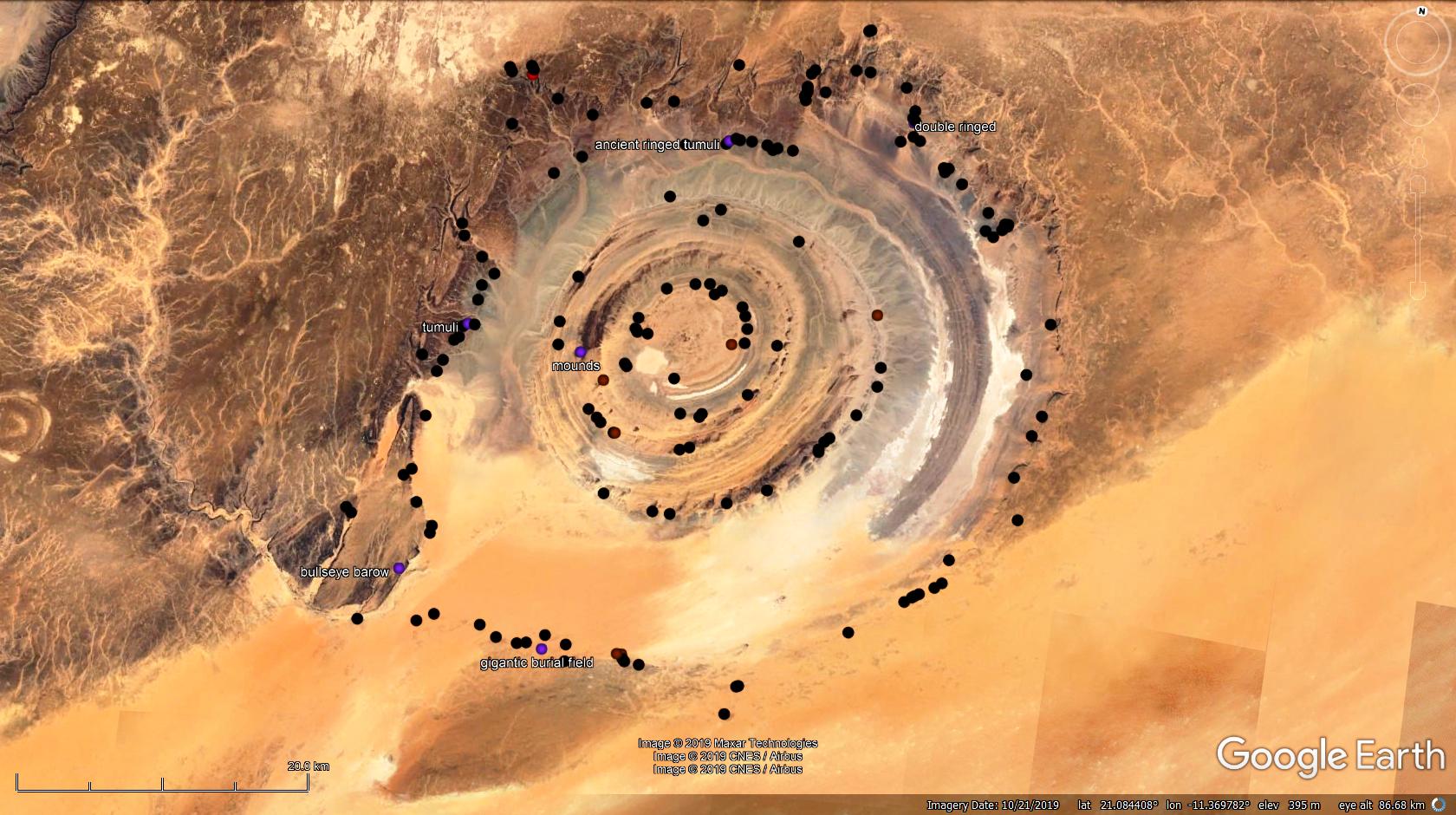 Map looks like a kind, happy, little piggy...(: Also please check this Bing Maps link for the most complex structures and burial site I have ever spotted on maps!  *** Other oddity from around - "Alien sign" buried under crescentric dunes of Mauritania, posted here on EB subboard: 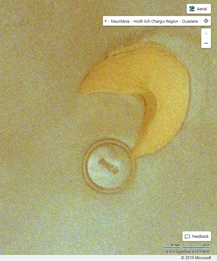 updated kmz attached to OP. |
|
Master Cartographer
April 2015 - Nov 21, 2024 8:06:11 GMT
|
Post by syzygy on Feb 1, 2020 21:10:46 GMT
Hi everyone! From latest update on Mali I would like to highlight a (burial?) site complex that never been discussed before around GEC. At this point of mapping it stretches across some 40 kilometers (and rising), really in the midlle of the barren nothing.. Sometimes as if these were gigantic cupmarks carved into solid rock, sometimes as small, natural rock outcrops and sometimes as "simple" clusters and chains of burial mounds. Some examples:[slide captionposition="1" wrapperstyle="padding:10px 0;border-top:2px solid #eee;border-bottom:2px solid #eee;"]https://res.cloudinary.com/syzygy/image/upload/v1580590436/mounds/sc.mali1.jpg A res.cloudinary.com/syzygy/image/upload/v1580590437/mounds/sc.mali2.jpgB res.cloudinary.com/syzygy/image/upload/v1580590437/mounds/sc.mali6.jpgC[/slide] Ending two more: a chain and clusters. (image links) Since have found I dub these "suction cups". - Anyone with any further- or some more exact explanations? *** (Updated kmz file attached to OP.) |
|
Master Cartographer
April 2015 - Nov 21, 2024 8:06:11 GMT
|
Post by syzygy on Feb 9, 2020 18:08:33 GMT
yeah, quite often it seems I bump this thread of mine, but this time I really have the reason why. - two important reasons I have exactly: 1.: my own collection has passed the 1000th placemark 2.: my interests (burial mounds) literally have met Ken's at this point of search: Burial mound in the middle of a so called "crescent" geoglyph from Morocco:  updated kmz file attached to OP. |
|
Master Cartographer
April 2015 - Nov 21, 2024 8:06:11 GMT
|
Post by syzygy on Feb 21, 2020 12:06:50 GMT
Hi everyone! Update reply because of a new kind of structures, I have spotted in Mali and later in Algeria, browsing better resolution imagery on ZoomEarth. Enclosed stone structures made up of "small" (20 meters) arches and some burial mounds around the spots:  >>21.775129, -0.087676<< ZoomEarth link >> 4 more such "lacy rondel" selected into "Best picks" folder for Mali. << 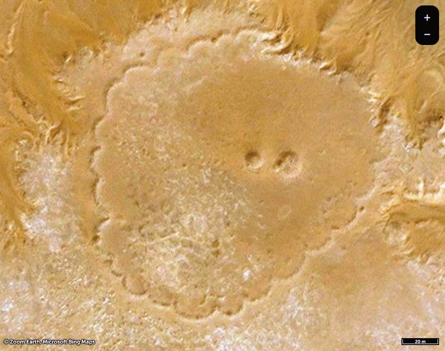 #  # 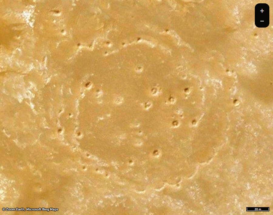 #  Links to full images of these as # rondel2 # rondel3 # rondel4 # rondel5 # okay, this latter with that beautiful double lacy pattern deserves an instant bigger view and ZoomEarth link as well...(:  ***edit: Also I add this one, that blew my mind with that strange "neighbor". I have just spotted on ZoomEarth, however now it is quite better on GE:  GMaps link GMaps link(Meanwhile many more "rondels" have been placemarked from Mali and Algeria. - Search purple-star placemarks in the collection for this kind of structures.) *** Interesting, some of the neolithic and chalcolithic-age rondels from Portugal(!) are show similar patterns. Check e.g. inner circle of the one at Salvada:  (Above view only available on historical imagery of desktop Google Earth) The all, you got to know about these at portugueseenclosures.blogspot.comAlso dimensions seem to fit: cca. 20 meters for arches' diameters by both structures and huge, 250 and 300 meters for the enclosures' diameters. (!) *** Updated kmz folder attached to Original Post. |
|
Master Cartographer
April 2015 - Nov 21, 2024 8:06:11 GMT
|
Post by syzygy on Mar 16, 2020 14:03:41 GMT
After "crescents", "needles", "causeways" and "antennae" here you are another kind of stone alignments around burial mounds, I have dubbed "drops" as these are look as giant, elongated water-drops. (The abbreviation I use "dst" is for "drop shaped /geoglyph/ tumuli.)  ZE link ZE linkI have mapped 7 of this kind so far and these are seem to be concentrated around one, special burial hill around >>22.521682, 16.567928<< in Chad, where I have spotted them:  *** updated kmz file attached to OP. |
|
Master Cartographer
April 2015 - Nov 21, 2024 8:06:11 GMT
|
Post by syzygy on Apr 1, 2020 14:20:38 GMT
Seems it's "new-types season" - at least it is something new for me*... By best bet these are some sub-group of mounds with entryways, I call these coffe-beans or split enclosures. At first attack I have placemarked a bunch from Algeria - my first spotting is a good example, where this "new" type can be seen in company of a "well-fed" crescent: 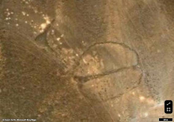 ZE imagery ZE imagery at >>26.047291, 4.691314<< ... Updated kmz file attached to OP. ... * edit: KenGrok placemarked such alignments and listed as "Burial mound w entryway (simple)" - just now I have bumped into one at >>25.900879, 4.388119<< |
|
Newbie
March 2017 - Jun 7, 2020 11:02:00 GMT
|
Post by adamnelson on Jun 1, 2020 6:15:02 GMT
This all shows us how capable we are of building things, even back in Ancient times.
|
|
Master Cartographer
April 2015 - Nov 21, 2024 8:06:11 GMT
|
Post by syzygy on Jun 19, 2020 11:05:19 GMT
Some two replies before I have posted out a new kind of structure spotted by me in Mali, now here is the first, defineately the same structure from Algeria:  No good resolution in GE at location >>22.1397137, 0.3623284<<, click on this BingMaps link instead! Updated kmz file attached to original post. (Still search purple-star placemarks for this kind of structures.) And boquet of "rondelloids" by 06.29.2021 update 85 sites (+6 suspicious structures) attached: Rondelloids - Africa.kmz (9 KB) |
|
Newbie
January 2021 - May 28, 2021 16:36:41 GMT
|
Post by daath on Jan 3, 2021 23:42:46 GMT
Hello, I am new here and would like to contribute my todays find. I am not sure if it is an ancient but definetely it is an old manmade site.
But since the upload is not working and I haven't figured out yet, who to contact for help (admins of forum or proboards?, I only share the coordinates: 27°12'20.49"N , 10°30'38.67"E & 27°12'7.14"N , 10°30'51.31"E
What do you think? 
--------------
The technical problem concerning the upload:
I get this message after trying to upload - the file has 562 KB
Is the storage of the forum content limited?
Happy new year to y'all btw !
|
|
Master Cartographer
April 2015 - Nov 21, 2024 8:06:11 GMT
|
Post by syzygy on Jan 4, 2021 9:29:34 GMT
Hi and welcome daath! Happy new year! Well, these are definetely not ancient structures. With ZoomEarth we can travel back in time to a 2011-2013 period when were already there, as all the other tracks (roads) and surface scars just like this one or look these (!) some 20 and 40 kilometers to S @ >>26.934095,10.536684<< and >>26.8479,10.470949<<. Also if you zoom out you can spot a faint grid of long, straight, parallel lines all over the wider area - example ZoomEarth linkThese all are surface scars of mining (of some kind of minerals) as: survey-grid, open-pit mines and operating (transport) routes. Next to my first example also an (abandoned) airstrip proves (one time) big-value transport of something (sure not high number of passangers)... ( : *** Despite your contribution seems to be off-topic, it is an honor you have addressed your question to me this way, also glad if I could help you! Anytime you have doubts about what you see on GE imagery, please feel free to start own forum-thread (post) for your questions. Earth Browsing sub-board I think most suitable for such open (pit) mined questions, BTW... ( : *** With your technical issues contact tek in PM (personal message)! (; --- Best and see you! G |
|
Junior Member
June 2021 - Oct 18, 2022 21:20:39 GMT
|
Post by tafrawti on Jun 16, 2021 0:16:56 GMT
|
|
Junior Member
June 2021 - Oct 18, 2022 21:20:39 GMT
|
Post by tafrawti on Jun 16, 2021 0:27:41 GMT
Some two replies before I have posted out a new kind of structure spotted by me in Mali, now here is the first, defineately the same structure from Algeria:  No good resolution in GE at location >>22.1397137, 0.3623284<<, click on this ZoomEarth link instead! Updated kmz file attached to original post. (Still search purple-star placemarks for this kind of structures.) And boquet of "rondelloids" by 09.09.2020 update 76 sites (+6 suspicious structures) attached: View AttachmentI've come across smaller versions of these when driving across various sebkha and chott (dry lake beds) and they seems to be areas of salty crust with minerals on the surface. I havent had time to check the list but drying lake beds can leave sodium deposits and lead to a crusting which can form large rings of irregular shape. Accumulations of mineral concentrate towards the outside of the areas and in some cases they get very large and take on an irregular circular shape. Not being a geologist I just assumed they were some kind of "bubble" shape of mineral deposit. I've never seen areas as large as you example in the ZE link though, plus they seem to have objects near the centre, though that could possibly just be a central pillar of mineral-bearing rock that is slowly being dissolved over the centuries by a little rainfall every few years. I think the large ones would be worth a site visit to see exactly what's going on. |
|
Junior Member
June 2021 - Oct 18, 2022 21:20:39 GMT
|
Post by tafrawti on Jun 16, 2021 0:56:45 GMT
|
|
Junior Member
June 2021 - Oct 18, 2022 21:20:39 GMT
|
Post by tafrawti on Jun 16, 2021 7:56:07 GMT
OK just had some time to browse the list of Rondelles using GE pins and clicking the ZE links.
What strikes me is that many seem to have one or more simple tumulus-like item in them, and it is NOT usually located centrally. While some are coloured white around the edges, suggesting salt-like deposits in the area, others appear to not be associated with salt-like areas. (but bear in mind that satellite imagery is usually false colour and may even be colours mapped from infra-red spectrum, especially with older images)
What intrigues me is that quite a few appear to have the edge comprised of individual small circles - from past experience this can be an indication of low vegetation where slow-growing desert plants have a thinner level of leaf or branch cover in the centre. Over many decades or centuries the plants grow outwards from a central point, with the oldest parts fo the plant becoming woody or dying out omn the centre.
I'm thinking that some of these may be enclosures for domesticated animals, since they would also need to be kept close to water if it was scarce at the time. The presence of vegetation could be explained in one of several ways, or a combination of all of the following:-
A / Thorn bush enclosures can be human-planted (not intentionally, cut thorn vegetation can be cut from it's growing position, dragged along then re-laid in an enclosure shape. Over many decades, a small but significant amount may take root like cuttings if the conditions are right. Desert plants are very tolerant of drought.
B/ Fodder fed to animals, or simply grazing in one area is digested and seeds are emitted in dung, which then established as a colony of plant species if animals are concentrated to one area by the presence of water
C/ Most plant species prefer a certain mix minerals in the soil. The link between salt-like deposits and vegetation could mean that a loose circle of vegetation develops at the edge of the salt deposit. This in turn could be exploited by pastoralist and used as an enclosure for animals or human safety, hence tumulus or bazina-like structures appear as an indirect result.
D/ An artesian well where underground water has historically seeped to the surface, providing vegetation some water. One or two of the rondelles appear to have a well at or near the centre that looks unlike the other mounds.
E/ Something else
Their very irregular shape suggests to me that these are at least partly or mainly caused by non-human activity, though the appearance of tumuli-like mounds us hard to deny from the sat photos.
The only salt deposits I have stood in are too indistinct or small to show up in current satellite imagery and had no significant vegetation growth visible around the edges that would provide cover or protection for animals or prevent them straying, though some certainly had small desert plants growing at the edge, much like a "fairy ring" of mushrooms.
|
|
Junior Member
February 2021 - Feb 5, 2021 9:41:19 GMT
|
Post by chriss on Jun 17, 2021 9:56:03 GMT
With the rondelles, I think much can be deduced from the location of the object as to whether it is ancient man-made (tombs, usually) or not. As I'm sure we have noted, tombs are very often on or near hill sides or where an escarpment meets a plane (now often dunes) and where a river may have emerged from a plateau. These rondelles seem to be in far northern Mali and just over the border in Algeria; a desolate, flat and barren region known as the Tanezrouft that is uninhabited now and probably always was, even if people may have crossed it more towards the east, or hunted there. There is no water here, no hills to make rivers or rock to collect pools - and what wells there are are bad in the long term (high chloride?). It is so flat that the first cars to cross the Sahara used this route (1920s) and the French set up water depots every 50km from Tessalit for cars and planes. So I would go with some sort of non-human salt evaporation, as suggested. Or now I think of it, salt harvesting by humans: scrapping the thin surface deposits outwards to dry in mounds along the edge? 'Petals' maybe make better wind turbulence to speed up the drying. Salt is a very important commodity from the Sahara (in the Sahel cows etc need it in the hot season), no matter how remote it is. As evidenced by the long-range salt caravans from Timbuktu to Taoudenni (Mali; rock hewn salt; 450km west of rondelles) and Agadez to Bilma (Niger; evaporation pools) which both still operate today. I think the locations are too remote and barren to be any kind of tomb. I read that Sahara tombs are no so old: some 6000 years BP when the Sahara was briefly repopulated during a less arid millennium before it returned to desert, as today. This is when most of the rock art and funerary monuments were made. I was writing about the Libyan Desert (eastern Sahara). Loads of amazing rock art there but I realised, no tombs, unlike Sahara from north Chad westward. This area has always been much more arid than the rest of the Sahara (due to Indian Ocean monsoon influence) and must have abandoned before funerary monuments became a thing. So don't waste your time searching that area ;-)  |
|
Master Cartographer
April 2015 - Nov 21, 2024 8:06:11 GMT
|
Post by syzygy on Jun 19, 2021 13:53:37 GMT
...These rondelles seem to be in far northern Mali and just over the border in Algeria; a desolate, flat and barren region known as the Tanezrouft that is uninhabited now and probably always was, even if people may have crossed it more towards the east, or hunted there. ... As evidenced by the long-range salt caravans from Timbuktu to Taoudenni (Mali; rock hewn salt; 450km west of rondelles) and Agadez to Bilma (Niger; evaporation pools) which both still operate today. I think the locations are too remote and barren to be any kind of tomb.... I was writing about the Libyan Desert (eastern Sahara). Loads of amazing rock art there but I realised, no tombs, unlike Sahara from north Chad westward. This area has always been much more arid than the rest of the Sahara (due to Indian Ocean monsoon influence) and must have abandoned before funerary monuments became a thing. So don't waste your time searching that area ;-) ... Dear chriss and tafrawti ! Well, I think this is the point where one should lean back in their chairs with pride, that top experts of our days are posting in their forum threads, but also with deep sorrow, because they have gone till the end where they only see their cherished discoveries are turning into uninteresting, worthless patterns on satellite imageries. And this also would be good this way, only if something has not been missed... I try to convince you once more and really not because of me, who hardly ever will reach further than the county borders, but I believe it would be important for you, who has the oportunity and the will to go there one day. As I have read quoted lines I thought that we are talking about different locations or you might have missed to download my main Africa kmz file, attached to original post. Yep, - if we check the ' Salt in the Sahara' kmz by our old friend, siggi and my file together we see the distance and position, but also that the area is full of the most diverse types of stone structures. 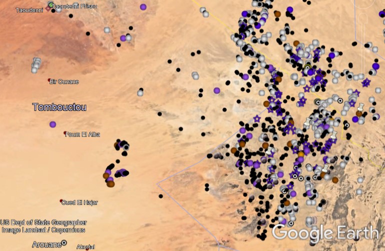 Hundreds of crescent monuments (white dots), burial mounds (black) and other types of structures all around the "rondel-zone", also KenGrok's placemarks are appearing from SE. And if we zoom in on a random site we see these are existing quite densely and next to each other:  The whole area seems to be a vast burial field with clusters of crescent monuments and burial mounds:  And these huge structures, that can only be find around here and that no way I can see natural patterns...:  Sorry for my brief reaction, but even it was exhausting without the mouse and keyboard. I admit in many cases these are irregular and aligned to nature, but I am sure also man made structures, built up of cca. 20 meters diameter arcs of stones and are acompanied with tumuli (burial or other purpose). A less buried double structure as a last example:  Please check main kmz file before you drop these structures for ever! *** Many thanks for all the most useful and honourable comments of yours! With best regards, G |
|
Junior Member
February 2021 - Feb 5, 2021 9:41:19 GMT
|
Post by chriss on Jun 19, 2021 15:54:08 GMT
The salt harvesting idea was just something that occurred to me, but they do have a man-made look about them. Yes, I see now the rondels are in a very dense area in or near the Adrar des Ifoghas highlands. All I am saying is they look a bit sloppy compared to typical, finely built tombs. Maybe 'multiple crescents'? Seems unlikely. Unfortunately there is more chance to visit Mars than visit this area right now. The full kmz file is impressive, even if I cannot se clearly with Google. Am I right in saying I cannot import kmz into Bing to view more clearly than Google murk? I get a feeling there is a lot more to find in Western Sahara where, as tafrawti mentioned, Nick Brooks and his colleagues have been active for many years. His galleries here: www.flickr.com/photos/western_sahara_project/albums |
|
Master Cartographer
April 2015 - Nov 21, 2024 8:06:11 GMT
|
Post by syzygy on Jun 19, 2021 22:04:47 GMT
... Unfortunately there is more chance to visit Mars than visit this area right now. ... Am I right in saying I cannot import kmz into Bing to view more clearly than Google murk? ... I do not know about such kmz imports to Bing, but every placemark in my kmz contains a link in description to other map engines where resolution is low on GE. (click/tap on placemark to view descriptions) Many thanks for the great photo database! Is there any map-key for the image codes on Flickr? I have got to know not long ago about these Moroccan "small brothers". Obvious similarities on a much smaller scale and to make the story a bit more interesting I have started to set up theories about (cultural/architectural?) connections with these calcolithic sinuous enclosures from Portugal. You're the 2nd Africa explorer who told me that recently it is impossible to access that region. Shame, I know less about the general situation in my neighboring continent, but really nothing comes from the "tubes"... What does 'recently' means and why 'that' exact region? (barren enough for kidnappers to hide?)* *edit: Meanwhile I have read some relevant on SaharaOverland, so sad reality is much more clear for me now. Sorry if my previous reply seemed to be somewhat desperate, but since I have spotted the first one I am getting the more excited by each new find or as a faint clue comes up about these strange structures. (since you have joined and revived this thread I spotted 4 more on ZoomEarth imagery - kmz attachments updated) Something like '32' for tafrawti ... ( : The 'mini-crescents' concept has also been put aside by me, however aerodynamic characteristics of the shape still don't let me... arcs, crescent monuments... the shape of Barkhan dunes... |
|
Junior Member
June 2021 - Oct 18, 2022 21:20:39 GMT
|
Post by tafrawti on Jul 14, 2021 1:12:50 GMT
I have been wondering if these larger rondelles are actually very large ancient boma, thorn-brush enclosures for people and livestock (similar to a kraal in southern Africa) Vegetation would have been more prevalent around 5000 to 8000 years before present. The original cut thorn brush would probably have decayed after several centuries but terrain marks would have been left by accumulations of find wind-blown sand.
The looped/frilled edge to them suggests a defensive use to me, possibly being used as overnight laying-up areas for trade caravans in centuries or even millenia gone by. The history certainly has a long history of banditry.
edit: or possibly protection from wild animals, (such as large dangerous felines, known to exist across much of the Sahara in antiquity)
|
|
Full Member
November 2020 - Sept 25, 2024 11:02:30 GMT
|
Post by bemerkenswelt on Mar 25, 2022 14:35:29 GMT
I have some more of this so called "Compass tombs" See attached KMZ After "crescents", "needles", "causeways" and "antennae" here you are another kind of stone alignments around burial mounds, I have dubbed "drops" as these are look as giant, elongated water-drops. (The abbreviation I use "dst" is for "drop shaped /geoglyph/ tumuli.) I have mapped 7 of this kind so far and these are seem to be concentrated around one, special burial hill around >>22.521682, 16.567928<< in Chad, where I have spotted them: *** Attachments:Kompassgrab.kmz (27.72 KB)
|
|
Master Cartographer
April 2015 - Nov 21, 2024 8:06:11 GMT
|
Post by syzygy on Mar 28, 2022 6:44:55 GMT
Hi and welcome back bemerkenswelt! Some of your marks (only a few) seem to be natural formations but most of them are excellent contributions to these collections! Thanks you so much for sharing! - After some selection and processing I may insert some parts with credit given of course. -- Take my congrats on your cool webpage! ( ; See you! G |
|
Full Member
November 2020 - Sept 25, 2024 11:02:30 GMT
|
Post by bemerkenswelt on Mar 28, 2022 11:06:02 GMT
Thank you for the welcome. Because it has been a long time I wasn't here, I'll attach some of my placemarks, found in the meantime.
Maybe it's useful for somebody.
bye
ATTENTION:
The attached files contain my work from the past 10 years.
So they are very large and can cause weaker systems to hang.
Even in stronger systems it can take a long time for GE to open
or even to show the placemarks when checked (up to 10 minutes or more).
So be very patient!
My recommendations:
• Start with the smalest KMZ-file, which is "Levant".
• Do not check all the placemarks in one, but folder by folder.
• If you know your system is not very strong, please skip "Sahara".
• Do not close the GE program without having uncheckt all the placemarks.
Otherwise next time your GE could need at least half an hour to open.
|
|
Junior Member
September 2021 - Sept 23, 2024 14:04:01 GMT
|
Post by buildsancient on Mar 29, 2022 15:54:19 GMT
That's INCREDIBLE work. Wünderbar!
|
|
Full Member
November 2020 - Sept 25, 2024 11:02:30 GMT
|
Post by bemerkenswelt on Mar 31, 2022 9:30:44 GMT
The finds in Ethiopia and Djibouti are also extremely interesting.
I am particularly fascinated by these strange sticks. But until now, nobody could tell me what this is.
Very mysterious.
|
|
Full Member
November 2020 - Sept 25, 2024 11:02:30 GMT
|
Post by bemerkenswelt on Mar 31, 2022 20:45:49 GMT
What is this? A rondelloid in Libya, about 1,500 km away from the others, syzygy found before?
Attachments:Rondelloid-Libya.kmz (675 B)
|
|
Master Cartographer
April 2015 - Nov 21, 2024 8:06:11 GMT
|
Post by syzygy on Apr 11, 2022 12:06:37 GMT
What is this? A rondelloid in Libya, about 1,500 km away from the others, syzygy found before? ... I have known about these also I heard about existence of similar "small-arc" stone arrangements in Morocco, but these have nothing to do with those Malian-Algerian complex structures that I call "rondelloids" Taking your example, diameter of the arcs is only about 2,5 meters, while an average 20 meters diameter can be measured for the arcs of "my" rondelloids. If we consider (only arc) dimensions, still closest relatives can be those calcolithic-age "sinuous enclosures" from Portugal. ( Link to post in this thread.) Too some 1500 km away, only to another direction... ( : --- Thanks for valuable link and placemark anyways! Both are great contributions to this thread! |
|
Master Cartographer
April 2015 - Nov 21, 2024 8:06:11 GMT
|
Post by syzygy on Apr 11, 2022 12:49:23 GMT
And to add more to comparative archaeology in this thread, here is another strange similary, I just have noticed. Do not you think these 3000 year old Nuragic structures ( sacred wells) from Sardenga are way too similar in shape and structure to the "Keyhole monuments" of the Sahara?   As if were not only coincidence... what do you think? Pacemarks for the example sites above: Nuragic structures - Sardenga.kmz (919 B) |
|
Full Member
November 2020 - Sept 25, 2024 11:02:30 GMT
|
Post by bemerkenswelt on Apr 11, 2022 18:01:22 GMT
As if were not only coincidence... what do you think? I know those Nuragic wells and thought also a moment about this, when I saw them first time.
They look amazingly similar, but I think that's pure coincidence.
People use the same basic shapes everywhere. Circles, ovals, rectangles and corridors.
|
|


 #
# #
# #
#


