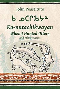
When I Hunted Otters and other stories (Ka-nutachikwayan)
May 22, 2021 19:59:13 GMT
frankmcvey (Angel) and syzygy like this
Post by Bill Jancewicz on May 22, 2021 19:59:13 GMT
Ka-nutachikwayan: When I Hunted Otters and other stories
This set of placemarks (in the .kmz file attached) are all referenced in the collection of Naskapi stories and legends entitled “Ka-nutachikwayan: When I Hunted Otters and other stories”. These are locations in Naskapi traditional territory in Northern Quebec that have been documented by the Naskapi Development Corporation's Translation and Linguistics Services Department, which is engaged in developing quality Naskapi language materials for the use and benefit of the Naskapi community.
The placemarks in this posting use the traditional names of the places in the Naskapi language, and most are also transcribed in Canadian syllabics, which is the writing system used by the Naskapi people.

The Naskapi book “Ka-nutachikwayan: When I Hunted Otters and other stories” tell oral accounts passed down for generations of Naskapi people about their lives on the land. The stories selected for this book are tipâchimûna, a story type which refers to reported accounts that the storyteller heard and re-tells for his audience: "Kinuwapinuw" (Story 31), "Kapisaukin" (Story 33), "When I Hunted Otters" (Story 34), "A Journey East" (Story 35), and "Miskahtuyapaw" (Story 36), are these types of retellings. Indeed, the stories "When I Hunted Otters" (Story 34), and "A Journey East" (Story 35) are first-hand eyewitness accounts by the storyteller himself.
An important feature of John Peastitute’s rendition of the tipâchimûna in this book is his systematic and accurate inclusion of Naskapi place names that refer to actual geographic features that provide a physical setting for the events in the stories. The Naskapi Toponymy Project provided the data and locations for the maps that were especially drawn for this edition, in the book on pages 24-25 (maps in Naskapi) and 64-65 (maps in English).
What follows is an excerpt from the English translation of the story, “A Journey East” (Story 35), in which the storyteller recounts a cross-country trip by canoe (beginning in summer) which turns to tragedy in a sudden early-winter blizzard, and then becomes a long winter journey by snowshoe out to the Labrador coast and back to Fort Chimo on Ungava bay. Throughout the account, the storyteller mentions the Naskapi toponymns (place names) by which interested readers can follow their progress across the subarctic tundra and taiga regions of traditional Naskapi territory which is now Northern Quebec and Labrador.
"1 Now I’m going to tell the anthropologist a story about the time I saw Nânuwâw. 2 We set off in our canoes from here [gesture], from here at Fort McKenzie. 3 That’s where we embarked from, and from here [gesture] we paddled to Nâchikupâw and Musâwâkuskin , to the place known as Kâukwâskwâsuw , and to Kâipîhkupâw , Kischitikâhikin and Wâsâupistâwâkin . 4 Nânuwâw , Kâpisischâyâw , and Kâtuwâkitutinâw , 5 these are the last big lakes along the way. Kâtuwâkitutin is close to where Musuwâw sîpuw flows. 6 Having been inland, we reached the shore on Musuwâw sîpuw . It was still summer. On Musuwâw sîpuw was where we were.
7 When the snow began, when there was snow, we took off across the river, across Musuwâw sîpuw. That’s where we left from. ..."
The various place names in this story are footnoted in the book as follows:
Audio versions of the stories can be found here:
yourlisten.com/NDevCorp
Posts related to this thread: googleearthcommunity.proboards.com/thread/6410/whale-hunt-stories-wapimakuch-nuchahakinuch
...and here: googleearthcommunity.proboards.com/thread/922/naskapi-achan-stories
This set of placemarks (in the .kmz file attached) are all referenced in the collection of Naskapi stories and legends entitled “Ka-nutachikwayan: When I Hunted Otters and other stories”. These are locations in Naskapi traditional territory in Northern Quebec that have been documented by the Naskapi Development Corporation's Translation and Linguistics Services Department, which is engaged in developing quality Naskapi language materials for the use and benefit of the Naskapi community.
The placemarks in this posting use the traditional names of the places in the Naskapi language, and most are also transcribed in Canadian syllabics, which is the writing system used by the Naskapi people.
The book, “Ka-nutachikwayan: When I Hunted Otters and other stories” features Naskapi stories written in the Naskapi language as told by the late Naskapi elder John Peastitute. It also contains an English literary translation, analysis, background and other linguistic and cultural details about the Naskapi people.

Peastitute, John. 2021. “Ka-nutachikwayan: When I Hunted Otters and other stories” Kawawachikamach, Quebec. Naskapi Development Corporation.
The Naskapi book “Ka-nutachikwayan: When I Hunted Otters and other stories” tell oral accounts passed down for generations of Naskapi people about their lives on the land. The stories selected for this book are tipâchimûna, a story type which refers to reported accounts that the storyteller heard and re-tells for his audience: "Kinuwapinuw" (Story 31), "Kapisaukin" (Story 33), "When I Hunted Otters" (Story 34), "A Journey East" (Story 35), and "Miskahtuyapaw" (Story 36), are these types of retellings. Indeed, the stories "When I Hunted Otters" (Story 34), and "A Journey East" (Story 35) are first-hand eyewitness accounts by the storyteller himself.
An important feature of John Peastitute’s rendition of the tipâchimûna in this book is his systematic and accurate inclusion of Naskapi place names that refer to actual geographic features that provide a physical setting for the events in the stories. The Naskapi Toponymy Project provided the data and locations for the maps that were especially drawn for this edition, in the book on pages 24-25 (maps in Naskapi) and 64-65 (maps in English).
What follows is an excerpt from the English translation of the story, “A Journey East” (Story 35), in which the storyteller recounts a cross-country trip by canoe (beginning in summer) which turns to tragedy in a sudden early-winter blizzard, and then becomes a long winter journey by snowshoe out to the Labrador coast and back to Fort Chimo on Ungava bay. Throughout the account, the storyteller mentions the Naskapi toponymns (place names) by which interested readers can follow their progress across the subarctic tundra and taiga regions of traditional Naskapi territory which is now Northern Quebec and Labrador.
"1 Now I’m going to tell the anthropologist a story about the time I saw Nânuwâw. 2 We set off in our canoes from here [gesture], from here at Fort McKenzie. 3 That’s where we embarked from, and from here [gesture] we paddled to Nâchikupâw and Musâwâkuskin , to the place known as Kâukwâskwâsuw , and to Kâipîhkupâw , Kischitikâhikin and Wâsâupistâwâkin . 4 Nânuwâw , Kâpisischâyâw , and Kâtuwâkitutinâw , 5 these are the last big lakes along the way. Kâtuwâkitutin is close to where Musuwâw sîpuw flows. 6 Having been inland, we reached the shore on Musuwâw sîpuw . It was still summer. On Musuwâw sîpuw was where we were.
7 When the snow began, when there was snow, we took off across the river, across Musuwâw sîpuw. That’s where we left from. ..."
The various place names in this story are footnoted in the book as follows:
- The storyteller sets the scene by referring to Fort McKenzie as ‘here’, being the starting point for the journey in this story. Often, the Hudson’s Bay posts Fort Chimo and Fort McKenzie are referred to as Wâskâhîkin, literally ‘house’; in general this word was used for Fort Chimo. Wâskâhîkinis, literally ‘small house’ was often used to refer to Fort McKenzie, which is a smaller outpost. But in this case, the storyteller says Mâkinisî ‘McKenzie’, removing any doubt. (56° 49′ 48.00″ N / 68° 57′ 3.60″ W) See maps on pages 64 and 65.
Nâchikupâw ‘standing together lake’ (Lac Nachicapau, elevation 173m, 56° 39′ 41.26″ N / 68° 11′ 3.52″ W).
Musâwâkuskân nipîy ‘open water fishing lake’ (elevation 251m, 56° 44′ 16.46″ N / 67° 40′ 14.25″ W).
Kâukwâskwâsuw nipîy ‘birch tree lake’ (Lac Horseshoe, elevation 259m, 56° 40′ 19.85″ N / 67° 37′ 1.09″ W).
Kâipîhkupâw nipîy ‘willow lake’ (Lac Wheeler, elevation 271m, 56° 36′ 40.75″ N / 67° 24′ 41.22″ W).
Kischitikâhikin nipîy ‘steep rock lake’ (Lac Katakatawasitich, elevation 304m, 56° 34′ 51.85″ N / 67° 14′ 36.25″ W).
Wâsâupistâwâkin nipîy ‘net-fishing-bay lake’ (Lac Jeannin, elevation 343m, 56° 29′ 51.68″ N / 66° 24′ 2.63″ W).
Nânuwâw nipîy ‘curved? lake’ (Lac Ninawawe, elevation 317m, 56° 35′ 24.04″ N / 66° 12′ 10.73″ W).
Kâpisischâyâw nipîy ‘lake in a gorge that gets narrower’ (Lac Uzureau, elevation 261m, 56° 49′ 25.61″ N / 66° 18′ 30.64″ W).
Kâtuwâkitutinâw nipîy ‘lake near a mountain with barren top and trees on the slopes’ (elevation 384m, 56° 55′ 50.40″ N / 65° 22′ 49.28″ W).
Musuwâw sîpuw ‘barren-ground river’ (George River; at this point on the river the elevation is 251m, at 56° 56′ 50.09″ N / 65° 9′ 42.23″ W).
Audio versions of the stories can be found here:
yourlisten.com/NDevCorp
Posts related to this thread: googleearthcommunity.proboards.com/thread/6410/whale-hunt-stories-wapimakuch-nuchahakinuch
...and here: googleearthcommunity.proboards.com/thread/922/naskapi-achan-stories
Feel free to contact me if you have any questions or suggestions to improve this thread.
Bill Jancewicz


