Master Cartographer
April 2015 - Nov 21, 2024 8:06:11 GMT
|
Post by syzygy on Dec 10, 2019 13:56:09 GMT
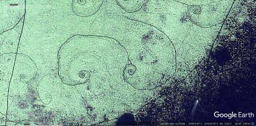
...and one another "mistery" from Africa, now from DRC: I have found location on the Net, on the blog page - Man-made Lakes Of Africa - authored by blogger Zero Control. They say these are some man-made patterns. Parts of some kind of "water-management" process, which eventually leads to bigger water surfaces.  for an unknown reason, I am sceptic... as if I have already heard about them somewhere before in oGEC times... that is why I have shared here as a question addressed to all experts of GEC: - whadda spiral hell do you think is that all over the place, where that light coloured vegetation covers the water? three sites I have placemarked. - the second one in attached kmz folder signs a site, where nothing happened, except that spiral pattern has changed from 2009 to 2012. also by the third marker, this change can be observed. (check GE historical imagery by these). swamp spirals - DRC.kmz (1.23 KB) has anyone around heard about these before? - any explanation? - any ideas? Thanks! g |
|
Master Gamer
April 2018 - Nov 20, 2024 20:32:38 GMT
|
Post by willi1 on Dec 10, 2019 17:02:22 GMT
The question is man made or of natural origin.
In the first case, I do not see the right sense.
In the second case, I guess: water vortexes, which arrange floating plants to patterns in shallow water.
|
|
Master Cartographer
April 2015 - Nov 21, 2024 8:06:11 GMT
|
Post by syzygy on Dec 10, 2019 21:45:25 GMT
no way these are about turbulent flow! far too custom size and regular alignment (by the screenshot example) with rather big dimensions (approx. average largest diameter of 190 meters). I think these are man made - probably a fishing practice (?) speedboat entering the straight corridor at bottom-right of screenshot makes me imagine at least, these spirals were slit into vegetation by boats...  still I'm just groping in the dark however... |
|
Full Member
January 2020 - Jan 5, 2024 10:40:59 GMT
|
Post by leong on Jan 16, 2020 7:25:44 GMT
These are on a very flat areas. The berm being only 20cm or so high, well its only going to catch 10cm of water... but given the gentle slope, it catches a lot of water.
Do you miss the rains down the africa ? well the idea was to the rain does not go missing... to ensure more water soaks into the ground than without the berms
|
|
Master Cartographer
April 2015 - Nov 21, 2024 8:06:11 GMT
|
Post by syzygy on Jan 17, 2020 12:11:08 GMT
water-traps? - whoa, something that could make sense! - thanks leong! how do you know? - have you any source for this? - I mean, it seems you are quite sure... |
|


