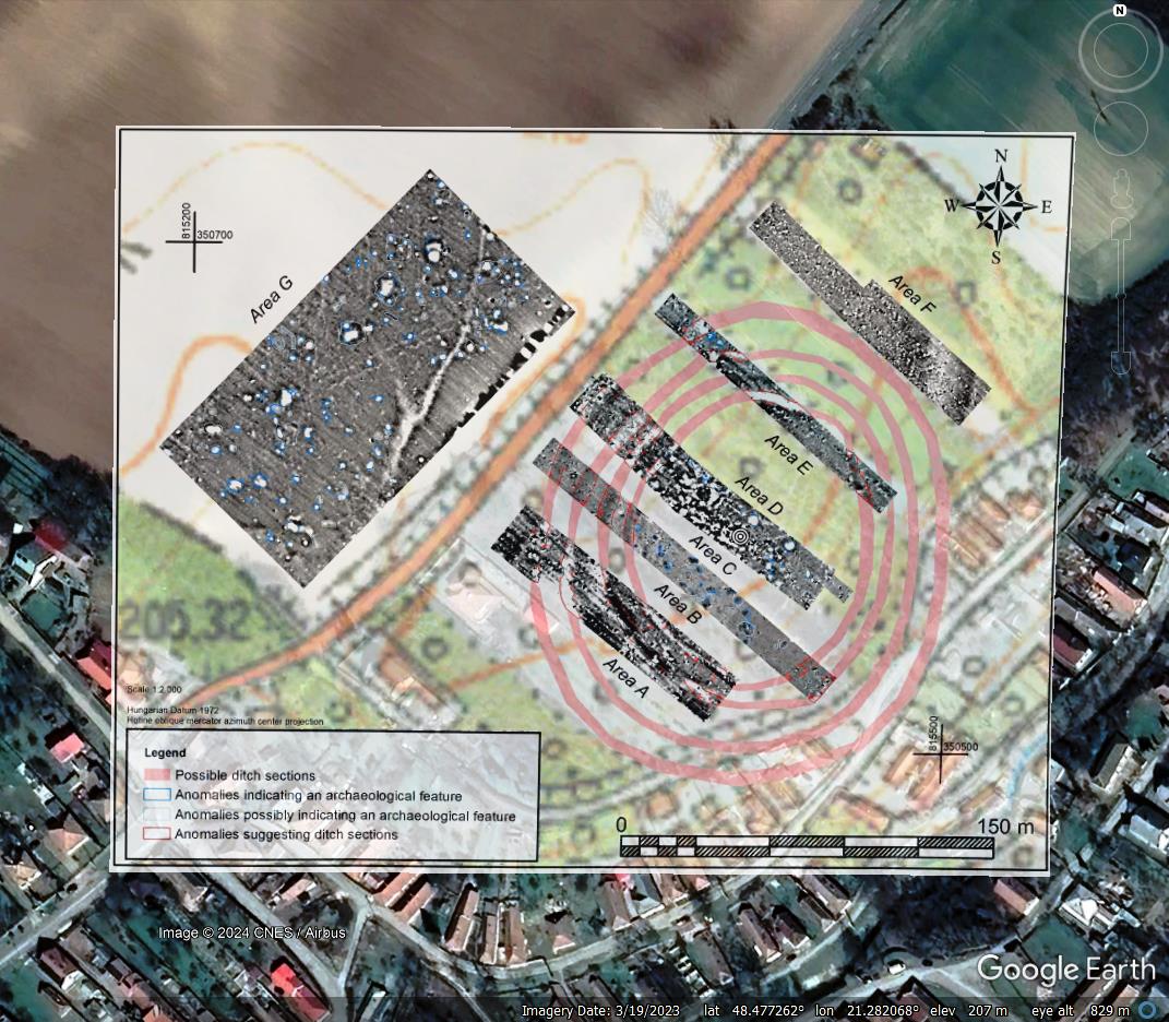
Post by syzygy on Mar 22, 2018 14:28:07 GMT
Hi All!
I have deleted all individual posts of mine about these kind of archaeological sites as decided to put together all and make it a collection.
Below I quote the deleted posts' text bodies, those were to introduce the 6 sites, I have previously made kmz content for.
All the forthcoming updates will produce a reply post by me and an updated kmz file attched to this Original Posting.
By the start also need to be mentioned another thread of mine with quite a similar title: Prehistoric circular enclosures where I try to locate sites with primary cultic/astrometrical- and not settlement functions as it stands by these.
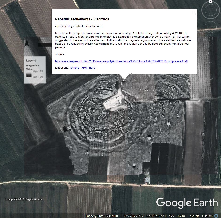
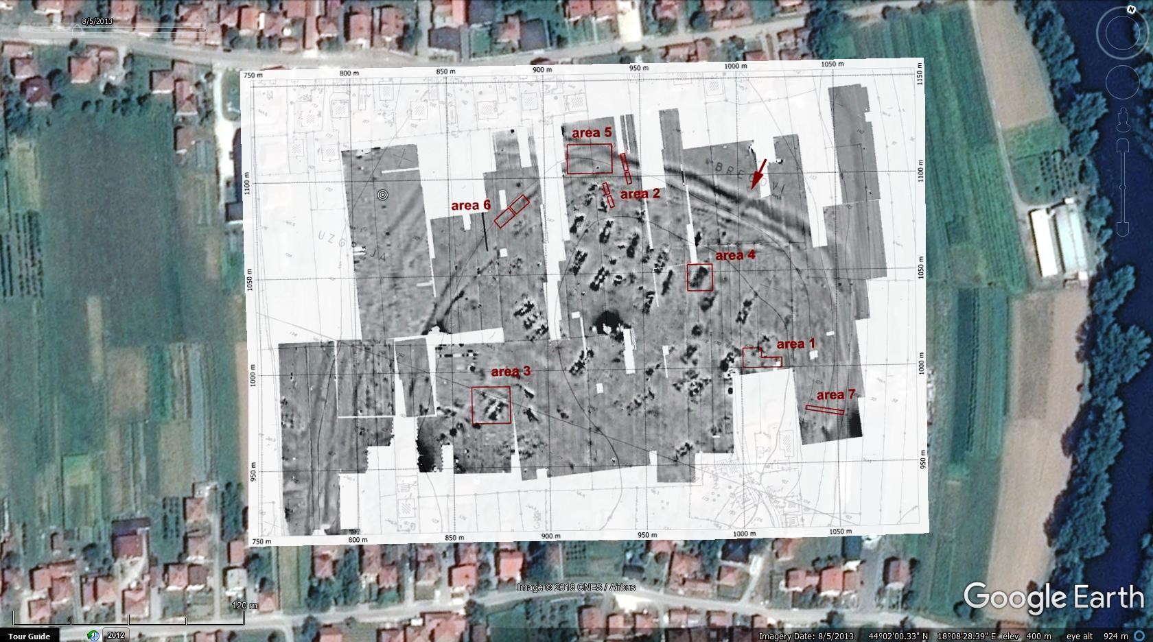
So the 6 neolithic settlements of this first update:
***
Prehistoric Enclosured Settlements.kmz (17.82 KB)
By last update placemarks for 27 sites (overlays for 16) from 12 countries in attached kmz folder. - All the outlines and overlays OFF as default.
Related from board:
Prehistoric circular enclosures
Ancient Saudi Stone Structures
My archaeology collection
Mounds of (the) Earth
all archaeo threads by archaeo,
Related from oGEC:
Placemark-thousands of The Megalithic Portal guide to 25000+ ancient sites worldwide by Andy Megalithic,
Neolithic sites in Arabia and East Africa by KenGrok
Neolithic Monuments of the Sahara by KenGrok
Historical Atlas of Eurasia by RWFG
Art of the steppe nomads by Villaman
The frozen tombs of the Altai by Belizarius
North American Archaeology 2013 by deansnow
I have deleted all individual posts of mine about these kind of archaeological sites as decided to put together all and make it a collection.
Below I quote the deleted posts' text bodies, those were to introduce the 6 sites, I have previously made kmz content for.
All the forthcoming updates will produce a reply post by me and an updated kmz file attched to this Original Posting.
By the start also need to be mentioned another thread of mine with quite a similar title: Prehistoric circular enclosures where I try to locate sites with primary cultic/astrometrical- and not settlement functions as it stands by these.
So the 6 neolithic settlements of this first update:
Neolithic site - Kurt Orman, Bulgaria

enclosure ditches clearly visible by proper imagery dates
***
source: academia.edu

enclosure ditches clearly visible by proper imagery dates
***
source: academia.edu
Neolithic site - Altheim, Germany
THE LATE NEOLITHIC EARTHWORKS AT ALTHEIM (GERMANY)
by Thomas Saile
"In 2012, fieldwork recommenced at the Altheim earthwork, discovered more than a century ago. The investigation in its immediate environs revealed a second ditched enclosure from the Altheim period, south-east of the previously known structure. The two enclosures are spatially related to one another. It was found that several decimetres of soil have been eroded during the last hundred years in the area of the north earthwork; the very substance of both monuments is acutely threatened.
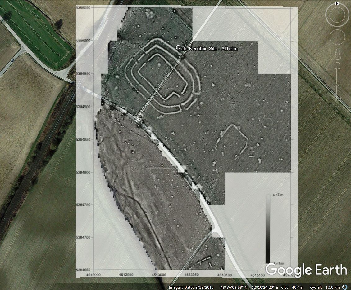
The first radiocarbon datings, carried out on samples of domestic animal bone, allow both enclosures to be dated to the 37th / 36th century BC and suggest a temporal sequence of the ditches. Certain earlier observations, namely the high proportion of arrowheads among the flaked stone tools and the very low proportion of bones from wild animal bones, were confirmed by the new excavation. The southwest-northeast orientation of the structures’ long axes permits an archaeoastronomical interpretation: knowledge obtained from the observation of natural phenomena was transferred to architecture. The new investigation sheds further doubt on the interpretation of the enclosures as fortifications. ..."
source:
uf.uni-erlangen.de / PDF
***
(only a short section of the enclosure and just slightly is visible as cropmark on set to date imagery. - check overlay in proper subfolder)
THE LATE NEOLITHIC EARTHWORKS AT ALTHEIM (GERMANY)
by Thomas Saile
"In 2012, fieldwork recommenced at the Altheim earthwork, discovered more than a century ago. The investigation in its immediate environs revealed a second ditched enclosure from the Altheim period, south-east of the previously known structure. The two enclosures are spatially related to one another. It was found that several decimetres of soil have been eroded during the last hundred years in the area of the north earthwork; the very substance of both monuments is acutely threatened.

The first radiocarbon datings, carried out on samples of domestic animal bone, allow both enclosures to be dated to the 37th / 36th century BC and suggest a temporal sequence of the ditches. Certain earlier observations, namely the high proportion of arrowheads among the flaked stone tools and the very low proportion of bones from wild animal bones, were confirmed by the new excavation. The southwest-northeast orientation of the structures’ long axes permits an archaeoastronomical interpretation: knowledge obtained from the observation of natural phenomena was transferred to architecture. The new investigation sheds further doubt on the interpretation of the enclosures as fortifications. ..."
source:
uf.uni-erlangen.de / PDF
***
(only a short section of the enclosure and just slightly is visible as cropmark on set to date imagery. - check overlay in proper subfolder)
Neolithic site - Viitivka, Ukraine
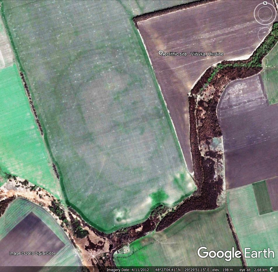
"... the Viitivka site (Trypillia CI; Bershad district) is a large (about 50 ha) settlement, planned by two ovals. In the northeastern part of the settlement two radial house rows and some spots between them can be traced. The central eastern part of the settlement with radial streets was measured by geomagnetic survey (about 10 ha). The geomagnetic plan confirmed the planning of the settlement. Several typical anomalies like buildings, pits and possible kilns were detected. The most interesting find in the central eastern plaza is a complex of three „megastructures” (the largest has an area about 700 m2), accompanied by large lateral pits and two polygonal objects which are difficult to interpret. ..."
source: uf.uni-erlangen.de/(PDF)
on GE imagery cropmark of the double ditched enclosure easily can be spotted:
***
"... the Viitivka site (Trypillia CI; Bershad district) is a large (about 50 ha) settlement, planned by two ovals. In the northeastern part of the settlement two radial house rows and some spots between them can be traced. The central eastern part of the settlement with radial streets was measured by geomagnetic survey (about 10 ha). The geomagnetic plan confirmed the planning of the settlement. Several typical anomalies like buildings, pits and possible kilns were detected. The most interesting find in the central eastern plaza is a complex of three „megastructures” (the largest has an area about 700 m2), accompanied by large lateral pits and two polygonal objects which are difficult to interpret. ..."
source: uf.uni-erlangen.de/(PDF)
on GE imagery cropmark of the double ditched enclosure easily can be spotted:

***
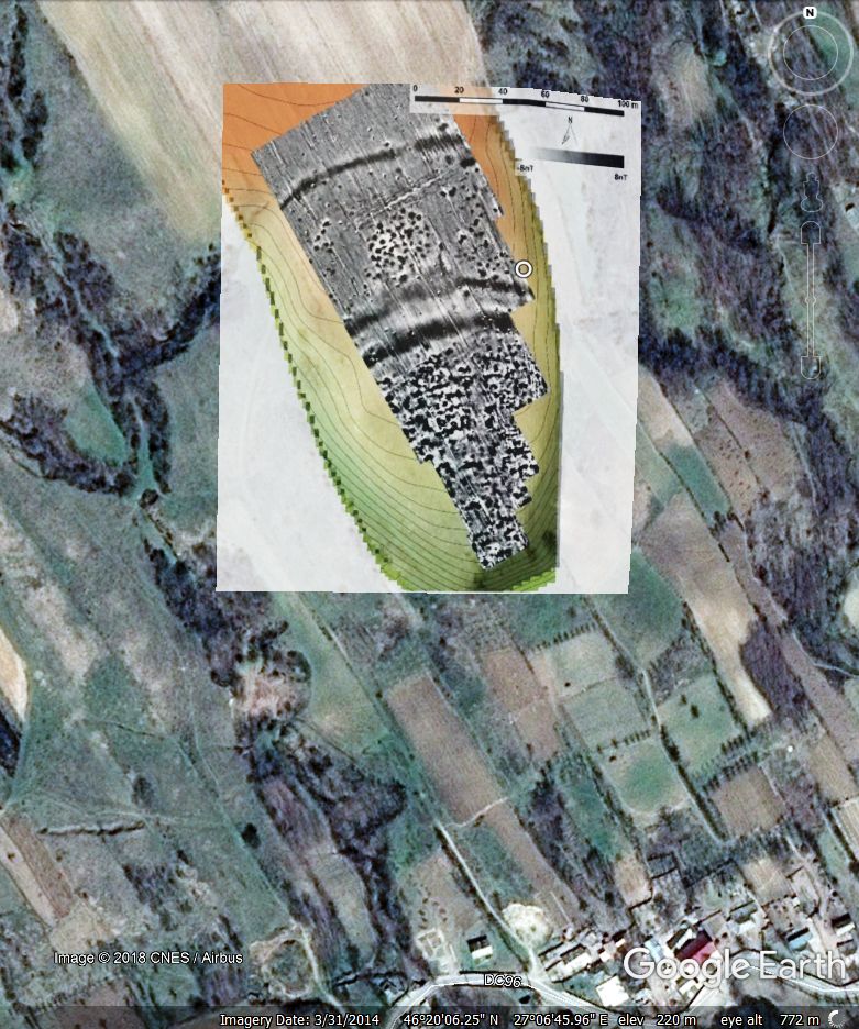
Neolithic site - Scanteia, Romania
"Scânteia (National Archaeological Record of Romania – Code 98925.01) dated mainly to Cucuteni–A3 phase is one of the most intensively surveyed Cucuteni sites in Romania. ... Nevertheless the typical features of Cucuteni sites, burned houses and ditches, appear clearly. The results reveal a settlement, whose spatial organization, unless also situated on a promontory, is not so clearly predicted by the terrain as known from most of the other surveyed sites.
...
At least three ditches can be seen in the magnetogram. The outer one, encircling nearly the complete perimeter of settlement shows a width of 5–8 m and encloses an area of 6 ha. In the west and south this ditch is paralleled by an inner one with a width of 3–5 m approximately 4 ha. In the south of the settlement, another ditch with comparable size is running parallel to the double ditch system. Measurements at comparable sites in Transylvania have shown that this is only the minimum of enclosing elements, as additional palisades with more shallow and narrow foundations can hide between the bigger structures, invisible for the gradiometery. ... "

source: arheo.ro (PDF)
***
(cropmark of the structure is slightly visible by proper imagery date - check for overlay)
"Scânteia (National Archaeological Record of Romania – Code 98925.01) dated mainly to Cucuteni–A3 phase is one of the most intensively surveyed Cucuteni sites in Romania. ... Nevertheless the typical features of Cucuteni sites, burned houses and ditches, appear clearly. The results reveal a settlement, whose spatial organization, unless also situated on a promontory, is not so clearly predicted by the terrain as known from most of the other surveyed sites.
...
At least three ditches can be seen in the magnetogram. The outer one, encircling nearly the complete perimeter of settlement shows a width of 5–8 m and encloses an area of 6 ha. In the west and south this ditch is paralleled by an inner one with a width of 3–5 m approximately 4 ha. In the south of the settlement, another ditch with comparable size is running parallel to the double ditch system. Measurements at comparable sites in Transylvania have shown that this is only the minimum of enclosing elements, as additional palisades with more shallow and narrow foundations can hide between the bigger structures, invisible for the gradiometery. ... "

source: arheo.ro (PDF)
***
(cropmark of the structure is slightly visible by proper imagery date - check for overlay)
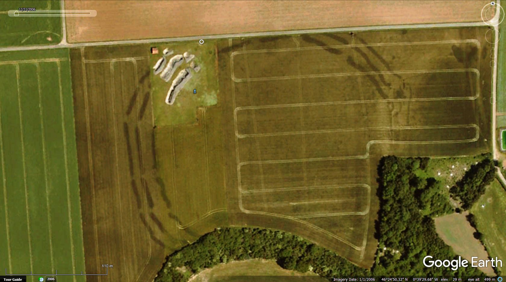
Neolithic site - Bellevue, France
Another unmarked neolithic site from another abstract of a magnetic survey in western France. On set imagery date (by overlay off), cropmark detail is visible.

source: researchgate.net
Another unmarked neolithic site from another abstract of a magnetic survey in western France. On set imagery date (by overlay off), cropmark detail is visible.

source: researchgate.net
Neolithic site - Le Pontet, France
Another magnetic survey I have found and extracted overlay from as usual, besides, by set imagery date, cropmark of the feature is also clearly visible.
source
Another magnetic survey I have found and extracted overlay from as usual, besides, by set imagery date, cropmark of the feature is also clearly visible.
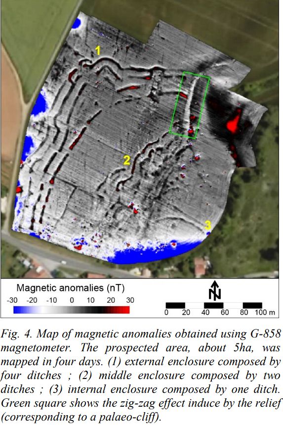
...The Neolithic site of Le Pontet at Saint-Nazaire-surCharente (Charente-Maritime, France) is located near the estuary of the River Charente and close to the city of Rochefort. ... It was identified by aerial photographs showing the presence of four subparallel and discontinuous ditches. Their morphology and material found on the surface indicate that they correspond to the late Neolithic period. The site is established on limestone cliff bordering a small valley leading to River Charente. A multidisciplinary study is being conducted in this wetland so as to establish the palaeo-environmental context associated to the Holocene Neolithic settlement.
...
The Neolithic site has a great enclosure of four discontinuous and subparallel ditches, then a second one enclosure inside and finally a third one enclosure composed by a unique ditch. This survey allows to detect many more specific anomalies of various sizes.
...
-----------------------------------------------------------------------------------------------------------------------------------------------------
Guillaume Bruniaux, François Lévêque, Vivien Mathé, Adrien Camus, Carole Romey, et al.. High spatial
resolution magnetic survey on the Neolithic site of Le Pontet (Charente-Maritime, France): presentation
of the method and associated processing. 1st International Conference on Metrology for Archaeology
(MetroArcheo), Oct 2015, Benevento, Italy. Proceedings of the 1st International Conference on
Metrology for Archaeology, 1, pp.550-555, 2015, <http://193.206.108.81/metroarcheo2016/2015/>.
<hal-01520765>
...
The Neolithic site has a great enclosure of four discontinuous and subparallel ditches, then a second one enclosure inside and finally a third one enclosure composed by a unique ditch. This survey allows to detect many more specific anomalies of various sizes.
...

-----------------------------------------------------------------------------------------------------------------------------------------------------
Guillaume Bruniaux, François Lévêque, Vivien Mathé, Adrien Camus, Carole Romey, et al.. High spatial
resolution magnetic survey on the Neolithic site of Le Pontet (Charente-Maritime, France): presentation
of the method and associated processing. 1st International Conference on Metrology for Archaeology
(MetroArcheo), Oct 2015, Benevento, Italy. Proceedings of the 1st International Conference on
Metrology for Archaeology, 1, pp.550-555, 2015, <http://193.206.108.81/metroarcheo2016/2015/>.
<hal-01520765>
***
Prehistoric Enclosured Settlements.kmz (17.82 KB)
By last update placemarks for 27 sites (overlays for 16) from 12 countries in attached kmz folder. - All the outlines and overlays OFF as default.
Attached kmz file only available here on the every-time "Live" GE Community Forums, which is now self-sponsored. If You make good use of this dataset, please donate our community! Thank You! |
Related from board:
Prehistoric circular enclosures
Ancient Saudi Stone Structures
My archaeology collection
Mounds of (the) Earth
all archaeo threads by archaeo,
Related from oGEC:
Placemark-thousands of The Megalithic Portal guide to 25000+ ancient sites worldwide by Andy Megalithic,
Neolithic sites in Arabia and East Africa by KenGrok
Neolithic Monuments of the Sahara by KenGrok
Historical Atlas of Eurasia by RWFG
Art of the steppe nomads by Villaman
The frozen tombs of the Altai by Belizarius
North American Archaeology 2013 by deansnow



 _
_


