Master Cartographer
April 2015 - Dec 4, 2024 20:55:47 GMT
|
Post by syzygy on Jan 18, 2024 10:32:05 GMT
For planes from Poland to the North Pole 50.247036° 19.417234°
Wow, just next to the JPII sign... Thanks for the great addition willi1 ! Updated kmz file attached to OP! |
|
Master Gamer
April 2018 - Dec 4, 2024 20:57:55 GMT
|
Post by willi1 on Feb 5, 2024 21:16:14 GMT
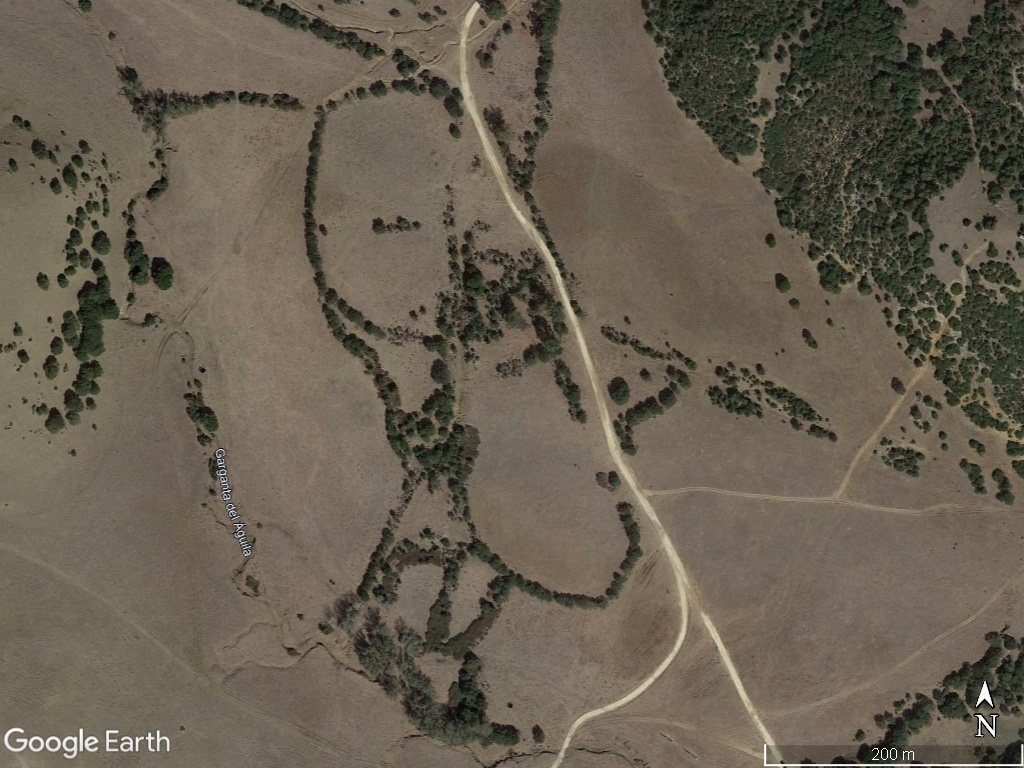
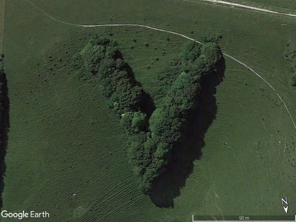
Moai Tree 36.211445° -5.848964°
|
|
Master Cartographer
April 2015 - Dec 4, 2024 20:55:47 GMT
|
Post by syzygy on Feb 6, 2024 10:11:47 GMT
Nice catch! As by your "spider" spotting from France I was pretty sure it is not intentionally plantated, but aligns to natural geomorphology with lucky coincidental growths, and... was I right?! Checking GE layers it turns out that this is a known structure called as Geoglifo Barbate or Faraón de Barbate, and is still debated that it is a bronze-age structure or it has nothing to do with historical human activity... Description on wikimapia: and the comment by Senor Díaz-Montexano:source: wikimapia.org (GTranslation) In GEC layer one can find the same info (By: GEOCADIZ Date: 2007-02-04) Now whether it is a Pharaoh or just a natural growth, it also looks like a great Moai head made up of trees so here we go with a new placemark: " Willi's Moai" ( ; -- Updated kmz file attached to OP. |
|
Master Gamer
April 2018 - Dec 4, 2024 20:57:55 GMT
|
Post by willi1 on Feb 17, 2024 21:19:13 GMT
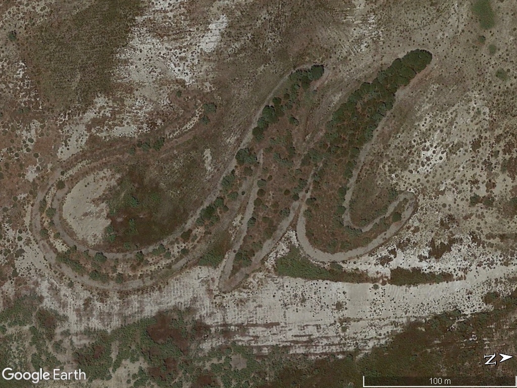
An M or a squiggle 40.210253° 16.724194°
|
|
Master Gamer
April 2018 - Dec 4, 2024 20:57:55 GMT
|
Post by willi1 on Feb 20, 2024 20:55:31 GMT
They planted a seahorse there 50.965864° 14.726646°
|
|
Master Cartographer
April 2015 - Dec 4, 2024 20:55:47 GMT
|
Post by syzygy on Feb 21, 2024 7:33:02 GMT
They planted a seahorse there 50.965864° 14.726646°
Again I think this is a natural hollow, unsuitable for agricultural cultivation, covered with naturally settled plants. The shadows by low sun angle make the seahorse shape the most apparent on your screenie. Still it will worth a "Willi's seahorse" placemark in the collection after the next file update! ( ; ... Oh, and the previous "M" for Marinagri Hotel & Spa ... ( ; Many thanks for your great additions! -- Updated kmz file attached to OP. |
|
Master Gamer
April 2018 - Dec 4, 2024 20:57:55 GMT
|
Post by willi1 on May 1, 2024 20:10:33 GMT
Victory? 50.900489° -0.083823°
|
|
Master Cartographer
April 2015 - Dec 4, 2024 20:55:47 GMT
|
Post by syzygy on May 2, 2024 6:38:59 GMT
Almost.. - it "was planted for Queen Victoria's Royal Golden Jubilee.. in 1897." / source: sussexlive.co.uk Follow link for great photos and detailed informations about the site! Much thanks for this "V" as Valuable contribution! ( : -- Updated kmz file attached to OP. 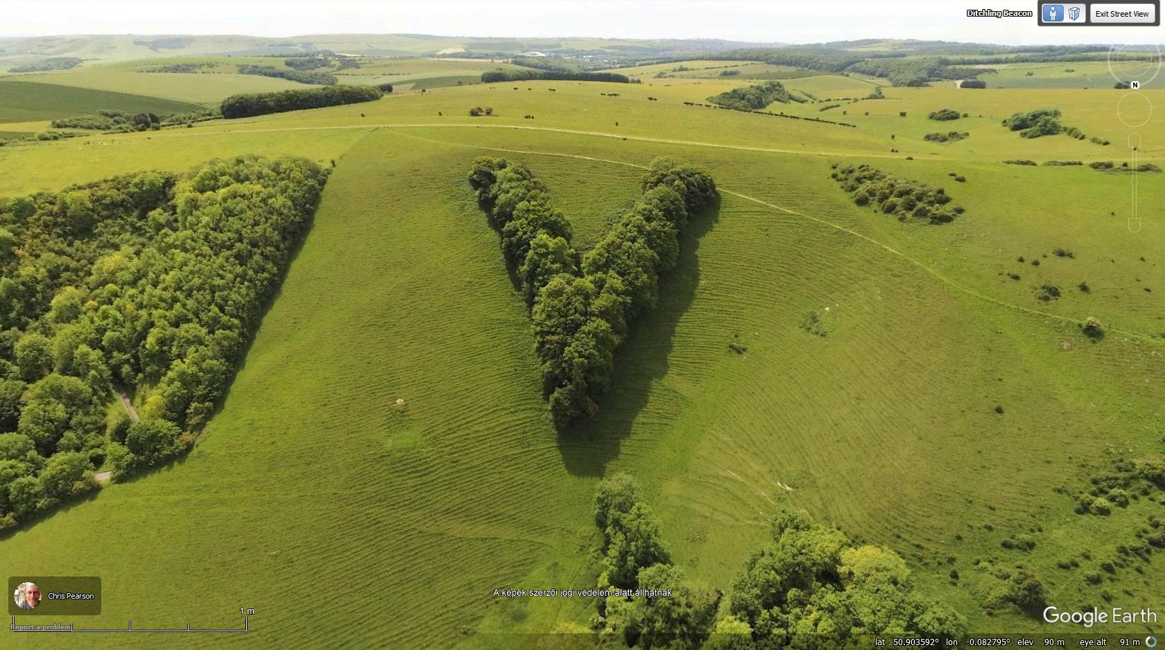 Placemark default view set to GE BlueDot aerial photo by Chris Pearson |
|
Master Cartographer
April 2015 - Dec 4, 2024 20:55:47 GMT
|
Post by syzygy on Jun 24, 2024 15:10:08 GMT
Nr.94.Artistic plantations around an ancient pyramidal mound from China  ---------------------------------------------------------------------------------------------------------------------------->> 34.381892, 109.253910<< Tomb of Emperor Qin ErshiQin dynasty mausoleum / Tomb of First Emperor in Lintong This is the largest Chinese burial mound. The original height was 76 metres, the present height is 47 metres. It was built during the short-lived imperial Qin dynasty (221–206 BCE). source: en.wikipedia.org/wiki/Chinese_pyramids -- Updated kmz file attached to first post of this forum thread!-- Placemarks for 60+ pyramidal mound sites available. - - Check kmz file attached to this posting: googleearthcommunity.proboards.com/thread/3949/mounds-earth
|
|
Master Cartographer
April 2015 - Dec 4, 2024 20:55:47 GMT
|
Post by syzygy on Jun 26, 2024 11:42:49 GMT
2 more interesting (yet unsolved) plantations from Russia: No.95.: Unreadable, still it looks like as if were some (cyrillic?) text. - Ideas welcome!  >>54.76889, 89.93604<< No.96.: Some kind of a symbol(?) nearby. - Anyone with a guess?  >>54.78080, 89.93603<< And another chinese characters plantation site from China: No.97.: Three characters in the SW, NW and NE sections of the plot. - Anyone with a solving?  >>39.27942, 115.61895<< Thanks! -- Updated kmz file attached to OP. |
|
Master Cartographer
April 2015 - Dec 4, 2024 20:55:47 GMT
|
Post by syzygy on Jun 27, 2024 8:00:20 GMT
No.98.source: independent.co.uksource2: forestryengland.uk - with detailed informations and GDrive gallery. -- New growth still not strong enough on 2022 and 2023 GE imagery, but faint contours of the eye just visible. Hardly can wait for the next imagery update of the area...! ( ;  GMaps link GMaps link to 2023 imagery at >> 54.2783745, -0.6733482<< --
Updated kmz file attached to OP.
|
|
Master Gamer
April 2018 - Dec 4, 2024 20:57:55 GMT
|
Post by willi1 on Aug 11, 2024 19:42:11 GMT
Created to celebrate the 850th anniversary of Munich (Germany).  Attachments:850 Mnchen.kmz (683 B)
|
|
Master Cartographer
April 2015 - Dec 4, 2024 20:55:47 GMT
|
Post by syzygy on Aug 12, 2024 14:52:29 GMT
Nr.99.Created to celebrate the 850th anniversary of Munich (Germany). Thanks for this nice contribution as the 99th piece of the collection! -- Updated kmz file attached to OP!
|
|
Master Cartographer
April 2015 - Dec 4, 2024 20:55:47 GMT
|
Post by syzygy on Aug 23, 2024 11:11:03 GMT
For jubilee Nr.100. here we go with an oldie but goodie: -- Complex triangular pattern East of Blackwater National Wildlife Refuge, South of Cambridge, Maryland, USA. Inner spaces can be filled with water (check time slider) so maybe it is some kind of a fishing/hunting/recreational/wildlife...(?) facility. - Any trustable infos welcome!  >> 38.45458, -75.97338<< 1st spotting credit: Joe_Gottschall (oGEC-2006) -- Updated kmz file attached to OP. |
|
Master Cartographer
April 2015 - Dec 4, 2024 20:55:47 GMT
|
Post by syzygy on Sept 12, 2024 12:04:34 GMT
Nr.101Circular forest park with 8 pathways leading to an old, solitary oak tree "De Eenzame Eik" in the centre.  >> 52.00556, 5.48762<< Netherlands - Utrecht Utrechtse Heuvelrug Amerongen --
Updated kmz file attached to Original Post.
|
|
Master Cartographer
April 2015 - Dec 4, 2024 20:55:47 GMT
|
Post by syzygy on Oct 7, 2024 12:24:50 GMT
Nr.102. - BISMARCK (ND, USA)  >>46.81560, -100.72276<< "Planted in July 1972, the Bismarck Centennial Forest was erected to celebrate the 100th anniversary of the city." source: Instagram @nearmap-- Nr.103. - Herzapfelhof (Germany)  >>53.52646, 9.69665<< "Apple-shaped farm outside of Hamburg, Germany. Herzapfelhof was planted with 250 old-varieties of apples. You can pick your own and enjoy the crisp weather of Altes Land, the largest contiguous apple-growing region in Europe." / George Steinmetz source: Instagram @geosteinmetz-- Nr.104. - "Seven corner round forest" (Romania)  >>44.35019, 26.04891<< Horia Hulubei National Institute of Physics and Nuclear Engineering - The round forest presumably was planted for protection zone purposes. (?) --
Updated kmz file attached to OP.
|
|
Master Gamer
April 2018 - Dec 4, 2024 20:57:55 GMT
|
Post by willi1 on Nov 11, 2024 20:47:24 GMT
ПETP is a Russian first name meaning Peter. Found in Krasnoyarsk. Attachments:Krasnojarsk.kmz (685 B)
|
|
Master Cartographer
April 2015 - Dec 4, 2024 20:55:47 GMT
|
Post by syzygy on Nov 12, 2024 8:06:33 GMT
Nr.105.ПETP is a Russian first name meaning Peter. Found in Krasnoyarsk. Also there are some stuff in GE layers - Places / Photos - and this is an apple garden. Russian brother of Nr.103. from Germany... ( : Great spotting, thanks for the very nice contribution again! -- Updated kmz file attached to OP.
|
|
Master Gamer
April 2018 - Dec 4, 2024 20:57:55 GMT
|
Post by willi1 on Nov 26, 2024 20:52:57 GMT
|
|
Master Cartographer
April 2015 - Dec 4, 2024 20:55:47 GMT
|
Post by syzygy on Nov 26, 2024 22:13:57 GMT
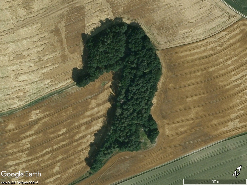
Nr.106.A Minnesota-shaped forest More precisely "The 2nd Minnesota-shaped forest"Great addition to the collection, just as it was by your 1st Minnesota-shaped forest bro!  ( ; Thanks for excellent contribution again! --
Updated kmz file attached to OP.
|
|




 ( ;
( ;