Master Gamer
April 2018 - Dec 4, 2024 20:57:55 GMT
|
Post by willi1 on Sept 17, 2020 10:07:13 GMT
A woman, clearly 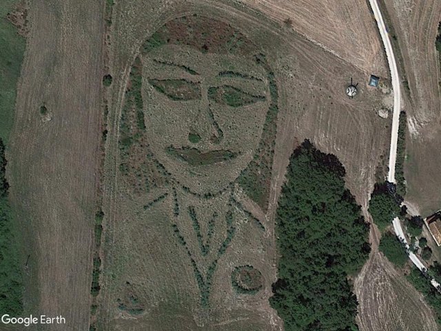 Attachments:Face.kmz (779 B)
|
|
Master Cartographer
April 2015 - Dec 4, 2024 20:55:47 GMT
|
Post by syzygy on Sept 17, 2020 10:16:11 GMT
... Made of shrubs and smaller trees. Wery well spotted! Thanks! |
|
Master Gamer
April 2018 - Dec 4, 2024 20:57:55 GMT
|
Post by willi1 on Oct 10, 2020 11:23:13 GMT
A Emu at Ceduna, South Australia
Attachments:Emu.kmz (709 B)
|
|
Master Cartographer
April 2015 - Dec 4, 2024 20:55:47 GMT
|
Post by syzygy on Oct 10, 2020 18:10:41 GMT
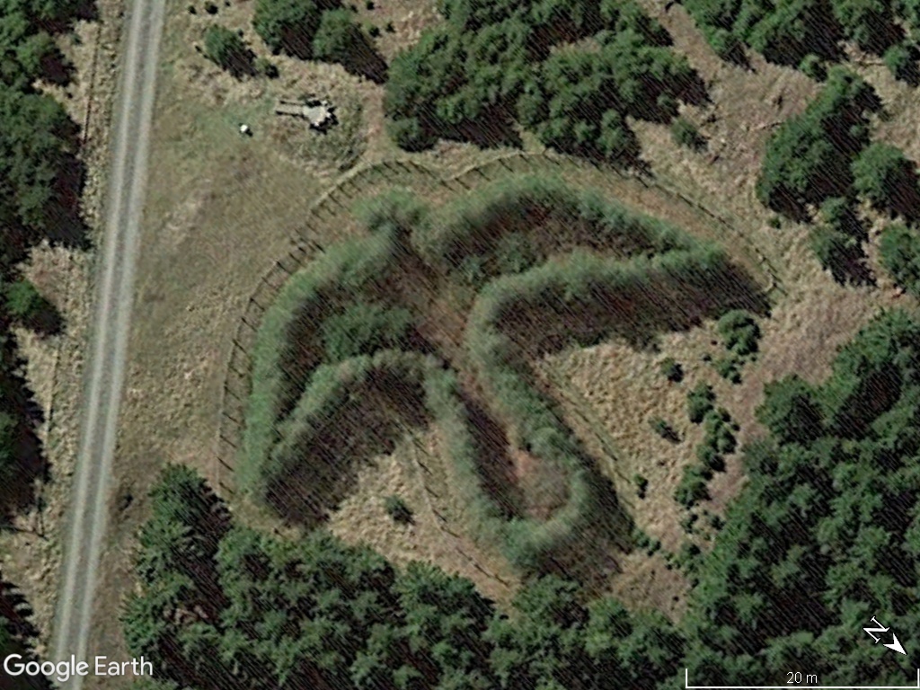
A Emu at Ceduna, South Australia
cool man! B) Don't you have any info on this? Seem to be a pasture, where animal grazing - could this be a clue for what kind of livestock is that? (: |
|
Master Gamer
April 2018 - Dec 4, 2024 20:57:55 GMT
|
Post by willi1 on Oct 10, 2020 18:59:01 GMT
Found it by accident while searching for airplanes. And now I've found something to do with it. It's an emu farm on the Aboriginal Corporation's land.
|
|
Cartographer
April 2015 - Nov 12, 2024 14:28:33 GMT
“ Armchair Traveller - Love to Roam Google Streets - 8 Star Local Guide of Google Maps „
|
Post by CuriousJM on Dec 27, 2020 13:50:10 GMT
Seasons Greetings and Happy New Year. Found this Mysterious Chalice with an Arrow in Florida, Uruguay. It is named Caliz de Florida, Uruguay. Made of trees, it is 488 meters long and 235 meters wide. More information at viajes.elpais.com.uyCoordinates: -34.2229845,-56.3656664 Google Maps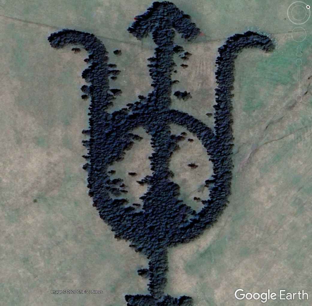 |
|
Master Cartographer
April 2015 - Dec 4, 2024 20:55:47 GMT
|
Post by syzygy on Dec 27, 2020 18:22:12 GMT
Thanks this great example CuriousJM ! Now we are over 70 placemarks with this one! As one can read on Gmaps comments it is the cattle marking on those pastures. Was planted by the local farmer some 60 years ago. It is a plantation of eucalyptus trees. Also great aerial photos there! *** Updated kmz folder attached to OP. *** Greetings and Happy New Year! |
|
Cartographer
April 2015 - Nov 12, 2024 14:28:33 GMT
“ Armchair Traveller - Love to Roam Google Streets - 8 Star Local Guide of Google Maps „
|
Post by CuriousJM on Jan 31, 2021 17:31:25 GMT
The Green Cathedral, near Almere, Netherlands.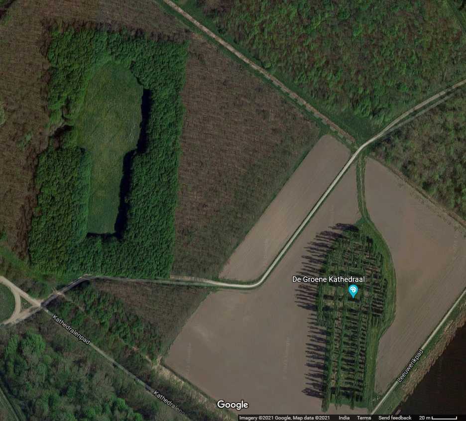 As per Wikipedia; "The Green Cathedral or De Groene Kathedraal located near Almere, the Netherlands, is an artistic planting of Lombardy poplars (Populus nigra italica) that mimics the size and shape of the Cathedral of Notre-Dame, Reims, France. The Green Cathedral is 150 m (490 ft) long and 75 m (246 ft) wide, and the mature poplar trees are about 30 m (98 ft) tall.
The work was planted by Marinus Boezem (b. 1934) on April 16, 1987, in Southern Flevoland. The land art project was installed on polder land; 178 trees were planted on a knoll, a half-metre above the surrounding area. Over the following years, some trees were replaced due to deer damage, and stone was laid in the floor to echo the cross ribs and support beams of the cathedral.
Now mature, the cathedral has become a location for weddings, funerals, meetings, and religious services of all kinds.[1] Nearby, a clearing has been made in a young beech forest so that the open space is in the shape of the same cathedral. Boezem suggests, as the poplars decline, the beech trees around the clearing will grow to create the church once more, thus ensuring a cyclical evolution of growth, decline, and growth."Coordinates: 52.323157°,5.318778° Google MapsNote: This work of art was placemarked twice in now defunct (old) GEC.
|
|
Master Cartographer
April 2015 - Dec 4, 2024 20:55:47 GMT
|
Post by syzygy on Feb 1, 2021 8:09:08 GMT
... Note: This work of art was placemarked twice in now defunct (old) GEC. And now I gonna stick the 3rd pushpin here around this functioning board of the GEC! ( : Only I will mention also Circle-forest ( Cirkelbos) on the other side of the road. If you zoom out of the exact Cathedral plantation, you will see that all the surrounding area is built up of artistically plantated forest blocks. If you also check GE / Layers / More / Parks, you will see that the forest on the North-bank of the channel is called "Cathedral Forest" (Kathedralenbos), while woodland on the South-bank is "Circle Forest". 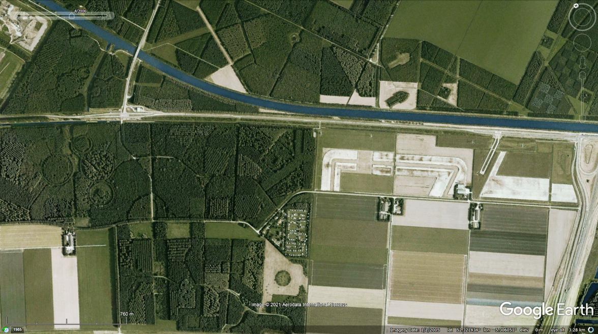 Thank you for this interesting site again CJM Master! ( ; --- Updated kmz file attached to OP. |
|
Master Gamer
April 2018 - Dec 4, 2024 20:57:55 GMT
|
Post by willi1 on Feb 25, 2021 10:00:33 GMT
Ragley Park ( Alcester, Warwickshire, UK)
Could be 300, indicating Ragley Hall was built in 1683.
Attachments:300.kmz (676 B)
|
|
Master Cartographer
April 2015 - Dec 4, 2024 20:55:47 GMT
|
Post by syzygy on Feb 25, 2021 13:03:50 GMT
...Could be 300, indicating Ragley Hall was built in 1683. ... Cool new piece! Thank you Willie! --- Added to kmz collection attached to OP. |
|
Master Gamer
April 2018 - Dec 4, 2024 20:57:55 GMT
|
Post by willi1 on Apr 29, 2021 10:36:42 GMT
A world map - intent or coincidence?
Attachments:The World.kmz (782 B)
|
|
Master Cartographer
April 2015 - Dec 4, 2024 20:55:47 GMT
|
Post by syzygy on Apr 29, 2021 14:30:14 GMT
A world map - intent or coincidence? Faint resemblance of Earth's continents also it is situated on the northern slopes of the same hills where our Italy plantation can be found, only that one is on the southern slopes. Many GE Layer markers without a mention of such "continents" plantation... 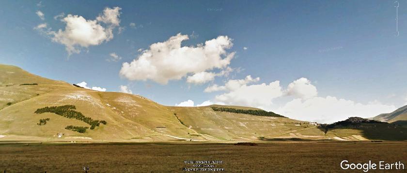  This means, your "World map" is visible from the ground only from the northern valley and it can be seen upside down this way. All these make me say, this time your eyes have made tricks on you!  |
|
Master Gamer
April 2018 - Dec 4, 2024 20:57:55 GMT
|
Post by willi1 on May 25, 2021 15:55:01 GMT
|
|
Master Cartographer
April 2015 - Dec 4, 2024 20:55:47 GMT
|
Post by syzygy on May 25, 2021 16:03:31 GMT
What a great piece! Thank you master willi1 ! Great to see with GE time-slider the growth and how the clumps get more dense as time passes. ... Updated kmz file attached to OP. |
|
Master Gamer
April 2018 - Dec 4, 2024 20:57:55 GMT
|
Post by willi1 on Jun 20, 2021 12:08:45 GMT
|
|
Master Gamer
April 2018 - Dec 4, 2024 20:57:55 GMT
|
Post by willi1 on Aug 9, 2021 9:14:53 GMT
|
|
Master Gamer
April 2018 - Dec 4, 2024 20:57:55 GMT
|
Post by willi1 on Nov 11, 2021 15:44:01 GMT
Is this spider coincidence or intention ? Attachments:Spider.kmz (779 B)
|
|
Master Cartographer
April 2015 - Dec 4, 2024 20:55:47 GMT
|
Post by syzygy on Nov 11, 2021 17:03:31 GMT
Is this spider coincidence or intention ? The basic shapes are given by natural formations however plantation and some dig work could help a bit... Great spotting anyhow!  Until further info comes in I'll list this one as "willi1's spider" in the collection. *** Updated kmz file attached to OP. |
|
Master Gamer
April 2018 - Dec 4, 2024 20:57:55 GMT
|
Post by willi1 on Dec 19, 2021 12:23:52 GMT
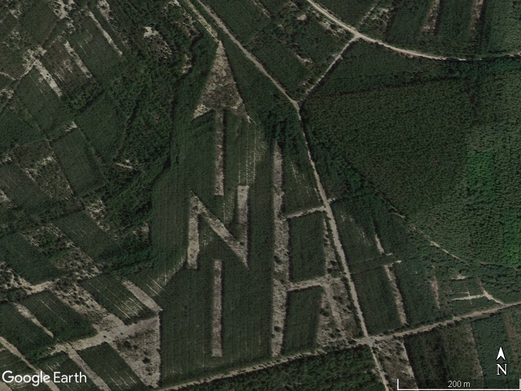
A N, a Star and the shape of Minnesota and other shapes near Sandstone (Minnesota)
Attachments:Minnesota.kmz (795 B)
|
|
Master Cartographer
April 2015 - Dec 4, 2024 20:55:47 GMT
|
Post by syzygy on Mar 23, 2022 9:04:14 GMT
Just have re-discovered this coastal sharky at Old Bar, Wallabi Point, on half-way from Canberra to Brisbane*:  Coordinates: >>-31.9889091, 152.5722299<< Coordinates: >>-31.9889091, 152.5722299<<-- Some infos available on GE / GEC layer - (spotting history): -- Updated kmz file attached to OP! (Also previous spotting by willi1 included.) -- *p.s.: Sorry, I just cannot stand not to share the only joke I know with the keyword 'Brisbane'. (18+ content! - text hidden, wrapped well in a kmz file) ... ( : -- note: Afterall thread status turned to 'hot'...( ; |
|
Master Gamer
April 2018 - Dec 4, 2024 20:57:55 GMT
|
Post by willi1 on Apr 24, 2022 10:05:06 GMT
This tree patterns are a part of the Ferne Park near Shaftesbury, UK Attachments:Treepatterns UK.kmz (856 B)
|
|
Master Gamer
April 2018 - Dec 4, 2024 20:57:55 GMT
|
Post by willi1 on Nov 20, 2022 18:58:27 GMT
To commemorate the Battle of Grunwald (Battle of Žalgiris) in 1410, the lettering (Žalgiris 600) was planted in Bezdonys (Lithuania). 54.800887° 25.529747°
|
|
Master Gamer
April 2018 - Dec 4, 2024 20:57:55 GMT
|
Post by willi1 on Aug 10, 2023 13:54:02 GMT
Only good to visible in autumn ( Hampton Lumber timberland, Oregon) 45.041334° -123.520900° |
|
Master Gamer
April 2018 - Dec 4, 2024 20:57:55 GMT
|
Post by willi1 on Sept 7, 2023 9:44:29 GMT
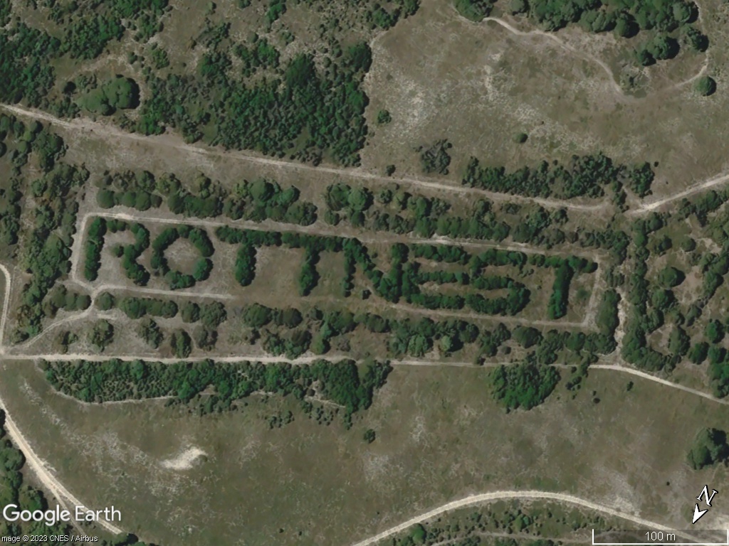
On Rottnest Island (Australia) -32.008873° 115.525275°
|
|
Master Cartographer
April 2015 - Dec 4, 2024 20:55:47 GMT
|
Post by syzygy on Sept 8, 2023 10:29:43 GMT
On Rottnest Island (Australia) -32.008873° 115.525275°
It is waiting on my to do list for a longer while now... Once I do the file update then it will be booked as your addition! ( ; Thanks for all your great contributions! |
|
Master Gamer
April 2018 - Dec 4, 2024 20:57:55 GMT
|
Post by willi1 on Nov 23, 2023 21:06:59 GMT
Peace - more relevant than ever 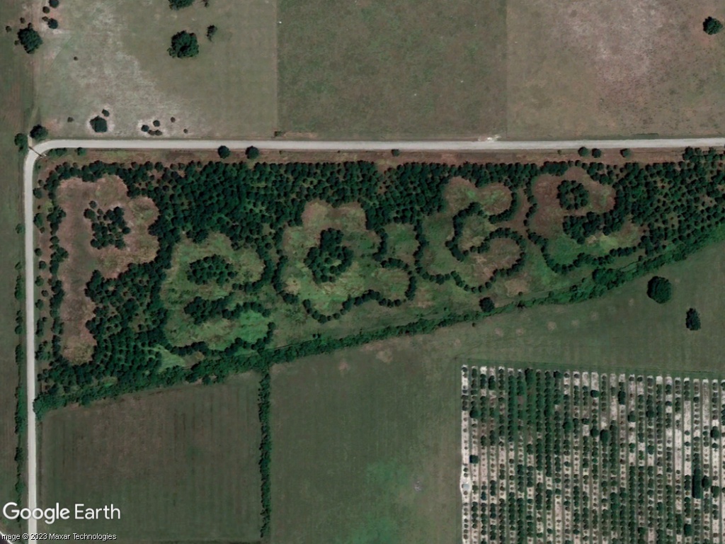 27.372889° -81.983262° (4/2019)
|
|
Master Gamer
April 2018 - Dec 4, 2024 20:57:55 GMT
|
Post by willi1 on Dec 19, 2023 16:10:04 GMT
A falcon in flight 51.109526° 8.377851°
|
|
Master Cartographer
April 2015 - Dec 4, 2024 20:55:47 GMT
|
Post by syzygy on Dec 19, 2023 17:00:55 GMT
Awesome! Much thanks willi1 for your great additions!  Updated kmz file attached to OP! Updated kmz file attached to OP!Keep up the good work! Happy holydays! |
|
Master Gamer
April 2018 - Dec 4, 2024 20:57:55 GMT
|
Post by willi1 on Jan 16, 2024 21:00:40 GMT
For planes from Poland to the North Pole 50.247036° 19.417234°
|
|





 - 7 Message(s)


