

I might have found a lost town (Tarra/Zara follow-up thread)
Aug 18, 2023 4:55:28 GMT
krenek and syzygy like this
Post by thazz on Aug 18, 2023 4:55:28 GMT
Hey, I'm Thazz,
If you haven't seen my last post on the Tarra/Zara mystery, please read it here if you haven't already: link
This title might sound a bit crazy I know, but hear me out please! I need your opinions!
(Also sorry for the new post on this, I figured I wouldn't get much of attention if I had made a follow-up on my original post since it's been like a month, if you want me to move this into a comment though on my original thread, I'll do so. However, I think this should be a new thread anyways, since we are analyzing evidence rather than trying to find it)
----------
ANYWAYS! Let's get my theory and why I think I possibly found Tarra and/or Zara. I don't like drawing out my forum posts, so I'm just going to show you where I think it is first so you have that for context on what I'm going to show later down the line:
Coords: 18.4881607 -11.3789319
KML: res.cloudinary.com/drbrq1k3e/raw/upload/v1692329099/user_uploads/standard/ex7lcmod3hjes2e0gfdr.kml
I've had these ruins in my KML on medieval Saharan towns for a while before I even started my research on Tarra & Zara. I just happened to stumble upon the ruins while I was surveying/following the dried up river next to it out of boredom. I tried to identify it, but all my leads turned up dry, so I just gave up and left it 'unknown'. If you can find any other identification as to the name or origin of these ruins, please reply!
Nevertheless, let's get into my reasoning as to why this is probably Tarra, I don't like to make you read.
----------
Reasoning 1: Comparison
OK, this was my first reasoning and the reason I dug deeper into these ruins as being the possible location of Tarra. To begin, these ruins' "architectural style" match up well with other ruins of the same supposed time period (14th-17th century), here's some examples to cross-reference:
Fig 1. "Tarra"
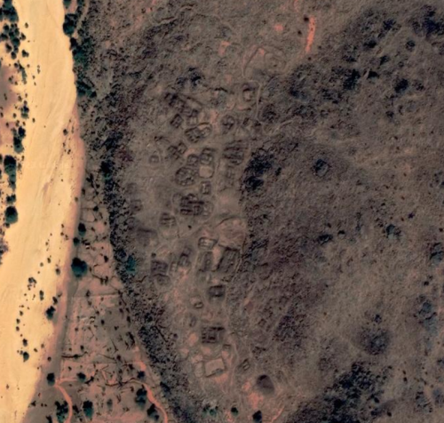
Fig 2. Tinigui/Tinigi [20.7396004 -12.0026458]

Fig 3. Togba (zoomed in due to blurry imagery) [17.390826 10.3551774]

Can you see the resemblance between the ruins? How the buildings are divided into 'E' looking shapes? If that's not enough to convince you, that's fine, it wasn't enough for me either, which is why I give you...
----------
Reasoning 2: Location
Let's go back to the map I referenced in my last forum post, taken from one of the two sources I found that referenced Tarra, the book The Atlantic World and Virginia, 1550-1624.

Take note of the positions of both Togba and Tinigi, as they are cross-referenced in the image below.

I tried my best to line it up, but the earth is a globe and I don't feel like using Google Maps because I want to put out this post ASAP.
Close though, isn't it? Well, that's only the start because the next section is heavy just to warn you...
----------
Reasoning 3: Documentation
As I stated previously, I only ever found 2 sources that referenced and/or talked about the mystery of Tarra. Those being The Atlantic World and Virginia, 1550-1624 and The Quest for "Tarra": Toponymy and Geography in Exploring History, the latter having been provided to me by forum user bemerkenswelt (thank you so much by the way that was very kind of you and I appreciated it a lot).
Anyhow, the first part of The Quest for Tarra that hinted in the direction of my theoretical location was this paragraph, suggesting that Tarra could possibly be the town of Tidjikja, only 6 miles north up the river from our location of analysis:
(The text previously talked about how the name Tarra can possibly mean forest, just to give context)
"From the point of view of location (in a forested area in "Moores Countrey") and trade (it could well have been the receptor of the legendary Shinqit-Tishit salt caravan), Tidjikja is a viable possibility. From the point of view of name, it fits both the possibility of tahra, a resting place in the sandy soiled wadi Tidjikja, and ziyarah, the location of the tomb of venerated Almoravid leader Abu Bakr b. Umar."
The text then goes on about how Tarra could also be Togba, but it holds no bearing in this thread. However, the author does go back to Tidjikja when they reference a first-hand account's approximate distance of Tarra from "Bambuk":
"One trail remains to be followed, namely "Tarra's" supposed distance from Hodges' position in Bambuk. To recall, he reported this to be "better yn 300 miles ENE." According to Curtin, whose identification has gone unquestioned to date, "by dead reckoning from modern maps, that would put [Tarra] between Nioro and Jaara (Diara) in Mali. It is possible that ... [it] was actually the present-day Jarra, or else Nara, somewhat further east." In fact, this distance on modern maps takes us well beyond the Nioro-Jara region. By dead reckoning, a radius of 300 miles reaches Tidjikja, the eastern Hodh and Nara, encompassing the Togba region located at some 250-260 miles east-north-east"
The author then questions the measurement of 300 miles, as the sources given talks about how another researcher says that Hodges' texts exaggerated the distance by 2.2x. HOWEVER, the author goes back on himself again, stating how there would be no reason for Hodges to do so. So we're brought back full circle. The author further cites this map which is very helpful:
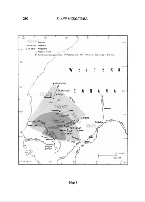
There's another page after the map which is basically just calculations on the distance, however, it's very inconclusive, and is only there to provide another possible number, not to deny all others. All in all, the author never confirms or denies that 300 miles may be the right distance, so it is not off the table.
----------
Welp that's about it. I know this is a pretty hefty post, but I want your guys' opinions: yea or nah? I certainly think its a possibility, and if it's confirmed as some other town, hey, that's another name for my map. Thank you for reading. Please comment, even if you don't have anything useful to say. I want to know if I actually reached anyone
If you haven't seen my last post on the Tarra/Zara mystery, please read it here if you haven't already: link
This title might sound a bit crazy I know, but hear me out please! I need your opinions!
(Also sorry for the new post on this, I figured I wouldn't get much of attention if I had made a follow-up on my original post since it's been like a month, if you want me to move this into a comment though on my original thread, I'll do so. However, I think this should be a new thread anyways, since we are analyzing evidence rather than trying to find it)
----------
ANYWAYS! Let's get my theory and why I think I possibly found Tarra and/or Zara. I don't like drawing out my forum posts, so I'm just going to show you where I think it is first so you have that for context on what I'm going to show later down the line:
Coords: 18.4881607 -11.3789319
KML: res.cloudinary.com/drbrq1k3e/raw/upload/v1692329099/user_uploads/standard/ex7lcmod3hjes2e0gfdr.kml
I've had these ruins in my KML on medieval Saharan towns for a while before I even started my research on Tarra & Zara. I just happened to stumble upon the ruins while I was surveying/following the dried up river next to it out of boredom. I tried to identify it, but all my leads turned up dry, so I just gave up and left it 'unknown'. If you can find any other identification as to the name or origin of these ruins, please reply!
Nevertheless, let's get into my reasoning as to why this is probably Tarra, I don't like to make you read.
----------
Reasoning 1: Comparison
OK, this was my first reasoning and the reason I dug deeper into these ruins as being the possible location of Tarra. To begin, these ruins' "architectural style" match up well with other ruins of the same supposed time period (14th-17th century), here's some examples to cross-reference:
Fig 1. "Tarra"
Fig 2. Tinigui/Tinigi [20.7396004 -12.0026458]
Fig 3. Togba (zoomed in due to blurry imagery) [17.390826 10.3551774]
Can you see the resemblance between the ruins? How the buildings are divided into 'E' looking shapes? If that's not enough to convince you, that's fine, it wasn't enough for me either, which is why I give you...
----------
Reasoning 2: Location
Let's go back to the map I referenced in my last forum post, taken from one of the two sources I found that referenced Tarra, the book The Atlantic World and Virginia, 1550-1624.
Take note of the positions of both Togba and Tinigi, as they are cross-referenced in the image below.
I tried my best to line it up, but the earth is a globe and I don't feel like using Google Maps because I want to put out this post ASAP.
Close though, isn't it? Well, that's only the start because the next section is heavy just to warn you...
----------
Reasoning 3: Documentation
As I stated previously, I only ever found 2 sources that referenced and/or talked about the mystery of Tarra. Those being The Atlantic World and Virginia, 1550-1624 and The Quest for "Tarra": Toponymy and Geography in Exploring History, the latter having been provided to me by forum user bemerkenswelt (thank you so much by the way that was very kind of you and I appreciated it a lot).
Anyhow, the first part of The Quest for Tarra that hinted in the direction of my theoretical location was this paragraph, suggesting that Tarra could possibly be the town of Tidjikja, only 6 miles north up the river from our location of analysis:
(The text previously talked about how the name Tarra can possibly mean forest, just to give context)
"From the point of view of location (in a forested area in "Moores Countrey") and trade (it could well have been the receptor of the legendary Shinqit-Tishit salt caravan), Tidjikja is a viable possibility. From the point of view of name, it fits both the possibility of tahra, a resting place in the sandy soiled wadi Tidjikja, and ziyarah, the location of the tomb of venerated Almoravid leader Abu Bakr b. Umar."
The text then goes on about how Tarra could also be Togba, but it holds no bearing in this thread. However, the author does go back to Tidjikja when they reference a first-hand account's approximate distance of Tarra from "Bambuk":
"One trail remains to be followed, namely "Tarra's" supposed distance from Hodges' position in Bambuk. To recall, he reported this to be "better yn 300 miles ENE." According to Curtin, whose identification has gone unquestioned to date, "by dead reckoning from modern maps, that would put [Tarra] between Nioro and Jaara (Diara) in Mali. It is possible that ... [it] was actually the present-day Jarra, or else Nara, somewhat further east." In fact, this distance on modern maps takes us well beyond the Nioro-Jara region. By dead reckoning, a radius of 300 miles reaches Tidjikja, the eastern Hodh and Nara, encompassing the Togba region located at some 250-260 miles east-north-east"
The author then questions the measurement of 300 miles, as the sources given talks about how another researcher says that Hodges' texts exaggerated the distance by 2.2x. HOWEVER, the author goes back on himself again, stating how there would be no reason for Hodges to do so. So we're brought back full circle. The author further cites this map which is very helpful:
There's another page after the map which is basically just calculations on the distance, however, it's very inconclusive, and is only there to provide another possible number, not to deny all others. All in all, the author never confirms or denies that 300 miles may be the right distance, so it is not off the table.
----------
Welp that's about it. I know this is a pretty hefty post, but I want your guys' opinions: yea or nah? I certainly think its a possibility, and if it's confirmed as some other town, hey, that's another name for my map. Thank you for reading. Please comment, even if you don't have anything useful to say. I want to know if I actually reached anyone


