Seahenge - A Remarkable Prehistoric Wooden Circle
Mar 10, 2023 17:08:39 GMT
Walter_V_R, krenek, and 1 more like this
Post by CuriousJM on Mar 10, 2023 17:08:39 GMT
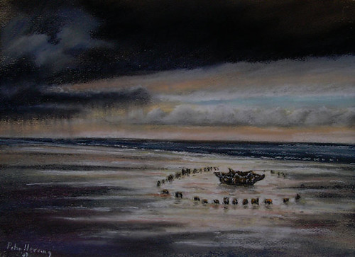
In 1998, a remarkable archaeological find was made on the beach at Holme-next-the-Sea, a small village in North Norfolk, England. As the salt marsh eroded and the sands shifted, the remains of a timber circle were revealed. This unique structure consisted of 55 closely-fitted oak posts, arranged in a circle with a 6.6-meter (21 ft.) diameter and a large upturned tree stump at the centre. Each oak post was approximately 3m (10 ft) high, while the central stump was 2.5m (8ft) wide and weighed roughly a tonne.
Commonly known as "Seahenge", the structure, officially named "Holme I" is estimated to have been constructed over 4000 years ago during the early Bronze Age. It is believed that around 15 to 20 oak trees were felled circa 2049 BC to create the 55 posts and the central stump, with bronze axes potentially used to cut and shape the wood.
Archaeologists and historians speculate that those who farmed close to the salt marshes and lived nearby built the circle. Some theories suggest that it served as a basic astronomical calendar, indicating the midwinter sunset and midsummer sunrise. Others suggest that it was a location for local rites, or to commemorate the passing of a chieftain, or it may even be the burial place of a chieftain.
Initially, the site was situated far from the sea and protected by thick layers of peat and sand. However, over time, the sea encroached upon the area and washed away the protective cover, causing the timber to decay. The corrosive effects of seawater salts, the burrowing activities of wood-boring molluscs and worms, and the repeated wetting and drying caused by the tides, contributed to the deterioration of the wooden posts and stump. When discovered, the timber was in a state of decay. To preserve the wooden posts and the stump, they were excavated, cleaned, and subjected to complex conservation treatments before being coated with special wax and polyethylene glycol (PEG).
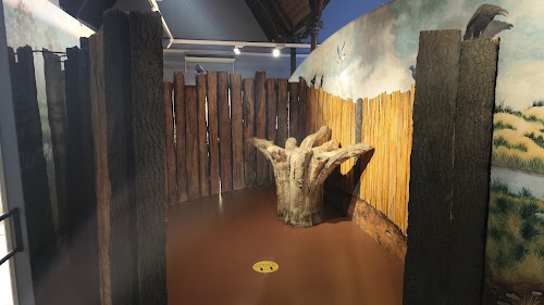
Currently, half of the timber posts and the central stump are on permanent display in the Lynn Museum at King's Lynn. Initially, the removal of the stumps and central trunk from the original location was met with objections from locals. Ultimately, however, the archaeologists and heritage groups prevailed, and the planks and stumps were removed from the original site.
A year after the discovery of Seahenge, a second and a larger circle, called Holme II, was found approximately 100 meters (328 ft.) away from the original site. This circle had a diameter of 13.2 meters (43 ft.) and had two oak logs at its centre. The second circle was also built around 2049 BC, the same time as the first. After studying it, archaeologists decided to leave it in-situ, and it gradually decayed. Today, there are no remnants of this circle.

Image from Flickr is by Hornbeam Arts

Seahenge at the Lyn Museum.

Image from Google Maps is by Vidmantas Grikstas

Image from Google Maps is by Jocelyn Twose
Holme II (1999)

Google Street View (Inside Lyn Museum)
Location of original site in Google Maps (Seahenge is not visible in GE imagery. The location is based on the placemarker created by Andy Megalithic in Google Earth.)
Source of information and more information: artsandculture.google.com / Wikipedia
Copyright: The images displayed here are the property of their respective owners, and the copyright information is available via the link provided below each image.
Commonly known as "Seahenge", the structure, officially named "Holme I" is estimated to have been constructed over 4000 years ago during the early Bronze Age. It is believed that around 15 to 20 oak trees were felled circa 2049 BC to create the 55 posts and the central stump, with bronze axes potentially used to cut and shape the wood.
Archaeologists and historians speculate that those who farmed close to the salt marshes and lived nearby built the circle. Some theories suggest that it served as a basic astronomical calendar, indicating the midwinter sunset and midsummer sunrise. Others suggest that it was a location for local rites, or to commemorate the passing of a chieftain, or it may even be the burial place of a chieftain.
Initially, the site was situated far from the sea and protected by thick layers of peat and sand. However, over time, the sea encroached upon the area and washed away the protective cover, causing the timber to decay. The corrosive effects of seawater salts, the burrowing activities of wood-boring molluscs and worms, and the repeated wetting and drying caused by the tides, contributed to the deterioration of the wooden posts and stump. When discovered, the timber was in a state of decay. To preserve the wooden posts and the stump, they were excavated, cleaned, and subjected to complex conservation treatments before being coated with special wax and polyethylene glycol (PEG).
Currently, half of the timber posts and the central stump are on permanent display in the Lynn Museum at King's Lynn. Initially, the removal of the stumps and central trunk from the original location was met with objections from locals. Ultimately, however, the archaeologists and heritage groups prevailed, and the planks and stumps were removed from the original site.
A year after the discovery of Seahenge, a second and a larger circle, called Holme II, was found approximately 100 meters (328 ft.) away from the original site. This circle had a diameter of 13.2 meters (43 ft.) and had two oak logs at its centre. The second circle was also built around 2049 BC, the same time as the first. After studying it, archaeologists decided to leave it in-situ, and it gradually decayed. Today, there are no remnants of this circle.

Image from Flickr is by Hornbeam Arts
Seahenge at the Lyn Museum.
Image from Google Maps is by Vidmantas Grikstas
Image from Google Maps is by Jocelyn Twose
Holme II (1999)
Google Street View (Inside Lyn Museum)
Location of original site in Google Maps (Seahenge is not visible in GE imagery. The location is based on the placemarker created by Andy Megalithic in Google Earth.)
Source of information and more information: artsandculture.google.com / Wikipedia
Copyright: The images displayed here are the property of their respective owners, and the copyright information is available via the link provided below each image.

