Junior Member
September 2021 - Sept 23, 2024 14:04:01 GMT
|
Post by buildsancient on Oct 21, 2022 10:24:23 GMT
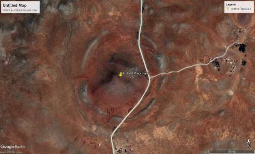
Hi guys. Any idea of what this might be? It is roughly 500m wide and 20m high in the centre. GE won't pick up the outer ring ad it is below the 30m STRM. Position is: 37°43'51.60"N 39°49'52.35"E I don't think it is volcanic or an impact crater. So I was thinking maybe something like a Kurgan? If so, this is pretty darned big.  Enjoy! |
|
Master Cartographer
April 2015 - Nov 25, 2024 16:17:21 GMT
|
Post by syzygy on Oct 22, 2022 16:21:02 GMT
Note, that it is situated on a volcanic field and however I am pretty sure, it is of natural origin still it is a great spotting of a beautiful geological structure!
Won't you repost this on Earth Browsing or Nature & Environment subforum please?
|
|
Full Member
November 2015 - Nov 27, 2015 21:55:18 GMT
|
Post by archaeo on Jun 2, 2023 2:28:58 GMT
Karaca Dağ is a shield volcano, so that must be an ancient caldera rim. Shield volcanoes can be really massive comparatively. I once caught a glimpse of the Cascades profile with Mt.Shasta and Medicine Lake volcano, covering 750 square miles with 150 cubic miles of material, by volume the largest volcano in the Cascade Range. I was on a pass far to the east near Cedarville, CA. From there the much lower volcano in profile was obviously far more immense that tall Mt. Shasta. View of Shasta from atop Medicine Lake: lh5.googleusercontent.com/p/AF1QipMbS1brHBWFKHRVvW6IKawwU8y4yQ8WpJZyC0FM=h1440Check out 43.237 -121.522, looks like a 40 km wide feature south of Paulina Peak atop another massive shield volcano. From Paulina, 43.689 -121.2546, you can see Shasta in CA, Mt. Adams in WA, half the Cascade volcanoes, but nothing you see isn't volcanic. |
|


