Junior Member
September 2021 - Mar 24, 2022 5:08:57 GMT
|
Post by case on Sept 9, 2021 1:01:51 GMT
In the second ring there are at least 7 structures where the tops are now being exposed. These are substantial in size ranging from 70 to 300 ft.
[ex]. The most important Acheulean sites and their associated outcrops are found along the north-west of the outer ring, from which Wadi Akerdil heads east and Wadi Bamouere to the west. Sparse and widely scattered Neolithic spear points and other artifacts have also been found. However, since these sites were first discovered by Theodore Monod in 1974,[14] mapping of artifacts within the area of the Richat Structure have found them to be generally absent in its innermost depressions.[/ex] The above also mentions a great deal of flood debris, mud in the area. Note that in 1974 there were no Satellite programs available to see these buried structures.
There are no known cultures or societies to have existed within this area as the history books fall silent in this area. Especially, when Northern Africa had a wetter climate, only 5000 years ago.
21° 7'4.04"N 11°16'26.18"W 21° 7'12.62"N 11°16'34.51"W 21° 7'15.42"N 11°16'48.78"W 21° 7'22.90"N 11°16'41.08"W 21° 7'52.48"N 11°16'24.53"W 21° 9'7.56"N 11°16'48.19"W 21° 1'8.49"N 11°26'49.60"W
One structure at the southern entrance was partially excavated which can be observed. No information is available as to what might have been found, or discovered.
There is a great debate ongoing as to the Richat being the Ringed City of Atlantis. Until these sites are excavated it can only be considered Circumstantial evidence. But in saying that there are other "Water" related irregularities in the Desert that are also circumstantial evidence to support that theory. And, there appears to be a very old road network present in Mauritania. It is well defined and segmented and extremely weathered, washed out in places. This road is present, deep in the desert appearing to come from, and go to, nowhere. It is not the work of bulldozers as the width is irregular and the edges appear to be made by piling rocks along its length, hand made.
For myself, I believe the "Ringed City" of Atlantis, has been discovered.
|
|
Master Cartographer
April 2015 - Jul 26, 2024 22:31:24 GMT
|
Post by syzygy on Sept 9, 2021 7:48:31 GMT
Hi and welcome case! Well, the misterious stone structures of the Sahara...! Yeah, we have plenty of them, so as many questions that are still remain unanswered. Please follow link and download my KMZ placemark collection of the most various kinds of old, built structures from these endless fields of sand and stone of Africa! (3438 placemarks by last update) Have you noticed the Places layer mark on GE at your second coordinates? 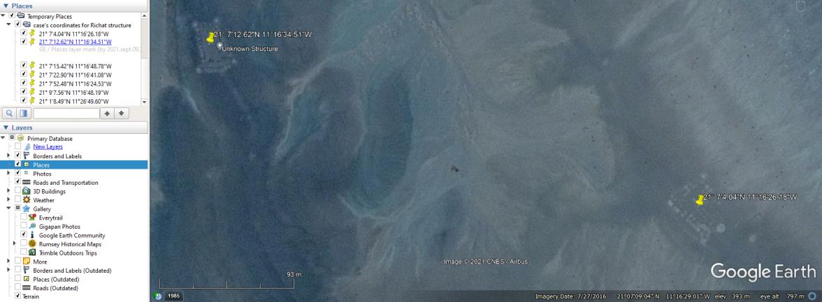 And the content copied from it's info-balloon: (reviews link inactive so far...(?)) Always worth to check spottings also on other online maps, which may provide other (better) imagery for sites, especially around the Sahara. (e.g.: >>21° 7'12.62"N 11°16'34.51"W<< on ZoomEarth) Your penultimate coordinates are sign a site that also I have placemarked some two years ago and identified as a fort. - Easily I can be wrong...! 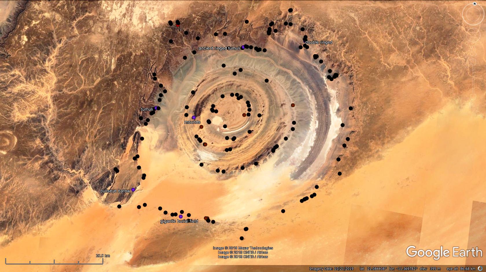 In the same thread you can find a pretty cool info-chart about chronology of climate and structure-types. If you go through that forum thread, you can get further knowledge by our "official" Sahara experts; chriss and tafrawti As my opinion Richat structure has nothing to do with Atlantis, still one of the most misterious corners of the Earth! Have a useful browsing, also keep up posting! ( : All the best! G |
|
Junior Member
September 2021 - Mar 24, 2022 5:08:57 GMT
|
Post by case on Sept 9, 2021 16:22:49 GMT
Yes, added recently. Note the structure at 21° 7'15.42"N 11°16'48.78"W . I have Nick Named it a "Pie Fort". I have found its design to be located through out the region. 18°48'23.70"N 11°39'0.69"W 20°12'13.35"N 13°22'45.83"W 20°12'50.49"N 13°22'36.52"W 22° 6'24.09"N 12° 4'42.66"W 22° 6'34.57"N 12° 4'38.28"W 21°35'8.80"N 11°17'25.88"W Common design represents a unified culture.
The very fact these structures are "Buried" in the second ring, in dried out mud means these structures come from a time when water was plentiful in the region. And Science now tell us that was 5000bc. There are enough structures now identified to show these structures follow the radius of the second ring and are not random. They, majority, are also substantial in size. 70 -300 ft in dimensions. "They" are direct evidence of a lost buried culture. They are indirect evidence of Atlantis's Ringed City. The "Pie Fort" design found in the second ring and the surrounding area shows this buried culture was involved in a larger area, than just the second ring. 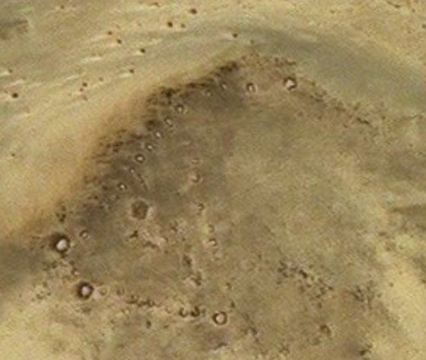 |
|
Master Cartographer
April 2015 - Jul 26, 2024 22:31:24 GMT
|
Post by syzygy on Sept 10, 2021 11:16:14 GMT
I believe these "pie-chart" forts are older than the French colonial era, but much more younger than 7000 years as you suspect. If you check the one at >>18°48'23.70"N 11°39'0.69"W<< on ZoomEarth you can see it is built up of the same structural elements as the more new-looking one next to it: walls, bastions and the smaller, inner structures which were dwelling places of men and livestock. All these are obvious signs of military defence since the first arrow was fired and the first spear was thrown.  Somehow I am pretty sure these are have to do something with the Islam spread. As I have checked history of Mauritania, the most reliable period of time is the Char-Bouba War (1644 - 1674) when these forts could be erected. ...(?)... Here I attach a KMZ folder with placemarks for each of your coordinates, which makes geographical distribution much easier to study. cases coordinates.kmz (1 KB) Please follow this method by your future posts, that would make disquisition much efficient around here! Thanks! G ... (If you'd need help with posts or KMZ files, check out our Help-section! For instant wisdom I advise you to start with this thread.) |
|
Junior Member
September 2021 - Mar 24, 2022 5:08:57 GMT
|
Post by case on Sept 10, 2021 14:45:13 GMT
Then you are saying the Pie Fort buried in the second ring was buried in 1644-1674 time period? Then that would mean all the other structures were buried at the same time? That would have been a pretty large flood to do all that. Something that large would have surly been in the history books. You must forgive my ignorance concerning this BBS board, its been a very long time since I used this relic lol. I do have a security issues with downloading files. KZM, cloud, etc. There is no history before 11th 12th century concerning Mauritania.. And that is mainly the trade routs of gold and salt. There are no mentions of any flooding in this area to link the buried structures to. And using that mindset, the buried structures, by definition, must come from before the history, or, Pre-historic. That is, if you can not supply research or a historical event to explain the buried structures.
|
|
Master Cartographer
April 2015 - Jul 26, 2024 22:31:24 GMT
|
Post by syzygy on Sept 10, 2021 22:16:18 GMT
No. I don't presume any flood event, on the other hand all this only simple guessing by me. ... a site that also I have placemarked some two years ago and identified as a fort. - Easily I can be wrong...! Guy at therichatstructure.com for example describes these as ancient animal pens. --- Also just now have found a blog post of another "unbeliever" at theness.com followed by a discussion on topic. |
|
Junior Member
September 2021 - Mar 24, 2022 5:08:57 GMT
|
Post by case on Sept 11, 2021 2:11:39 GMT
No. I don't presume any flood event, on the other hand all this only simple guessing by me. ... a site that also I have placemarked some two years ago and identified as a fort. - Easily I can be wrong...! Guy at therichatstructure.com for example describes these as ancient animal pens. --- Also just now have found a blog post of another "unbeliever" at theness.com followed by a discussion on topic. I've been researching this subject for just about 3 years, and I can tell you from experience there is a brick wall concerning the Richat, and Mauritania. I call this wall "The Royal Gate Keeping Box Makers". They have created a narrative that Plato was just fiction and enforce that opinion. They make excuse after excuse and refuse to deal with the evidence on the ground. Mauritania entered into a contract with UNESCO and wouldn't you know there tents (Suspected) are everywhere. And where ever there tents show up, things are moved, added, and removed. Check the time stamps on the images and you can see what they are doing. Do the research on UNESCO and you will find big time corruption within their ranks. Someone a year or so ago went to the Richat and wanted to use ground penetrating radar, he was disallowed to use it. Forbidden. The corruption is real. I don't believe or disbelieve this being the Ringed City, but what i do believe is there is a lost society here, and the gate keepers want to keep it, lost. |
|
Master Cartographer
April 2015 - Jul 26, 2024 22:31:24 GMT
|
Post by syzygy on Sept 11, 2021 9:54:53 GMT
Well, yep... If some is real then corruption is. It seems cultures come and go through the mist of eons and we stay at here with the same questions. Your "pie forts" from Mauritania are my "rondelloids" from Mali and we cannot get closer. "Unfortunately there is more chance to visit Mars than visit this area right now. " - was told me by two, independent Africa explorers, but it ain't over that belates... !
Many discoveries awaits still and ever for the curious.
Stay tuned... See you!
G
|
|
Junior Member
September 2021 - Mar 24, 2022 5:08:57 GMT
|
Post by case on Sept 11, 2021 18:14:42 GMT
Well, yep... If some is real then corruption is. It seems cultures come and go through the mist of eons and we stay at here with the same questions. Your "pie forts" from Mauritania are my "rondelloids" from Mali and we cannot get closer. "Unfortunately there is more chance to visit Mars than visit this area right now. " - was told me by two, independent Africa explorers, but it ain't over that belates... !
Many discoveries awaits still and ever for the curious.
Stay tuned... See you!
G
Since one of these "Rondelloids" is buried in the Richat, possibly another one, it then sets the time to when water was available in the region. These buried structures in the Richat represent a lost civilization of that time period. The fact that these designs are found elsewhere indicates that lost civilization was much larger than just the "Eye". The "Pie Fort" "Rondelloid" design, is its hallmark. |
|
Junior Member
September 2021 - Mar 24, 2022 5:08:57 GMT
|
Post by case on Sept 11, 2021 18:25:51 GMT
Well, yep... If some is real then corruption is. It seems cultures come and go through the mist of eons and we stay at here with the same questions. Your "pie forts" from Mauritania are my "rondelloids" from Mali and we cannot get closer. "Unfortunately there is more chance to visit Mars than visit this area right now. " - was told me by two, independent Africa explorers, but it ain't over that belates... !
Many discoveries awaits still and ever for the curious.
Stay tuned... See you!
G
The corruption is real.
UNESCO is corrupt in its inception. Its "Education" arm mis directs any efforts to get to the truth.
Wherever UNESCO is operating, look for corruption.
Another organization that is fighting this disclosure of the lost civilization are what I nick name "The Royal order of the Sublime Gate Keeping Box Makers'. Because? Because its the only reason they exist, it is, their genesis...
|
|
Master Cartographer
April 2015 - Jul 26, 2024 22:31:24 GMT
|
Post by syzygy on Sept 11, 2021 18:41:07 GMT
... one of these "Rondelloids" is buried in the Richat, possibly another one,... Hey man! That would be a real breakthrough in that topic! - What are the coordinates?  Would you please share them? |
|
Junior Member
September 2021 - Mar 24, 2022 5:08:57 GMT
|
Post by case on Sept 11, 2021 19:34:42 GMT
21° 7'15.42"N 11°16'48.78"W  This is the possible second "Pie Fort"/ "Rondelroid". 21° 7'26.02"N 11°16'50.08"W 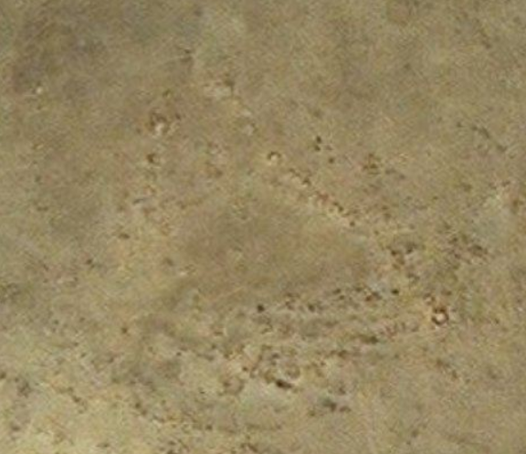 There are others in the area that may have been repurposed throughout the years... Abandon, rediscovered, reused etc. The ones in the Ring, are untouched since the time of burial.. |
|
Junior Member
September 2021 - Mar 24, 2022 5:08:57 GMT
|
Post by case on Sept 11, 2021 21:34:24 GMT
List of "Pie Forts" found so far in Mauritania.
To be continued in following post.
Buried in Second Ring of the Richat Structure.
21° 7'15.42"N 11°16'48.78"W 18°48'23.70"N 11°39'0.69"W
20°12'13.35"N 13°22'45.83"W and 20°12'50.49"N 13°22'36.52"W
21°24'58.82"N 11°13'43.33"W
22° 6'34.57"N 12° 4'38.28"W And
22° 6'24.09"N 12° 4'42.66"W
21°35'8.80"N 11°17'25.88"W Modified.
|
|
Master Cartographer
April 2015 - Jul 26, 2024 22:31:24 GMT
|
Post by syzygy on Sept 12, 2021 22:00:12 GMT
Nope... Some totally different... ) : Frankly, I am very sad to say that these are neither similar in measure, nor in structure to those I have spotted in Northern Mali and South Algeria. Other kind of stuff, built by other folks, presumably even in an other era. Sorry if my english skills have made trick on you - "Your pie forts are my rondelles" phrase is only was meant to be a comparsion, an analogue for the enthusiasm we share for our different kinds of favorite AASSs* (Ancient African Stone Structures - FYI)... ( : I checked all your coordinates one by one, right that time as you've posted, so when you wrote "... one of these "Rondelloids" is buried in the Richat, possibly another one... ", I thought you had further locations that I have not seen already. Thanks for selection anyway! Here one more writing on topic I have found: archaeotravel.eu/sunk-island-in-the-sahara-desert/I bookmark this thread to see or / and continue if any news come up. ... P.S.: Thanks saving storage on our self sponsored forum by minimizing attachment size both by using inserted images and avoiding duplicates! ( ; |
|
Newbie
June 2023 - Jun 17, 2023 14:23:54 GMT
|
Post by stig on Jun 17, 2023 14:23:54 GMT
Hello ALL ! I've been to the Richat structure twice now. All those items are french military fortifications from about 1870. The image with about 100 dots also includes burial tumuli and could be older.
They look like large stones but they are just rings of rocks created for soldiers to lie down in.
That being said, I can show you some stuff there that is hundreds of thousands of years old. I'll try to return here if anyone responds, but I'm davidstighansen in YT, gmail or FB if you want to ask me anything.
Stig
|
|

