March 2015 - May 1, 2023 4:20:37 GMT
|
Post by diane9247 on Jun 30, 2021 6:50:23 GMT
Near Lake Shastina, California. The county forbids "large-scale" marijuana farms, so small lots have been bought in what was intended to be a residential development. Put up a shack, plant an acre or two of marijuana, and you're in business. Local authorities raid them, attempt to close them down, but they are failing to control the situation. The operation is owned by a Mexican drug cartel. The farms are managed by Hmong and Chinese immigrant families, but guarded (with copious firepower) by Hmong men. They aren't afraid of anything and don't want you passing through as a tourist. The area marked is just a small portion of the illegal marijuana trade's territory in N. California and S. Oregon. Some farms are legal, the ones in the area I marked are not (unlicensed, therefore untaxed). The Lake Shastina area was in the news tonight because an armed Hmong pulled his gun on a police officer who was ordering residents to evacuate. There is a fast-growing fire on the hillside called the Lava Fire, and the man with the gun was trying to re-enter the marijuana growing area. Perhaps to rescue his equipment, weapons, or guard his crop. Who knows. This is why it's fun to go to GE to find places you see in the news. There's usually something interesting there. It isn't until you zoom in close that you see how many discrete little gardens there are. Source Marijuana Legality Map - all 50 states Marijuana farms.kmz (1.71 KB) |
|
Master Cartographer
April 2015 - Nov 21, 2024 8:06:11 GMT
|
Post by syzygy on Jun 30, 2021 7:31:38 GMT
Amazing! What a change in a few years...! And not only in state law. I have checked SV on webGE on my phone, and well, I could not see any SV dates displayed, but there was nothing except natural shrublands as SV Cab was been there.* Interesting coincidence(?), your placemark set is only a few miles NE of Weed...! ( : Many thanks for You to keep us informed about most interesting recent happenings around! diane9247 - global moderator, master news hawk ( : *Edit: Checking GE TimeSlider we see that nothing really happened between 1985-2014. Then "pot-age" has started... For comparsion check this screeine pair of 2014 and 2016 imageries on a random location: [slide captionposition="1" wrapperstyle="padding:10px 0;border-top:2px solid #eee;border-bottom:2px solid #eee;"]https://res.cloudinary.com/syzygy/image/upload/v1625045987/NC.pot.2014_xknatx.jpg 2014 res.cloudinary.com/syzygy/image/upload/v1625045987/NC.pot.2016_nyyglr.jpg2016[/slide] |
|
March 2015 - May 1, 2023 4:20:37 GMT
|
Post by diane9247 on Jul 22, 2021 10:02:50 GMT
Since I posted this there has been a large fire that destroyed most of the area I have shown. The Lava Fire currently covers over 26,000 acres and is 77% contained. SourceMy son, who works for the US Forest Service, told me something that was both weird and funny about fires in marijuana territory. When the farms catch fire, the crews are told to disengage. It wouldn't do to have them "fighting high!" So, if you own a pot farm and it's burning, you'll have to deal with it yourself.  |
|
Master Cartographer
April 2015 - Nov 21, 2024 8:06:11 GMT
|
Post by syzygy on Jul 22, 2021 14:57:00 GMT
Seems 2021 will not be the Year of Ganja... fires in N.California, volcano eruption in St Vincent and the Grenadines, huge police catches in my town, ... oh, oh, ... |
|
March 2015 - May 1, 2023 4:20:37 GMT
|
Post by diane9247 on Nov 21, 2021 9:55:54 GMT
I have an interesting update to this story. Southern Oregon has become a big player in the illegal weed trade. It has exploded over the past 2-3 years and is costing police departments in the state more money than they have. There are illegal small farms in Oregon, too, but most of the news has come from the discovery of enormous processing warehouses closer to towns and major highways. Oregon State Police discovered a massive 500,000 pounds in White City, Oregon, worth approximately $500 million in street value. Last month there was a discovery in a warehouse just south of my city (Klamath Falls). There was an estimated $120 million in that bust and at the time, it was the largest amount ever discovered in one place in Oregon. SourceFound in a potato shed south of Klamath Falls in October. The fire department had been called because someone saw smoke in the area (seriously 😂 ). A Sheriff's deputy happened to look into an open warehouse door and saw this... 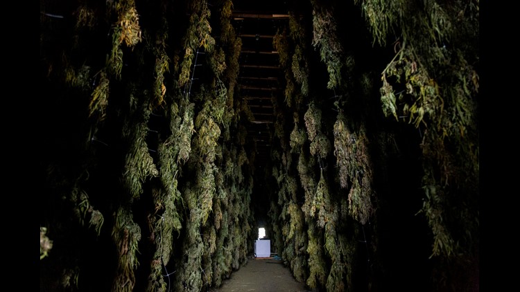 Source Source
Both of these locations are part of a Mexican drug cartel. Both towns are on the route taken by shippers going north and east, possibly into Canada. Illegal marijuana still has a large percentage of the market, because it's a lot cheaper than the legal product. It's not taxed or regulated by any government, so that brings the cost way down. On the other hand, the consumer never knows what additives are in the marijuana bought illegally. It could be anything from filler of another kind of plant to the deadly opioid fentanyl. File shows both locations. The White City one is an educated guess based on a partial address. Big marijuana processing plants.kmz (1.06 KB) |
|
March 2015 - May 1, 2023 4:20:37 GMT
|
Post by diane9247 on Nov 21, 2021 10:33:22 GMT
Interesting coincidence(?), your placemark set is only a few miles NE of Weed...! ( : Ah yes, a local curiosity! The town of Weed was there long before that word was used for marijuana. It's an old lumber mill town and the junction of the two major highways in Oregon. It's named after the owner of the first lumber mill, Abner Weed. It became a source of jokes and many new kinds of souvenirs during the "Age of Aquarius" and has been ever since.😤 About 1/3 of the town was destroyed in a fast-moving fire several years ago. |
|
Newbie
December 2022 - Jan 5, 2023 14:17:33 GMT
|
Post by ariannakaufman on Jan 2, 2023 22:56:23 GMT
Illegal marijuana cultivation can lead to harmful consequences. Local authorities should regulate this activity to prevent unlawful actions by entrepreneurs. When I order cannabis flowers to make CBD extract, I check all the necessary documents. Buying from illegal representatives makes you a criminal, too. I order cannabis at herbheaven.co. I know for a fact that it is a quality product, and all operations are transparent. I don't practice buying cannabis from resellers, because it can lead to many problems. My safety is important to me. So always check the place you order such products from. |
|
Newbie
December 2022 - Feb 4, 2024 19:13:31 GMT
|
Post by clarkmelton on Apr 12, 2023 23:46:34 GMT
Illegal marijuana farms pose a risk to consumers as the products they produce are not subject to any regulatory oversight. This means that the quality and safety of the products cannot be guaranteed, and consumers may be exposed to harmful substances or low-quality products. Illegal marijuana farms pose a risk to consumers as the products they produce are not subject to any regulatory oversight. This means that the quality and safety of the products cannot be guaranteed, and consumers may be exposed to harmful substances or low-quality products. That's why it's important to choose reputable brands that use hemp-derived CBD oils that have been rigorously tested and verified to ensure their purity and quality. These products are manufactured in compliance with all applicable regulations and guidelines, ensuring that consumers can have confidence in the safety and efficacy of the products they purchase. |
|
Newbie
May 2023 - Mar 14, 2024 10:10:30 GMT
|
Post by daudalazarus on Mar 14, 2024 10:14:02 GMT
As discussions around cannabis legalization continue to evolve, it's essential to engage in constructive dialogue and collaborative efforts to navigate these complexities and foster positive outcomes for all stakeholders involved.
|
|
Newbie
March 2024 - Mar 18, 2024 9:58:48 GMT
|
Post by alexussawyer on Mar 14, 2024 10:27:18 GMT
The situation you've described sheds light on the intricate challenges surrounding marijuana cultivation, particularly in areas where regulations may be lax or enforcement inconsistent. The coexistence of legal and illegal operations underscores the need for comprehensive regulatory frameworks to ensure safety, legality, and accountability within the industry. It's crucial to address issues such as unlicensed cultivation, taxation, and community safety while also recognizing the potential benefits of medical cannabis for patients in need. |
|


