Newbie
October 2020 - Dec 30, 2020 20:33:13 GMT
“ We may be slow, but we get the job done. „
|
Post by sealtripper on Oct 9, 2020 20:54:11 GMT
|
|
Newbie
October 2020 - Dec 30, 2020 20:33:13 GMT
“ We may be slow, but we get the job done. „
|
Post by sealtripper on Oct 9, 2020 21:26:16 GMT
|
|
Master Guide Admin
March 2015 - Apr 20, 2024 8:06:34 GMT
|
Post by nostranger on Oct 10, 2020 2:28:01 GMT
Gooday sealtripper, This type of searching for lost aircraft has been done before,, Mainly instigated when Steve Fossett went missing in September 2007. Imagery analysis can be a frustrating task at the best of times , let alone when using old or low resolution imagery. Of course one has to make sure that the imagery is post the event that is being investigated, them, it is hoped that the highest resolution ,imagery is available. It appears from your coordinates that the latest imagery on GE for that location is 8:00 AM September 15 2010. In most cases GE is dated and very rarely up to date or post an event,, resolution is pot luck but usually not high enough to clearly identify specific objects. In past searches, the latest imagery has been acquired from the Companies that capture satellite imagery and then overlaid on GE so that precise coordinates can be determined. When and if the imagery capture companies do have the type of captures that suit, they are usually more than happy to contribute when it's explained for what the imagery is going to be used for, the advertising spin off is quite good for them. A good way to analyze imagery is to find some of a known object in similar locations or terrain and compare them to the object that you are searching. If you are not already aware of it, there are some examples of detailed searches on forums.internetsar.org/I hope this helps you in your quest. Cheers. |
|
Newbie
October 2020 - Dec 30, 2020 20:33:13 GMT
“ We may be slow, but we get the job done. „
|
Post by sealtripper on Oct 10, 2020 11:38:58 GMT
Thanks. The plane we are looking for has been missing since 1950, and this location fits nicely into the flight’s known last position. Can the coordinates be in error, or did the Satellite algorithms just draw something plane shaped? Aerial photos over the last 30 years show something there vaguely, but are poor resolution. Boots on the ground found nothing. Plane is findable, but likely scattered instead of whole like the image. Few people are really looking for it anymore as many fraudulent witnesses at the time spread the searching out over half a million square miles. We believe the plane still remains in the original 5000 mile “box” it went missing in which can be very remote forested area.
you have your own plane to find in Australia- we looked a while once for that single engine missing many years ago in the national park south of Sydney. That is a tough one, as it will likely be wingless and stuck in the canopy of the forest there. Maybe a 10x20 speck of wreckage.
we have a shaky list of eight to ten findable aircraft on land from 1950 through 2015. Wish more people and governments were interested in finding them.
|
|
Master Gamer
April 2018 - Apr 24, 2024 20:09:33 GMT
|
Post by willi1 on Oct 10, 2020 12:08:50 GMT
Welcome to the forum, sealtripper !
Unfortunately, with Zoom Earth nothing can be seen there either.
|
|
Master Guide Admin
March 2015 - Apr 20, 2024 8:06:34 GMT
|
Post by nostranger on Oct 10, 2020 15:08:12 GMT
Interesting scenarios present themselves doing this type of search.
Whilst looking for one specific plane, or wreckage, other wreckage of planes that have either been forgotten or not reported lost in the first instance crop up.
WWII planes are sometimes found when looking for current wrecks.
Drug runners are also found that have not been reported for obvious reasons.
That Canadian air space has gobbled up quite a few planes that have not been found.
Guyana is another area that hides many a plane wreck that have still not been found.
Good luck with your quest, I'm sure you will find many a mystery along the way.
|
|
Full Member
May 2020 - Jun 14, 2023 19:51:52 GMT
|
Post by KitsuneFox on Oct 12, 2020 1:41:09 GMT
Douglas C-54D by the looks of it, registration number 42-72469. Believed to be somewhere in the general area of Snag Canada ... however no evidence has ever been found to suggest an aircraft crashed in that area. Edit: if anyone is looking for the location noted above, it's to the east of Quill Peak, ane west of Canada Route 1 ( Alaska Highway ) . goo.gl/maps/vpyHDbmsigqkSpcL9 |
|
Newbie
October 2020 - Dec 30, 2020 20:33:13 GMT
“ We may be slow, but we get the job done. „
|
Post by sealtripper on Oct 22, 2020 22:46:51 GMT
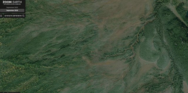
Anyone have any musings on the images we presented. Sure thought this object was our missing plane even if unlikely to have been so pristine. Still haven’t fully come to accept that it isn’t real. Can GE software draw something so detailed without a realistic object to go with it, or is this just shading and light playing tricks. Please take a minute to pull up each of the eight or nine images and shoot me some feedback, otherwise my next posting will be of the many cars on blocks in my neighborhood. No seriously, we must have the highest density of cars on blocks and outside washer machines in the world.  |
|
Newbie
October 2020 - Dec 30, 2020 20:33:13 GMT
“ We may be slow, but we get the job done. „
|
Post by sealtripper on Oct 22, 2020 22:52:00 GMT
Douglas C-54D by the looks of it, registration number 42-72469. Believed to be somewhere in the general area of Snag Canada ... however no evidence has ever been found to suggest an aircraft crashed in that area. Edit: if anyone is looking for the location noted above, it's to the east of Quill Peak, ane west of Canada Route 1 ( Alaska Highway ) . goo.gl/maps/vpyHDbmsigqkSpcL9Your link is off by about eight miles. Object is on NW side of Swede Johnson Peak, about six mile from highway. It’s a Lon/Lat versus GPS thing. |
|
Newbie
October 2020 - Dec 30, 2020 20:33:13 GMT
“ We may be slow, but we get the job done. „
|
Post by sealtripper on Oct 22, 2020 22:58:25 GMT
Welcome to the forum, sealtripper !
Unfortunately, with Zoom Earth nothing can be seen there either.
|
|
Newbie
October 2020 - Dec 30, 2020 20:33:13 GMT
“ We may be slow, but we get the job done. „
|
Post by sealtripper on Oct 22, 2020 23:00:32 GMT
  Image is there, just left of center. Its just not clear what it is. Will try to post the Zoom shot. |
|
Junior Member
June 2021 - Oct 18, 2022 21:20:39 GMT
|
Post by tafrawti on Jun 16, 2021 15:13:25 GMT
we came upon the attached images which we thought exactly matched our missing aircraft. In reality, physically being at the spot indicated by Lon/Lat and GPS and there is no object or anything similar at that spot. Is this a Rendering error, optical illusion, algorithm stitching together a pattern, etc. This image so perfectly represented what we were looking for that if not real, than GE is of little use. The image shows across several different products, and over time. Unsure what to make of it. Would love to hear from someone with experience with this, or software experts to explain how this image was created. I Yep - I'd agree - I think you've found the exact aircraft type from the pictures you've posted. The wingangles, enpennage shape, all match. Not sure abotu dimensions, but what is visible in recent photos is a hole in the trees-shape, not the airframe itself, so shadow and angles can make it look much larger than the airframe dimensions. We also need to take into account photo angles and compunding errors, so trusting measurments alone to confirm it on the imagery is likely to be rather innacurate.
In addition, I predict no rendering error, optical illusion, algorithm stitching error etc that (with much significance added here>>>) materially affects the image you are seeing. I'm saying yes, it probably/maybe/kinda is the plane you see. Or a very similar one. What I do think is that you are misinterpreting the coordinates GE and possibly ZE or other products have given you, leading to a hitherto fruitless search.
If you were born in the age of dead-reckoning navigation, you'd realise that nothing is perfect and there's always a fudge factor. In this particular case, the fudge factor could be a large one and in terrain such as this area that's where big practical problems can occur. This is why old folks just use handwave estimations and trust nothing until they are sure of things. We've kinda lost that scepticism in the modern age of cellphone GPS and the internet and expect absolute accuracy in all things that whirr, glow and flash lights. Especially if they work fine for us in most everyday uses. But this is not everyday use, this is a once in a generation or once in a lifetime special use. We have several issues at play here that affect the coordinates and how the imagery is presented alongside them. Off the top of my head, these include:- The ellipsiod shape of the planet vs. the actual shape of the planet at both the satellite position and the crash site. In general, this means "how spherical, (or actually not very) we *think* the planet is. Distortion in the optical system of the satellite leading the image to be somewhat non-flat. All lenses exhibit some distortion. Wikipedia Distortion article- related: the associated compromise of "correction" if any, added by the image processors at the image product stage. (aka "distortion correction" or "lens correction") The eventual compromise of stitching performed in GE software, or other websites, with possible stretching of images to fit. This is akin to the map projection problem, but on a smaller scale (as each photo image likely covers an area smaller than a printed flat map as long as a long enough focal length lens is used on the satellite) The accuracy and resolution of terrain data mesh utilised by GE (and the fact that flat-map sites like ZE, Bing, Yandex etc may not even utilise a mesh) vs the reality of terrain on the ground. There is a clue in the images that make me predict your coordinates are actually off. Possibly well off. Two clues actually. One is the angle of the trees. If the satellite were dicectly overhead, we would not see tree trunks, because they are vertical. We'd just maybe see a pinprick in the centre (the tip of the trunk at the top of the tree, with a broadly even-distibuted set of branches. We'd be seeing a perfect "top-down" tree from directly above. But we aren't. We see lots of tree trunks and quite a lot of distortion. This is clear to see in the trees to the east of the plane, near the globular features that looks like blobs of paisley swirls (right side of image). Here the tree trunk are visible down to ground level, likely because we are looking across a creek into rising terrain and we see the base of the trees as well as the tops. The second thing that tells me to beware is that it's 61degrees N. Most, but not all imaging satellite operate nearer the equator. Not neccessarily because they are located permanently (geostationary) above the equator, but because this gives them a good "sun angle" for illuminating general views. in simple terms, this gives nice sunny photos akin to the old photgraphy tip of "stand with the sun over your shoulder then face the subject". In a future post, I'll descibe how the positioning errors add up in a easy-to relate manner. Run out of time for now, sorry. Gotta go. After that, it's going to be down to a search pattern but with realistic appreciation of the datum given all the cumulative errors. You're gonna need a team of experienced outdoorsmen (like lumberjacks) and a lot of sweat. |
|
Junior Member
June 2021 - Oct 18, 2022 21:20:39 GMT
|
Post by tafrawti on Oct 17, 2022 17:47:23 GMT
Holy thread-resurrection Batman! etc etc This old thread crossed my mind while I watched a Itchy Boots motorcycling video on Youtube today. I'm on very limited resources here - a 7 inch tablet - I'm on the road - but I think I see a plane shape on Google Maps at the following location - imagery date claims to be* 2022 www.google.com/maps/@61.7320109,-139.4995723,124m/data=!3m1!1e3?hl=en REQUEST - could someone check this out on Gogle Earth and comment? I believe I see an intact wing, fuselage, empennage and TWO visible engines (not four, though the rest could have detached in the crash/landing roll/slide. Also with a hint of something like the ridge above each engine nacelle as per the DC54 style. Maybe I'm seeing things though - hence me asking for someone to take a proper look. While I think of it - for any future on-the-ground searchers, it appears to be lying on the southern/south-south-east - facing downslope of a small ridge that runs WSW-ENE, guessed solely from the low angle sun and lighting direction. NOTE: due to datum and other errors, the lat/long could be well off in GE vs GM * I suspect some imagery dates are far from accurate on Google Maps |
|
Junior Member
June 2021 - Oct 18, 2022 21:20:39 GMT
|
Post by tafrawti on Oct 17, 2022 18:59:54 GMT
From GM, the coords - this may help people locate it in GE
61.731963,-139.499659
61°43'55.1"N 139°29'58.8"W
61.731963, -139.499659
I'm on the VPN right now to see if I can grab some old "general area" satmap imagery I worked on a few couple of months ago, but never posted to the thread
edit - just noticed the coords don't match the OP, though that copuld be stitching/coords/datum issues.
So, for now, if you want to see what I just saw, use my coords in this post, first in Google Maps, then visually overlay other sources, like Bing Maps (nothing concluding to be seen on Bing (summer imagery) more just shadows that the surrounding area, no plane shape.
found my area orientation annotated images, posting in a few mins
|
|
Junior Member
June 2021 - Oct 18, 2022 21:20:39 GMT
|
Post by tafrawti on Oct 17, 2022 19:22:16 GMT
okay, to help cross-reference different satelite imagery sources we need annotated maps of landmarks - especially at such latitudes as 60N Coordinates my not be exact between different sources or even between different image sets on the same site ( for example moving the historical image slider on Google Earth can show the sat images to move sideways or up/down over the years) Here are an image or two I have recently annotated with visual features to help guide people in to to my crash site (as opposed to the OPs) OPs imagery seems to show the wreck viewed from the port wingtip - suggesting the photos were taken from the east - if it's the same wreck I'm looking at?? Wheras "my" wreck seems to lie largely facing south or SSE - could this be two different wrecks we are looking at ? << help and opinions needed please. << OP comment ? Anyways, "my" wreck site is annotated in the following map images - THESE IMAGES BASED ON THE ZOOM EARTH IMAGE "NOTHING SEEN" VIEW POSTED EARLY IN THE THREAD BY WILLI1 Overview - including river bends and lakes - imgur.com/a/0yUHfQz < help me someone - can't get the image links to work properly? They are public on Imgur CLOSER ZOOM referenced sharp triangular lake imgur.com/a/u0QVk4rI'm heading into civilisation soon so will grab GE and GM locations and screenshots and post here if I remember GE coords current at mid-October 2022 Winter view with quite a clear plane shape at same place as sealtripper shows mid-thread 61.731963,-139.499659 61°43'55.1"N 139°29'58.8"W 61.731963, -139.499659 meantime - paging sealtripper - any updates? |
|
Master Gamer
April 2018 - Apr 24, 2024 20:09:33 GMT
|
Post by willi1 on Oct 17, 2022 19:36:44 GMT
My Opinion: For me an example of pareidolia, there shouldn't be any better pictures. At around 20 meters long, it is also much too short for a passenger plane.  |
|
Junior Member
June 2021 - Oct 18, 2022 21:20:39 GMT
|
Post by tafrawti on Oct 17, 2022 19:42:53 GMT
My Opinion: For me an example of pareidolia, there shouldn't be any better pictures. At around 20 meters long, it is also much too short for a passenger plane. But the wingspan is much closer to C54 dimensions - wingtip to wingtip. Depending of view angle of the satellite (not all sat-or-airliner photos are taken from directly overhead especially at these latitudes) the wreck could be considerably nose-down. As I note a couple of posts earlier, the shading and low sun angle suggests it is lying nose-down on the more sunlit side of a ridge. Much sat imagery of the area shows it as very "flat" with poor definition of slopes/hills, but the low sun angle of the winter shot clearly shows deep shadow to the NNW of the site just over the ridgeline. As I noted earlier I also only see two engines on this image - so it may not be a C54 wreck at all, possibly another airframe. OMG I suck at forum quoting and editing - sorry guys |
|