Master Guide
March 2015 - Jan 20, 2022 4:27:51 GMT
|
Post by Hill on Apr 23, 2015 23:42:32 GMT
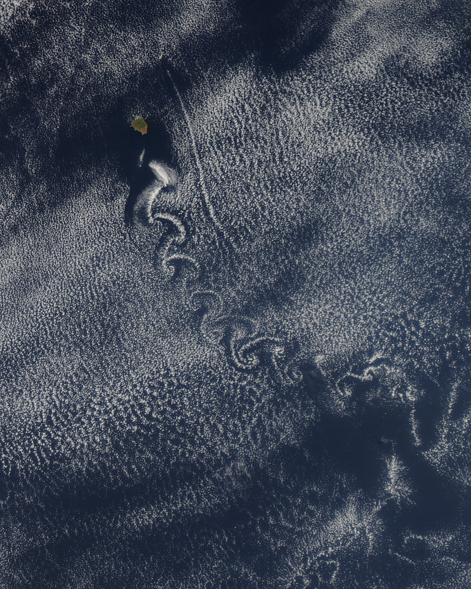
In the wake of the Crozet Islands in the southern Indian Ocean, disrupted air masses have formed patterns in the clouds. This pattern is similar to that seen when eddies form in water running over a pebble on an otherwise smooth surface for much the same reason. In this case, air that had been flowing smoothly over the ocean’s surface is disrupted by the islands, and the clouds, controlled by air currents, have assumed the shape of the disrupted air. Two distinct patterns have formed in the clouds. In the west, left, the clouds have taken a “V”-shaped pattern called ship-wave-shaped wave clouds. To the east, center and right, cloud vortices swirl delicately behind the last of the islands. Source
 Credit: Jacques Descloitres, MODIS Rapid Response Team, NASA/GSFC Credit: Jacques Descloitres, MODIS Rapid Response Team, NASA/GSFC |
|
Master Guide
March 2015 - Jan 20, 2022 4:27:51 GMT
|
Post by Hill on May 18, 2015 23:07:11 GMT
Also from NASA's Visible Earth, which is really good for capturing ephemeral events that Google earth does not want, is this picture of wave clouds formed by Amsterdam Island in the Indian Ocean. Image Caption: " The cloud patterns seen in this image resemble ship waves or “Kelvin ship waves”, which are the V-shaped wakes left by moving objects, such as ships or even ducks. The pattern is not coincidental; wind behaves like a fluid, so when it encounters an obstacle, it must move around it, leaving behind a wake or a visible wave pattern. As the air crested a wave, it cooled and clouds formed. Then, as the air sank into the trough, the air warmed, and clouds did not form. This pattern repeated itself, with clouds appearing at the peak of every wave. In this case, the obstacle is an island. As the wind flows past the island, it is swept around and over it leaving a wake similar to that of a ship-- hence the name “ship-wave-shaped” clouds. Clouds are made up of many small droplets of water or ice crystals, formed around what is called a condensation nucleus: a small particle of dust, ash, or smoke. They reflect all visible wavelengths of sunlight, which often makes them appear white. However, clouds sometimes appear gray or even black, as they do in some portions of this image. This phenomenon is caused by the process of accumulation, where droplets within the cloud merge with others, forming larger droplets. The space between droplets then becomes larger, allowing more light to be absorbed within the cloud, thus making portions of it appear to be darker to the naked eye. Amsterdam Island is located in the Southern Indian Ocean, between Africa, Australia, and Antarctica." Source page. Image credit: Jeff Schmaltz Download the attachment for a view in Google earth |
|
Master Guide
March 2015 - Jan 20, 2022 4:27:51 GMT
|
Post by Hill on Jun 16, 2015 16:16:06 GMT
This island off the west coast of Mexico shows what Google earth imagery misses. "Theodore von Kármán, a Hungarian-American physicist, was the first to describe the physical processes that create long chains of spiral eddies like the one shown above. Known as von Kármán vortices, the patterns can form nearly anywhere that fluid flow is disturbed by an object. Since the atmosphere behaves like a fluid, the wing of an airplane, a bridge, or even an island can trigger the distinctive phenomenon. On May 22, 2013, the Moderate Resolution Imaging Spectroradiometer (MODIS) on NASA’s Aqua satellite captured this natural-color image of cloud vortices behind Isla Socorro, a volcanic island in the Pacific Ocean. The island, which is located a few hundred kilometers off the west coast of Mexico and the southern tip of Baja California, is part of the Revillagigedo Archipelago." SOURCE
 Credit: NASA image courtesy Jeff Schmaltz, LANCE/EOSDIS MODIS Rapid Response Team at NASA GSFC. Caption by Adam Voiland. Credit: NASA image courtesy Jeff Schmaltz, LANCE/EOSDIS MODIS Rapid Response Team at NASA GSFC. Caption by Adam Voiland. |
|
Master Guide
March 2015 - Jan 20, 2022 4:27:51 GMT
|
Post by Hill on Jun 30, 2015 3:08:43 GMT
"Two unique types of waves ripple through the Indian Ocean in this spectacular true-color Moderate Resolution Imaging Spectroradiometer (MODIS) image, taken by the Terra satellite on November 11, 2003. Credit: Jacques Descloitres, MODIS Rapid Response Team, NASA/GSFC" "An ocean wave is a type of gravity wave, named for the restoring force of gravity that pulls down on the water as the force of buoyancy pushes it back up. The simplest examples of gravity waves are familiar small ripples in a pond or large waves in the ocean. These occur at the water's surface where it meets the less-dense air. "Because the atmosphere becomes less dense with altitude, it too can support gravity waves, but atmospheric gravity waves spread both upward and outward. Just as pond ripples or ocean waves are often created by wind, atmospheric gravity waves are created as wind blows over mountains. And just as surface waves crash into the coastline, gravity waves also break in the atmosphere, creating a high-altitude surf zone and generating air turbulence.
Source |
|
March 2015 - May 1, 2023 4:20:37 GMT
|
Post by diane9247 on Jul 17, 2015 5:55:08 GMT
Superb posts, Hill. It's remarkable how much air disturbance a relatively tiny island can cause. It would be nice if GE would show a few of these, if only as token examples. Your explanations and links are great!
|
|
