Post by syzygy on Jun 5, 2019 12:52:06 GMT
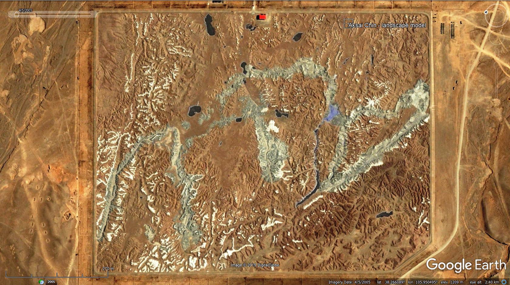
on GE it has only one, lonely GEC layer mark by master KenGrok - it was first posting of his and -in layers- it is still remains unexplained and unidentified:
more: SMH's introduction of KenGrok ### Terrain model's Blog by Ken
...
todays, on wikipedia one can read the followings:
source: en.wikipedia.org/wiki/Aksai_Chin
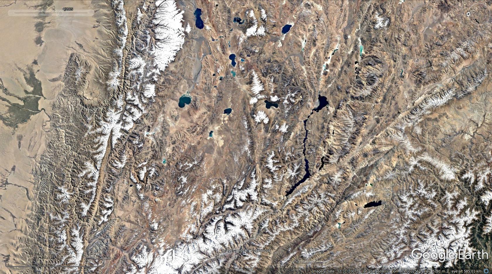
I have made a placemark pair with views set to compare the real and modelled terrains:


clear, it is situated in a military zone also might be part of a tank training ground, but hardly I believe, that tanks have ever had thread on it...
incredible precision of orientation and rates, also level of details are astounding! - it seems, China-BigBrother really is interested in the area.
all the peaks, bends, passes up till the the very last corner can be memorized most easily this way, besides I am not sure whether if its the only usage.
Aksai Chin.kmz (1.02 KB)
(doubleclick on placemarks for views which are suitable for comparsion)
any opinions, news or further infos welcome!
By: KenGrok
Date: 2006-06-29
[My first post ever, please be patient]
On the west side of the village Huangyangtan is what I take to be a military facility of some kind (judging by the masses of olive-colored trucks parked there). And right next to that is a scale-model of a landscape. I haven't tried to identify which region it depicts, but it doesn't seem to be a model of the region where this has been built. The model is mostly mountain ranges, complete with lakes and snow-capped peaks.
Googling Huangyangtan comes up with a number of reports about anti-desertification measures to be taken there (assuming this is the same Huangyangtan as I have found here). There does seem to be a lot of tree-planting around the facility and the model. But not enought to stop sand from blowing into Beijing. The whole area to the west looks like a military exercise area. Maybe if I could read them the giant Chinese letters painted onto some of the hills would tell me more about that area, at least.
In any case, any ideas what the function of this model landscape has?
-- KenGrok
...
todays, on wikipedia one can read the followings:
Aksai Chin is a disputed border area between China and India ... In June 2006, satellite imagery on the Google Earth service revealed a 1:500 scale terrain model of eastern Aksai Chin and adjacent Tibet, built near the town of Huangyangtan, about 35 kilometres (22 mi) southwest of Yinchuan, the capital of the autonomous region of Ningxia in China. A visual side-by-side comparison shows a very detailed duplication of Aksai Chin in the camp. The 900 m × 700 m (3,000 ft × 2,300 ft) model was surrounded by a substantial facility, with rows of red-roofed buildings, scores of olive-colored trucks and a large compound with elevated lookout posts and a large communications tower. Such terrain models are known to be used in military training and simulation, although usually on a much smaller scale.
Local authorities in Ningxia claim that their model of Aksai Chin is part of a tank training ground, built in 1998 or 1999.
Local authorities in Ningxia claim that their model of Aksai Chin is part of a tank training ground, built in 1998 or 1999.
I have made a placemark pair with views set to compare the real and modelled terrains:


clear, it is situated in a military zone also might be part of a tank training ground, but hardly I believe, that tanks have ever had thread on it...
incredible precision of orientation and rates, also level of details are astounding! - it seems, China-BigBrother really is interested in the area.
all the peaks, bends, passes up till the the very last corner can be memorized most easily this way, besides I am not sure whether if its the only usage.
Aksai Chin.kmz (1.02 KB)
(doubleclick on placemarks for views which are suitable for comparsion)
any opinions, news or further infos welcome!
