Senior Member
Explorer
April 2015 - Feb 4, 2022 7:30:41 GMT
|
Post by farceur on Sept 9, 2018 4:15:27 GMT
Am I the only one that find's it hard that a "Tech sleuth" doesn't know the difference between a crashed aircraft and an aircraft in flight.
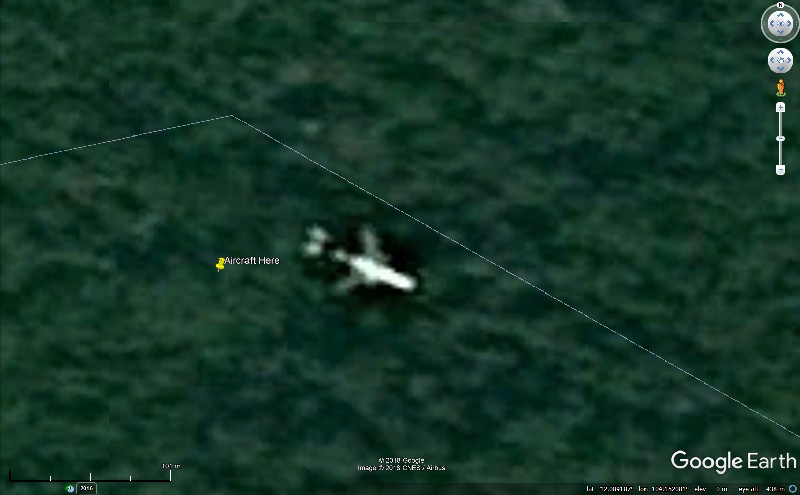
A crashing aircraft on a glide slope will leave a trail of destruction with not much left recognizable. A nose down crash would destroy the aircraft with not much left recognizable. How could a "Tech Expert" get those fundamental facts so wrong? The image could have been taken just before the crash but the crash would have been at night unless the plane was circling for several hours. No. Sorry. Wrong answer. 
To be fair it doesn't look like a typical aircraft in flight but that's how they looked in GE a long time ago. I sure someone can explain that slight anomaly?
|
|
Master Gamer
April 2018 - Nov 24, 2024 20:52:31 GMT
|
Post by willi1 on Sept 9, 2018 15:04:19 GMT
I can not prove if this is actually a relic of MH370 flight of March 2014 or not. Of course I can only serve with my experience on Google Earth. Let us turn to the facts provided by Google Earth. Most important question:When has been the aircraft-picture take up? Hard to say, the time slider itself is not helpful at this place. Normally, the actual date of the recording is displayed at the bottom of the screen, even at high zoom levels. That is not the case here. (Data named 12/31/ xxxx, also 1/1/ xxxx, probably only indicates the year of record.)
The linked article says:
"The Bureau of Aircraft Investigations Archives told The Daily Star they could not rule out Wilson's sighting - which is dated 2018 on Google Earth. "
I think that's not true. The ad in the picture is © 2018, this is not a picture date, but the date of the copy right.
If one examines that on the spot concretely, one comes to other statements. If you use the timer slider from 2014, you will not see any aircraft at the point, not even in 2015. 2016 is the place completely without image data. The setting without timer slider is probably a composition of image data of different recording times. Since the image part with the airplane shows no concrete date probably basic data are used. I think that's what you get displayed with the Layer Spot Image. And that would be the 05 FEB 2012.
See also the pictures here.
Picture with Image Date: 2014 / 2015 / 2016 / without time slider
So unclear, that with the date.
Just leave now the date unnoticed and look at the plane.
Yes, that could be a B777 ER. I put an overlay over it once.
See image
But is it in the woods now or flying over it?
If it is a crashed plane I hardly believe that it would have survived the crash so unscathed.
The impact forces are enormous (maybe 100 G or more with a sudden deceleration of perhaps 300 km/h to 0 km/h), everything is more or less torn.
The situation could only make sense on a belly landing. And that would certainly not have been here.
And yet you see a whole plane and no debris (which would hardly be seen in the poor resolution). And the slope is wooded, you can see no damage to the vegetation. In addition, the impact point would probably be overgrown again within a short time.
The elevation profile says that a valley has to be flown over there. The flight direction clearly shows against a slope with about 30% inclination. That's quite steep, the plane would have had to crash into the slope.
So an overflight?
Let's take a look at the area in Flightradar24. Just in the location is the airway to the airport Phnom Pen Pochentong (PNH), which is about 95 km away.
I have inserted an overlay of an approach. The flight TG584 shown here go to PNH and the track is about 10 km from our plane. (The width of the airways is around 20 km, so it fits). And the direction of flight is completely identical. (See overlay)
If I now summarize the findings, I would say:
It's not MH370. It is an aircraft (perhaps a B777ER) that is approaching the landing in Phnom Pen. The date is uncertain, possible 05/02/2012 (but GE insiders would have to be interviewed).
Use the KMZ file and check it yourself.
But maybe someone has a better explanation?
Attachments:A Plane.kmz (848.44 KB)
|
|


