Newbie
December 2017 - May 5, 2022 8:38:10 GMT
|
Post by brunob on Dec 30, 2017 14:59:01 GMT
I Found a strange and interesting linear structure in the extreme south of Libya. Partially covered by dunes, it is located in the southern part of the area anciently affected by the civilization of Garamantes to which it probably belongs. Any idea? Maybe an ancient commercial route?
ancient route garamantes.kmz (1.32 KB) |
|
Trusted Member
account is disabled
“ Google Maps | Google Sky | Google Mars „
|
Post by ET_Explorer on Dec 31, 2017 4:11:13 GMT
Could be volcanic related.
|
|
Newbie
December 2017 - May 5, 2022 8:38:10 GMT
|
Post by brunob on Dec 31, 2017 14:57:03 GMT
Doesn't it seem too regular pattern to be natural? Each node is strictly distant from the next about 5-6 meters. In the meantime I found other signs nearby. Updated link. |
|
Junior Member
July 2015 - Jul 12, 2018 0:49:14 GMT
|
Post by jamil on Jan 1, 2018 0:46:26 GMT
Hello brunob This is what I found . They are an ancient irrigation system of the Garamantes . They're called Foggaras. When I searched for the ancient capital of the Garamantes called Germa today , I found them too : Foggaras in Germa.kmz (700 B) Here's how they look like : ![]() 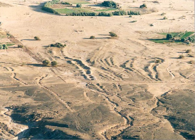 original description (flikr) : Foggara, underground irrigation channels constructed by the ancient Garamantian civilisation, taken from the escarpment above the town of Ubari. The lines on the ground surface are the spoil heaps from the excavation and maintenance of the foggara. Foggara enabled the Garamantes to thrive and pursue agriculture in this hyper arid region from around 500 BC to 500 AD.  |
|
March 2015 - May 1, 2023 4:20:37 GMT
|
Post by diane9247 on Jan 1, 2018 7:10:20 GMT
Nice find, brunob and jamil. Once you get used to where these might be, you start seeing them across an enormous swath of the Middle East and China. In Iran, they're called q anats and in the Uyghur region of China they are karez.Although it's an ancient method, many of these systems are still in use. |
|
Newbie
December 2017 - May 5, 2022 8:38:10 GMT
|
Post by brunob on Jan 1, 2018 12:48:15 GMT
wells garamantes.kmz (1.14 KB) Thanks jamil for the information. I also found a nearby zone that would confirm this hypothesis. It is an area of about 2 km2 full of circles that are probably wells of water collection. You have to enlarge up to 500 m to distinguish them from the surrounding rocks.
|
|
Master Cartographer
April 2015 - Oct 23, 2024 7:44:48 GMT
|
Post by syzygy on May 2, 2022 7:47:18 GMT
Hi brunob ! Really I am sorry that after I have bookmarked this thread I forgot about it up till now! Yes; these are quanats. - Later I have mapped 58 presumably Garamantes ruins sites in the Murzuk desert and these also fit your concept of origin. Check attached kmz in >> THIS POST<< !  Your foggaras (quanats) are situated very close to the southeasternmost group of Garamantes ruins, at least as I could look them up on GE (and ZoomEarth) imagery, so as these easily can be related. But until no further scientific evidence than a Flickr post about another site mentioned by jamil, also it can be that these were erected hundreds of years back and forth in time... (do not forget, such old watering systems are still in use in some parts of the World even today) Afterall, I would vote for the garamantid-foggara theory too. Quite the same level of erosion and their proximity to the ruins sites are just strengthen the suspicion. Interesting spotting and nice searchwork guys! |
|
Full Member
January 2020 - Jan 5, 2024 10:40:59 GMT
|
Post by leong on Jun 12, 2022 9:35:38 GMT
It might seem funny to have irrigation in the very dry desert, but it has been drying out there, it wasn't so dry at the time...
|
|


