Post by CuriousJM on Jun 5, 2016 5:17:59 GMT
Edit Note: July 10, 2022
This post is now defunct and a new post on the subject can be found at this link.
__________________________________________________________
This post is a major update of my earlier post on the subject. In the older post only 14 locations were marked while in the current post 36 39 locations have been identified so far. (See Edit Note dated June 7, 2016 at the end of this post)
__________________________________________________________
are just a hoarding or sign by the road. I have tried to locate such monuments/markers and these are listed below in sequential order of movement of Sun from East to West.
- Bambanipa, Trans Sulawesi Road, Central Sulawesi, Indonesia
- Santan Ulu, Unknown Road, East Kalimantan, Indonesia
- Santan Ulu, Bontang-Samarinda Road, East Kalimantan, Indonesia
- Murung Raya, Central Kalimantan, Indonesia
- Pontianak, Indonesia
- Sassa Village, Linga Island, Indonesia
- Pangkalan Lesung, AH25 (Lintas-Sumatra) Road, Indonesia
- Lipat Kain, Lipat Kain-Jalan Highway, Indonesia
- Koto Alam, Trans Sumatra Highway, West Sumatra, Indonesia
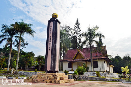
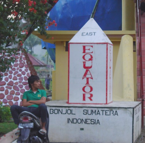
- Bonjol, Sumatra, Indonesia
- Nanyuki, Kenya
- Ol Pejeta Conservancy, near Nanyuki, Kenya
- Nyaharuru-Nyeri Road, Kenya
- Road C77 near Nyahururu, Kenya
- Unnamed Road near Solai, Kenya
- Nakuru-Sigor Road, Mogotio, Kenya
- Road C55 near Nakuru, Kenya
- Eldoret-Nakuru Road, near Baringo Railway Station, Kenya
- Siriba, Kisumu-Busia Road, Kenya
- Nabusanke, Masala-Kampala Road, Uganda
- Kikorongo, Fort Portal - Mpondwe Road, Uganda
- Kisangani-Goma Road near Congo River, DR Congo
- Mbandaka, DR Congo - An historical marker made by the famous Sir Henry Morton Stanley of "Dr. Livingstone, I presume?" fame.
- Makoua, DR Congo
- Unknown Road off Hwy N2 near Nzoghengom, Moyen-Ogooué, Gabon
- Libreville-Lambaréné (N1) Road near Kongo, Gabon
- Islet of Rolas (Ilhéu das Rolas), Sao Tome and Principe Islands
- Macapá, Brazil
- AP-010/Duca Serra Road Intersection Marker near Macapá, Brazil
- BR-174 Road near Rorainópolis, Roraima, Brazil
- BR-307 near São Gabriel da Cachoeira, Amazonas, Brazil
- Unknown Road off E-10 near Marion, Tarapoa, Sucumbios, Ecuador
- Unknown Road off E-10, Sucumbios, Ecuador
- Sun-Dial Monument, Guachalá, Cayambe, Ecuador
- Globe Monument, Guachalá, Cayambe, Ecuador
- Pan American Highway (Garr 35), near Santa Rosa de Pingulmi, Pichincha, Ecuador
- The "un-official" Mitad del Mundo (Middle of the Earth), San Antanio, Ecuador
- The "official" Mitad del Mundo (Middle of the Earth), San Antanio, Ecuador
- The old Equator Monument, Calacalí, Ecuador
1. Bambanipa Equator Monument, Trans Sulawesi Road, Central Sulawesi, Indonesia

Image from Panoramio is by nordinwan

Image from Panoramio is by jj_wind7
3. Santan Ulu Equator Monument, Bontang-Samarinda Road, East Kalimantan, Indonesia

View location in Google Maps

Image from Panoramio is by deddy_darusman
View location in Google Maps
6. Sassa Village Equator Sign, Linga Island, Indonesia
A simple nondescript sign. It can't get simpler than this!

Image from Panoramio is by pinckers
View location in Google Maps
7. Pangkalan Lesung Equator Monument, AH25 (Lintas-Sumatra) Road, Indonesia

Image from Flickr is by Bang Ardin
View location in Google Maps

Image Source: Google Street View

Image from Panoramio is by Azdy elfistoni
Nearby there is another pillar marker;

Image from Panoramio is by elisabeth.poscher
View location in Google Maps
10. Bonjol, Sumatra, Indonesia

Image from Panoramio is by Richard Langford

Image from Flickr is by aikaterinh

Image from Panoramio is by sedas
Pedestrian Bridge

Image from Panoramio is by Hardi Muhardi, S.E.
View location in Google Maps
11. Nanyuki, Kenya

Image from Panoramio is by Cheuk
View location in Google Maps
12. Ol Pejeta Conservancy, near Nanyuki, Kenya

Image from Panoramio is by SergioC76
View location in Google Maps
13. Nyaharuru-Nyeri Road, Kenya

Image from Panoramio is by vividman
View location in Google Maps
14. Road C77 near Nyahururu, Kenya

Image from Panoramio is by Eyad Al Araj
View location in Google Maps
15. Unnamed Road near Solai, Kenya

Image from Panoramio is by TheStas
View location in Google Maps
16. Nakuru-Sigor Road, Mogotio, Kenya

Image from Panoramio is by roks
View location in Google Maps
17. Road C55 near Nakuru, Kenya

Image from Panoramio is by BurtsevAlexey
View location in Google Maps
18. Eldoret-Nakuru Road, near Baringo Railway Station, Kenya

Image from Panoramio is by gruntie
View location in Google Maps
Credits for finding this location is to smask, Member Google Earth Community Forums. Thank you smask.
19. Siriba, Kisumu-Busia Road, Kenya

Image from Panoramio is by Roloon

Image from Panoramio is by darko.paradi
View location in Google Maps
20. Nabusanke, Masala-Kampala Road, Uganda

Image from Panoramio is by alexluz

Image from Panoramio is by Dave LLOYD
View location in Google Maps
21. Kikorongo, Fort Portal - Mpondwe Road, Uganda

Image from Panoramio is by m.matsumoto
The basic design of this monument is same as the one at Nabasunke, Masala-Kampala Road, Uganda (# 20)
View location in Google Maps
22. Kisangani-Goma (N3) Road near Congo River, DR Congo

Image from Panoramio is by oltma
View location in Google Maps
23. Mbandaka, DR Congo
Mbandaka town was founded in 1883 by Sir Henry Morton Stanley of "Dr.Livingstone, I presume?" fame who had given it the name of "Equateur". Stanley had placed a large "Equator Stone" near the river bank south of the city to mark the point where he believed the Equator to cross the river. It remains there even today. (Source: Wikipedia)

Image from Panoramio is by philKin

Image from Panoramio is by philKin
View location in Google Maps
24. Makoua, DR Congo

Image from Panoramio is by Lydie STUELSATZ-DERBEZ
View location Google Maps
25. Unknown Road off Hwy N2 near Nzoghengom, Moyen-Ogooué, Gabon

Image from Panoramio is by Thomas Tvergaard
View in Google Maps
26. Near Kongo, Libreville-Lambaréné (N1) Road, Gabon

Image from Panoramio is by Yves Galipeau

Image from Panoramio is by bvoneche

Image from Panoramio is by xavinap
View location in Google Maps
28. Macapá, Brazil

Image from Panoramio is by David e Brenna Alves

Image from Panoramio is by Pozzi Sergio
View location in Google Maps
29. AP-010/Duca Serra Road Intersection near Macapá, Brazil

Image from Panoramio is by arcabuz
View location in Google Maps and Street View (There are two markers, one on each side of road. The other one can be seen in this link.)
30. BR-174 Road near Rorainópolis, Roraima, Brazil

Image Source: Google Street View
31. BR-307 near São Gabriel da Cachoeira, Amazonas, Brazil
A small marker with line and explanatory map.

Image from Panoramio is by Rafael Rezende
View location in Google Maps
32. Unknown Road off E-10 near Marion, Tarapoa, Sucumbios, Ecuador

Image from Panoramio is by mKlingsiek
View location in Google Maps
33. Unknown Road near E-10, Ecuador

Image from Panoramio is by Wilman Francisco Criollo Aldaz

Image from Panoramio is by Wacope

Image from Panoramio is by seebub
This monument in the shape of a giant sun-dial is in Guachalá, Cayambe, Ecuador. Reportedly this is the only monument in Ecuador built exactly on the equator line. It is part of Quitsato Project a non-profit project which uses its funds for the investigation of the equatorial line.
View location in Google Maps
35. Globe Monument, Guachalá, Cayambe, Ecuador
A bit south of the Solar Clock monument on Equator there is another monument in the shape of Globe, at Guachalá, Cayambe.

Image from Panoramio is by Joeseph-Cro
View location in Google Maps and Street View
36. Pan American Highway (Garr 35), near Santa Rosa de Pingulmi, Pichincha, Ecuador

Image from Panoramio is by Martin Pazzani
View location in Google Maps
Credits for finding this location is to smask, Member Google Earth Community Forums. Thank you smask.
37. The "un-official" Mitad del Mundo (Middle of the Earth), San Antanio, Ecuador

Image from Panoramio is by mKlingsiek

Image from Panoramio is by rokapi2008
View location in Google Maps
It is worth noting that an ancient Inca archaeological site about 3 kilometres to East, (shown below) is located on the equator itself.


Image from Panoramio is by fernando D

Image from Panoramio is by fernando D
View location in Google Maps
39. The old Equator Monument, Calacalí, Ecuador

Image from Panoramio is by Zsolti a Béka
Its larger giant size replica has been built afresh on the original touristy site at San Antanio, (see # 35) and is called "Mitad del Mundo" (Middle of the World).
________________________________________________________________
Edit Note - June 07, 2016
Based on the comments of smask , following locations have been added and the revised .kmz file uploaded. Thank you smask .
- Murung Raya, Central Kalimantan, Indonesia
- Eldoret-Nakuru Road, near Baringo Railway Station, Kenya
- Pan American Highway (Garr 35), near Santa Rosa de Pingulmi, Pichincha, Ecuador
________________________________________________________________
Copyright: Images from Flickr / Panoramio are under the copyright of their owners. Screen captured image from Google Earth / Google Maps and Street Views are under the copyright of Google. Actual terms of copyright/reuse is available in the source link given below each image.


