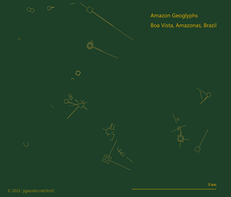
Full Member
November 2015 - Nov 27, 2015 21:55:18 GMT
|
Post by archaeo on Nov 27, 2015 21:49:10 GMT
|
|
Full Member
November 2015 - Nov 27, 2015 21:55:18 GMT
|
Post by archaeo on Feb 26, 2016 19:55:45 GMT
Research continues (440 geoglyphs), especially as more areas have high resolution imagery for the first time. To the south in Amazonian Bolivia, an area rich in visible, ancient anthropogenic earthworks, this particular field line area caught my attention as a unique human land formation. Are these remains of ancient canals and raised beds? For lack of a proper name, I reference a local place name, Curichi Estabi. The town of San Borja, Beni is nearby. To the ESE, I'm now placemarking the Llanos de Moxos cultural expression with monumental mounds and extensive canals. I'm also researching the zanjas (the local term for ring ditch geoglyphs) to the NE around Baures. I highlighted the major lines. Zoom in in Google Earth to see what I assume are raised beds for agriculture between the large canals for transport and drainage. Let me know if you have further data on this location. I'm reading Bolivian Amazon archaeology literature now, will update if I find more about this site. What's under the trees? Are the elevated areas also made by humans? 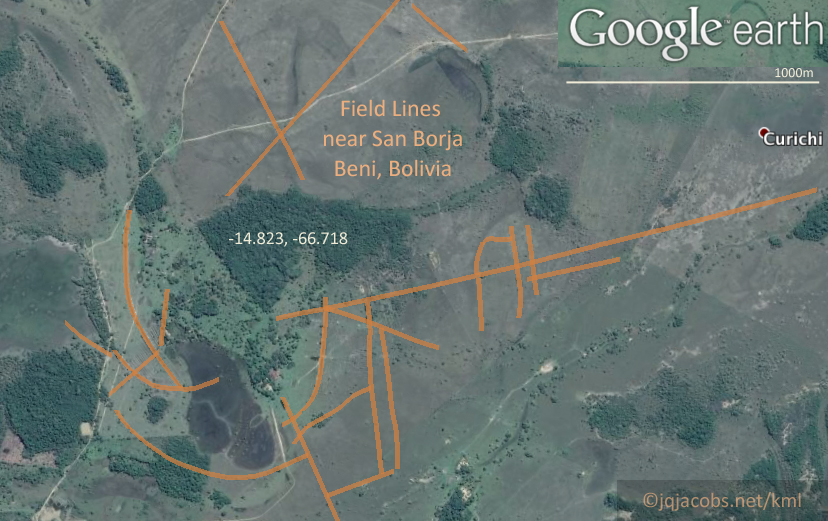 Attachments:curichi.kml (14.59 KB)
|
|
Full Member
November 2015 - Nov 27, 2015 21:55:18 GMT
|
Post by archaeo on Jan 1, 2018 4:45:43 GMT
|
|
Newbie
October 2019 - Nov 3, 2019 23:26:04 GMT
|
Post by mimi76 on Oct 30, 2019 10:05:33 GMT
|
|
March 2015 - Jan 23, 2023 9:58:32 GMT
|
Post by Admin on Oct 30, 2019 10:22:25 GMT
Welcome back mimi76. Thanks
|
|
Master Cartographer
April 2015 - Nov 24, 2024 8:27:42 GMT
|
Post by syzygy on Oct 30, 2019 14:43:37 GMT
hi and welcome (back?) mimi76! thanks for the additions! - my favorite new site is this earthwork complex at >>10°22'28.94"S, 67°25'48.47"W<< 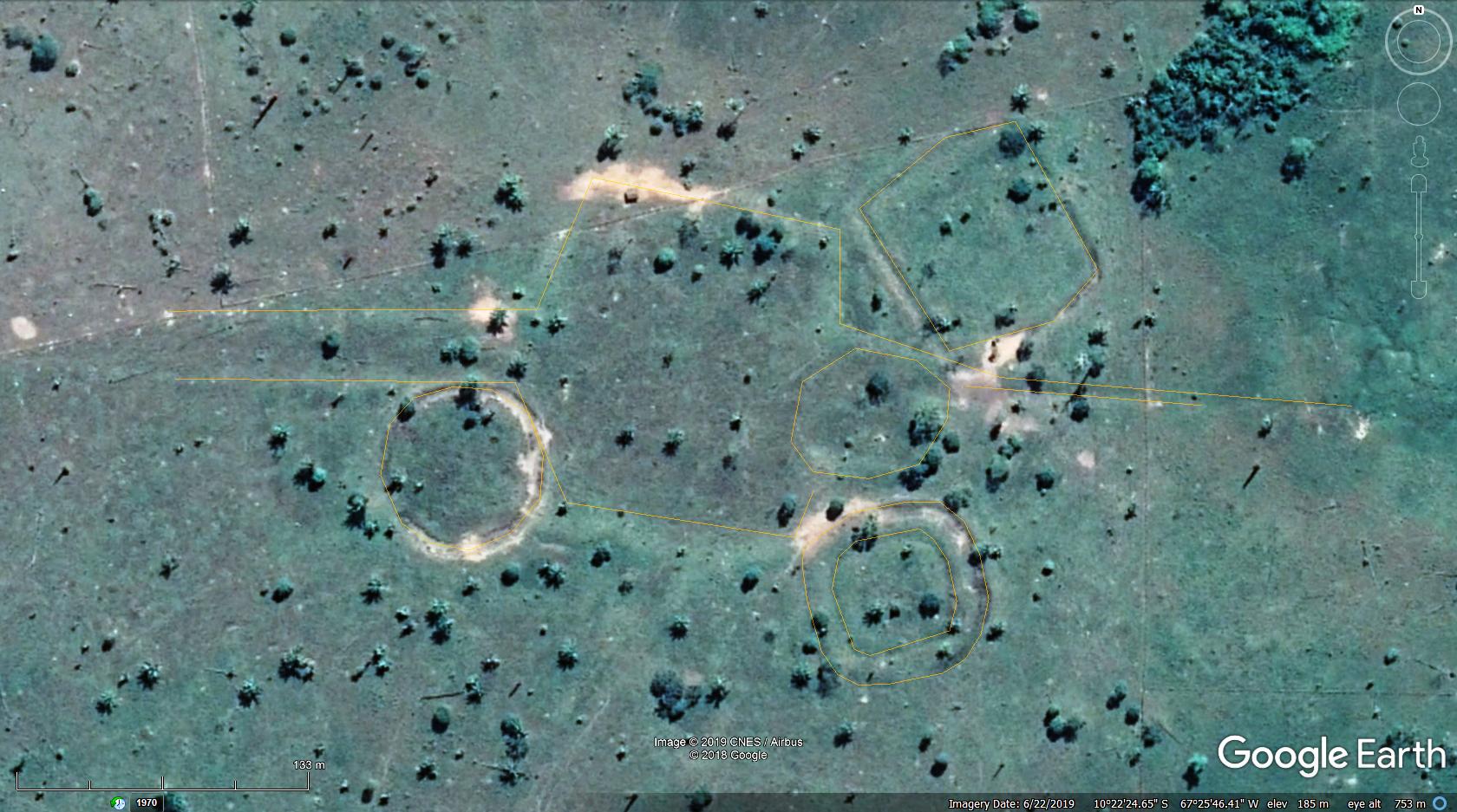 (orange outlines (as archaeo's style) were made by me and I can attach only this) amazon geoglyph lines xmpl.kmz (1.72 KB) best! g |
|
Newbie
October 2019 - Nov 3, 2019 23:26:04 GMT
|
Post by mimi76 on Oct 31, 2019 7:46:41 GMT
|
|
March 2015 - Jan 23, 2023 9:58:32 GMT
|
Post by Admin on Oct 31, 2019 7:55:45 GMT
Still there, make sure you have Google earth community on in the layers.
|
|
Master Cartographer
April 2015 - Nov 24, 2024 8:27:42 GMT
|
Post by syzygy on Oct 31, 2019 15:28:40 GMT
also keep kml files by archaeo on in the Places.
also further duplicates with those marks.
|
|
Full Member
November 2015 - Nov 27, 2015 21:55:18 GMT
|
Post by archaeo on Oct 5, 2021 15:02:17 GMT
I update my main placemarks file periodically, recently several times a year. When I update a regional file I also add the update to the main file.
I'm still waiting on Google Earth to update imagery in several parts of the geoglyph region with imagery clear enough to see geoglyphs.
|
|
Master Cartographer
April 2015 - Nov 24, 2024 8:27:42 GMT
|
Post by syzygy on Oct 5, 2021 16:41:47 GMT
ZoomEarth does not help where you'd need better resolution?
Sometimes BingMaps also displays even different imagery.
|
|
Full Member
November 2015 - Nov 27, 2015 21:55:18 GMT
|
Post by archaeo on Oct 12, 2021 14:58:29 GMT
Yes, I've found satellite imagery with better resolution for some areas, but the workload increases, tools are absent, and an inconsistency in method is a concern too with multiple platforms performing the image placements. If this was a higher priority for me, I'd do the work. Meanwhile, I continue trying to be patient, frustrated year after year as I check for updates. |
|
Full Member
November 2015 - Nov 27, 2015 21:55:18 GMT
|
Post by archaeo on Dec 7, 2021 7:54:24 GMT
..... my favorite new site is this earthwork complex at >>10°22'28.94"S, 67°25'48.47"W<< While re-surveying the newer satellite imagery, and there is a lot of area updated across the geoglyph region, I noticed this site looked bulldozed and reported it to Brazilian authorities. Their reply included the site name, which led to the publicity about the destruction. Another archaeologist saw the satellite image update first and had beat me to reporting it. Charges were already filed. ![]() "Referido sítio arqueológico é denominado de sítio arqueológico Fazenda Crichá" Translation by Google:
MPF – The Federal Public Ministry (MPF) initiated a public civil inquiry and requested the Federal Police to initiate a police inquiry to investigate the damage caused to an archeological site located at Fazenda Crichá (current Fazenda Campo Grande), located in the municipality of Capixaba, a 70km from Rio Branco, capital of Acre, as well as to seek civil and criminal liability for such damages.
The measures were taken after receiving an inspection report from the National Historical and Artistic Heritage Institute (Iphan) and, later, from a complaint by researcher Alceu Ranzi, reinforcing the seriousness of the issue.
The purpose of the civil inquiry is to determine the damage caused by human action in this specific case .... source
You can see the difference using Google Earth's Historical Imagery tool. Reportedly, the damage is not repairable. There are other news articles in Portuguese, so use a translation browser to search sítio arqueológico Fazenda Crichá.
|
|
Full Member
November 2015 - Nov 27, 2015 21:55:18 GMT
|
Post by archaeo on Dec 31, 2021 1:45:28 GMT
Just finished uploading the revised files, now over 1,100 geoglyphs, zanjas, and mound villages, doubling the number from three years ago. The ArchaeoBlog is the best starting point for more info and the downloads. I finally lost patience waiting a decade for some areas to update and screen captured from zoom.earth and satellites.pro to place overlay images in Google Earth, a lot more work and MBs. I can share those KML overlay files and graphics (now 336 MBs) with researchers, but there are copyright issues so they are not online. You have to copy my lat/lon numbers and go to the other apps to view the geoglyphs not yet seen in Google Earth.
Apple maps was useful to view some places, but it is a useless app, not even a way to see coordinates. Bing helped too, once in a while providing a different satellite image and local addresses for naming. I have resurveyed almost everywhere since the last major update three years ago, first focusing on the best updated imagery. There were some real surprises, not just the numbers but also the sizes, new impressive whoppers and some concentrations. All the files are now synchronous, including the main Ancient Monuments KML (except w/o the geoglyph surveys folder). So you can sort by size in the amazon_geoglyphs.xls and paste the coordinates in Google Earth to see the largest ones.
I added a new feature developed to readily see the geoglyph pattern and to create graphics, new backgrounds to overlay the satellite imagery in three colors (with instructions). There is even a deskpicture version in blueprint color, 2560 x 1440 pixels. Perhaps the best new feature is some placemark balloons have quotations from academic articles about the site's research, with links to the articles. I really like geolocated information. In the Google Earth places menu, just look for the geoglyph placemarks with balloon background colors to readily find them. Enjoy, and feedback appreciated. As always, my contacts are kept current on my domain contact page.
|
|
Newbie
December 2021 - Jan 7, 2022 12:59:03 GMT
|
Post by manard on Dec 31, 2021 13:04:45 GMT
Hello Archeo,
Have you tried using JOSM which allows the display of satellite maps from Bing and Maxar? You need to convert the kml file to gpx format.
With a web browser there is also GPX Studio : gpx.studio/ with Mapbox satellite
Have a good try
|
|
Full Member
November 2015 - Nov 27, 2015 21:55:18 GMT
|
Post by archaeo on Dec 31, 2021 17:24:21 GMT
Yes, gpx.studio/ does offer another set of satellite images, usually the same ones of course, and I can create .gpx files and extract their coordinates in a text editor. Their open topo map actually has some geoglyph outlines, but the topo DEM reflects forest elevations, not the ground, so it appears as if there are massive geometric platform mounds near the geoglyphs.
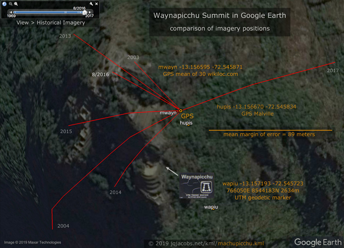
Google Earth Pro supports .gpx and I import hiker GPS tracks to obtain data, albeit there are a lot more Machupicchu tracks than geoglyph hikers. I did a crowdsourced averaging to determine the summits of Waynapicchu and Machupicchu mountain, using up to n=30 tracks. If you view Waynapicchu in Google Earth and slide the historical imagery tool, the mountain really jumps around dramatically due to the various oblique views of vertical terrain.
Is there a free download at Maxar? I see their low resolution tiles and their poor coverage of the geoglyphs area. Maybe I need to explore their site more, but they seem useless. Google Earth has been using their high resolution satellite images for a while now.
|
|
Full Member
November 2015 - Nov 27, 2015 21:55:18 GMT
|
Post by archaeo on Apr 19, 2022 16:34:26 GMT
Update, I'm adding local names of the geoglyphs to the KML placemarks as I acquire them. I found several new ones after finally buying Dr. Schaan's "Sacred Geographies" book and when web searching one of the names stumbled upon Schaan, et.al. Ninety excellent aerial photographs published in a 2007, now online in PDF:
Arqueologia da Amazônia Ocidental: Os Geoglifos do Acre.
I just uploaded revised versions of the KML and XLS, and will add more content to the HTML soon regarding new references.
|
|
Master Cartographer
April 2015 - Nov 24, 2024 8:27:42 GMT
|
Post by syzygy on Apr 19, 2022 23:25:30 GMT
Update... Ninety excellent aerial photographs published in a 2007, now online in PDF:
Arqueologia da Amazônia Ocidental: Os Geoglifos do Acre.
... Thanks for this astonishingly cool stuff! The first time I can see them as real objects, not "only" as processed satellite data. Breathtaking archaeological structures! |
|
Full Member
November 2015 - Nov 27, 2015 21:55:18 GMT
|
Post by archaeo on Apr 22, 2022 6:34:50 GMT
Photo researching on Instagram today:
For coordinates, see image comments or text search the KML in a simple text or XML editor. Might have to try Flicker next, new images reveal more data and details.
|
|
Full Member
November 2015 - Nov 27, 2015 21:55:18 GMT
|
Post by archaeo on Jun 17, 2022 6:57:03 GMT
Almost finished editing the bolivia.kml, file size has doubled, found far more than expected and more than expected higher resolution imagery. Will be online after more reviewing for bugs. Now 6,000 placemarks, 2.5 MB.
Anyone know the terms for using zoom.earth images? Are they shareable?
Check out an area I had placemarked years ago in Google Earth which has updated, far better resolution today. The raised fields even look 3D: -14.8256, -66.7112.
ON EDIT: I intended to post this in the Bolivia thread, very late night and exhausted I guess.
|
|
Master Cartographer
April 2015 - Nov 24, 2024 8:27:42 GMT
|
Post by syzygy on Jun 17, 2022 18:17:53 GMT
For ZoomEarth copyrights I give creadit as:
Image © ZoomEarth / Maxar... or other displayed satellite company name.
The same imagery on BingMaps btw. If I use Bing I also give a copyright to Microsoft.
..
Thanks for the frequent, great update posts!
|
|
Full Member
November 2015 - Nov 27, 2015 21:55:18 GMT
|
Post by archaeo on Oct 6, 2023 2:00:19 GMT
I've recently edited my online KML and XLS files, everything is synched. Just in time for this surprise publication today, which will generate traffic on my domain. More than 10,000 pre-Columbian earthworks are still hidden throughout Amazoniawww.science.org/doi/10.1126/science.ade2541I doubt they are correct and the title reads as fact rather than a prediction they are making. And, they should have checked my data before saying they discovered something as it seems I already have one of their discovered geoglyphs placemarked. Some expert archaeologists think we have found the majority of the geometric earthworks, which I questioned. So I did some quick checking of how much forest remains in areas of probable geoglyphs. Off the cuff estimate, the 1,000 plus we have placemarked are about half of them. So, to quote another authority from today, "Looks like they accidentally added an extra zero." That's going to be close to the truth in my view. Download my latest versions here: jqjacobs.net/archaeology/geoglyph.html |
|
Full Member
November 2015 - Nov 27, 2015 21:55:18 GMT
|
Post by archaeo on Aug 29, 2024 1:39:40 GMT
Wow, Google Earth has been busy updating with great new satellite imagery from just the last few months, perfect timing for seeing the earthworks as pastures are no longer just solid green and overgrown. So I've been busy too, in August I found another 60 geoglyphs and updated a bunch more. We now have databased 1,287 geoglyphs in Acre, Amazonas, Rondonia, and Beni. There are a bunch more to the east in Mato Grosso. I expect to see more satellite imagery updating with the new great new high resolution photos soon. I found a good link to see where the updates are: earth.google.com/web/@-9.84277167,-67.9145614,16.90470027a,636495.51121272d,35y,0h,0t,0r/data=OgMKATA |
|
Full Member
November 2015 - Nov 27, 2015 21:55:18 GMT
|
Post by archaeo on Sept 7, 2024 16:29:57 GMT
|
|


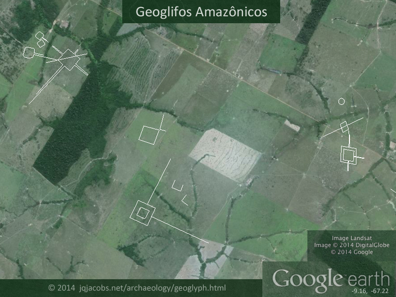

 I've just got back to hunting these. I've found a bunch of as yet unmarked ones although you may already know about them.
