

Post by TomKjeldsen on Sept 25, 2015 14:07:01 GMT
The Jungfrau railway is an 9 kilometres cog, toothed railway of which the top 7 kilometres is inside a mountain tunnel. The railway climbs almost 1400 altitude meters (4600 ft). The railway inside the Eiger and Mönch mountain massive include 2 active stations, the "Eigerwand railway station" inside Eiger mountain, which offer an impressive view from and of the 1800 m (5900 ft) Eigerwand ("Eiger North wall") and the "Eismeer railway station" on the col between Eiger and Mönch with a spectacular view of the Eismeer ("Icesea") Grindelwald-Fiescher glacier. The railway ends below the Sphinx Observatory at the Jungfraujoch ("Jungfrau col") railway station, the highest railway station in Europe at 3454 m (11333 ft).
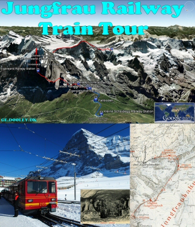
Bigger picture
About the "Jungfrau Railway Train Tour": The tunnel (red) track/path is not precise, mostly an outline, due to no found official altitude and position data avaiable. Station positions along track/path should be fairly close to real world. Recommended to be viewed as a 'Play tour' in Google Earth with the '3D buildings' and terrain layer enabled and a viewing angle above 80 degrees for touring track/path. To adjust viewing angle, choose menu 'Tools', 'Options', Click the tab 'Touring' and change the 'Camera Tilt Angle' to above 80 degrees. The default is 60 degrees. To play a specific path track, mark the 'three dot icon' path track, press the 'Play tour' option and enjoy the train ride. Tour and track creator: Tom Kjeldsen, created april 2013.
Youtube stuff below: (sorry for video background music, can really tend to be a bit too...:-)
Jungfrau - The Top of Europe
The Jungfrau Railway - A Pioneering Work
Download a identical copy of the attached file below from here (suitable for non Google Earth Community members)![]()

This post is a re-post of this original 2013-04-21 Google Earth Community post![]()

Bigger picture
About the "Jungfrau Railway Train Tour": The tunnel (red) track/path is not precise, mostly an outline, due to no found official altitude and position data avaiable. Station positions along track/path should be fairly close to real world. Recommended to be viewed as a 'Play tour' in Google Earth with the '3D buildings' and terrain layer enabled and a viewing angle above 80 degrees for touring track/path. To adjust viewing angle, choose menu 'Tools', 'Options', Click the tab 'Touring' and change the 'Camera Tilt Angle' to above 80 degrees. The default is 60 degrees. To play a specific path track, mark the 'three dot icon' path track, press the 'Play tour' option and enjoy the train ride. Tour and track creator: Tom Kjeldsen, created april 2013.
Youtube stuff below: (sorry for video background music, can really tend to be a bit too...:-)
Jungfrau - The Top of Europe
The Jungfrau Railway - A Pioneering Work
Download a identical copy of the attached file below from here (suitable for non Google Earth Community members)
This post is a re-post of this original 2013-04-21 Google Earth Community post

