Newbie
July 2015 - Jul 29, 2015 23:24:14 GMT
|
Post by clkruse on Jul 28, 2015 18:30:00 GMT
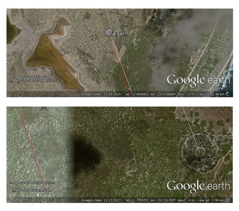
A few months ago I found this arrow while browsing imagery on Kiritimati Island. I took a screenshot, but sadly I can't find the location on the map anymore. Anyone know what it could be, or how to find it again?  |
|
Senior Member
Backyard Astronomer
April 2015 - Jan 25, 2016 4:03:31 GMT
“ Languishing in Twentynine Palms „
|
Post by Gregg1956 on Jul 29, 2015 12:34:47 GMT
I suspect this had something to do with the nuclear tests conducted over the island. [source] It may have been a target or navigational aid. I found it on the North East Point of the island. Target.kmz (665 B) |
|
Cartographer
April 2015 - Nov 3, 2024 2:30:25 GMT
|
Post by washi on Jul 29, 2015 14:00:23 GMT

Well done, Gregg! I think your guess about the origins of the arrow is an excellent one. It may or may not have anything to do with the arrow, but the arrow nearly aligns with a double-circle "bulls eye" in the southeast. |
|
Master Guide
March 2015 - Jan 20, 2022 4:27:51 GMT
|
Post by Hill on Jul 29, 2015 16:41:13 GMT
While no nuclear devices were detonated directly over the island, the arrow and bulls-eye line up with the area where many tests took place nearby at sea. Tests were airdrops or suspended from a balloon. The first group of tests in 1957-8 were directly in line with the arrow. Just a guess but maybe bombs were to be dropped as the plane passed over the "bulls-eye". Or the bull's-eye may be the site of some sort of memorial.  Nuclear test location source Nuclear test location source |
|
Newbie
July 2015 - Jul 29, 2015 23:24:14 GMT
|
Post by clkruse on Jul 29, 2015 23:06:04 GMT
You guys are incredible. I went from being completely bewildered about the source and location of the arrow, and now I have what might be a complete story.
Thanks for satiating my curiosity!
|
|


