Thousands of user discoveries on and information about Earth and other planets
shared, discussed, analyzed in the Google Earth Community forums.

Join the Community and share your discoveries and knowledge,
contribute to the ongoing information exchange.

Join the challenge

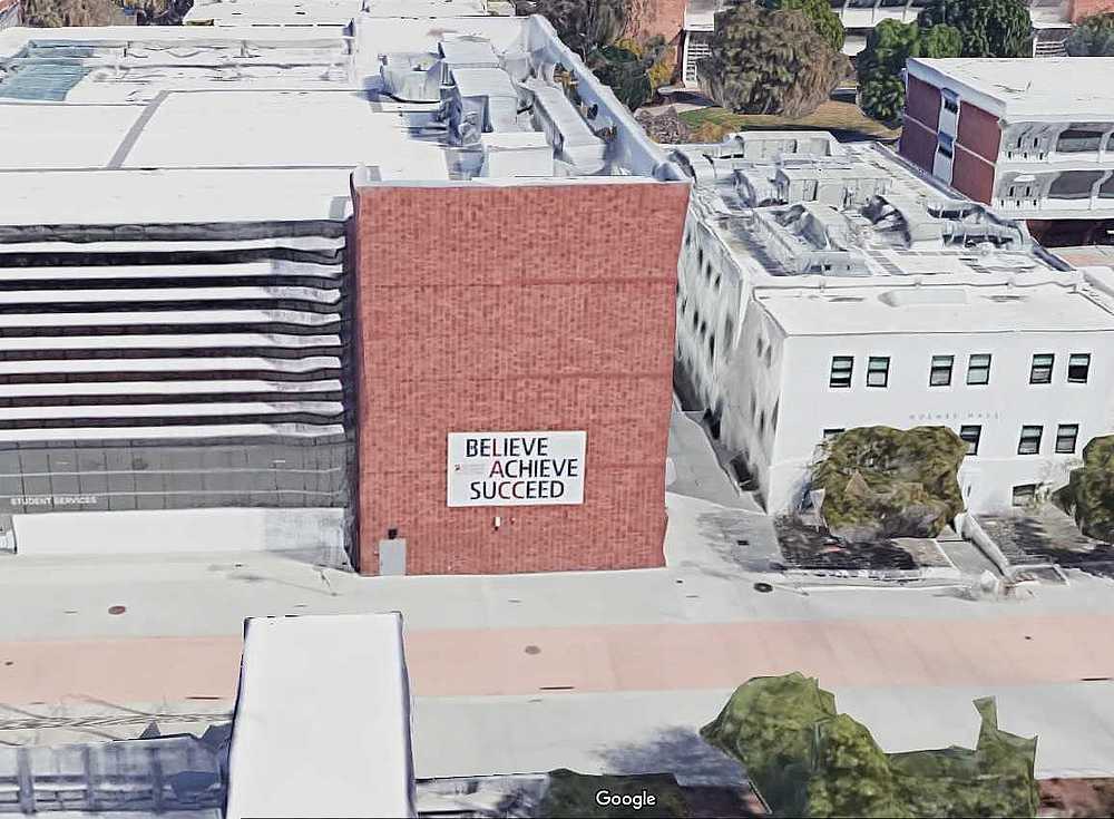
Believe Achieve Succeed - Hint by CuriousJM
While searching for this elusive hand;


I came across this slogan on a wall;


GE/GM 3D of the slogan please. Kudos if you can find the elusive hand.

Join the challenge

Chimney by CuriousJM


Please post a closeup or with trees in front GSV/Bluedot so that it is not reverse Searchable. Thanks.

Join the challenge

Covered Wagon (ANSWER) by dagger66
Street View or Blue Dot.

Blue Dot View.


Street View.


A selected information on geography

Hawaiian-Emperor seamount chain by TomKjeldsen
The Hawaiian-Emperor seamount chain is an over and under water mountain chain composed of the Hawaiian Ridge, consisting of the islands of the Hawaiian chain northwest to Kure Atoll, and the Emperor Seamounts, a vast underwater mountain region of seamounts along a line southeast to northwest beneath the northern Pacific Ocean. The seamount chain, containing over 80 identified undersea volcanoes, stretches over 6400 kilometres (4000 miles) from the Kuril-Kamchatka Trench in the far northwest Pacific to the Loihi seamount, the youngest volcano in the chain, which lies about 35 kilometres (22 miles) southeast of the Island of Hawaii. The Hawaiian Islands are that portion of the Hawaiian-Emperor seamount chain that projects above sea level.


bigger image/collage

The Hawaiian-Emperor seamount chain is a subducting seamount chain on the Pacific tectonic plate, moving at absolute velocity of 8,10 centimeters (3.19 Inches) per year from SE to NW, being subducted beneath the Okhotsk tectonic plate where the plates meets and form the Kuril-Kamchatka Trench. At this point the seamounts end up their more than 80 million years of existence and travel across the Pacific tectonic plate, from their birth as a Shield volcano above the Hawaiian hotspot, now being pressed down into the trench under the Okhotsk plate.

The amount of lava erupted over time to form the Hawaiian-Emperor chain is calculated to be at least 750.000 cubic kilometers, 180,000 cubic miles. If all this material was spread over the 10432 km² Hawaii island it would be covered with a layer of lava at least 70 km (44 miles) thick! This is more than 9.375.000 cubic meter or 331,075,000 cubic feet erupted every year! More than 0,3 cubic meter or 10.5 cubic feet every second!

A sharp bend in the chain indicates that the motion of the Pacific Plate abruptly changed about 43 million years ago, as it took a more westerly turn from its earlier northerly direction. Why the Pacific Plate changed direction is not known, but the change may be related in some way to the collision of India into the Asian continent, which began about the same time.

About the "Hawaiian Emperor seamount chain" tour collection: Take this tour displaying more than 80 million years of volcanic activity combined with mountains moving more than 6400 km (4000 mi) along with the tectonic movement. Collection creator: Tom Kjeldsen, ge.dooley.dk, created December 2009. Recommended to be viewed as a 'Play tour' in Google Earth with terrain and ocean layer enabled.


Download a identical copy of the attached file below from here (suitable for non Google Earth Community members)


This post is a re-post of this original 2009-12-12 Google Earth Community post


Attachments:

Hawaiian-Emperor-seamount-chain.kmz (1.17 MB)

More datasets are needed. Do you have any on your own to share?

Territories and Flags by tek
Most of the links are broken due to the update of the web site the files were located. Rather than fixing them, I prefer to spend my time on keeping on a new version. So, revival of the attachment will take some time. Thank you...


territoriesandflags

Placemarks do not claim the territory it is pointing is a country or is independent. Nor do the collection claim it is containing ALL the territories on the Earth.
They are just derived from their existences in files of UN, EU, UNICEF, and CIA web sites.

Updates will cover reorganizing the collection with more respect to dependencies and will include sub-national/-state territories. ...and will be bound to UN records, instead of CIA's.

The file attached is generated from the said sources, combined and processed in xls2kml and is NOT a copy of the collections attached in the old GEC (by ink_polaroid, zmarties, Herrminator, and other lesser files). Thanks for the efforts and letting us enjoy their work in times.

Attachments:

territoriesandflags.kml (1.64 MB)

The airplanes collection
composed of airplanes discovered by users on both Google Streetview (SV), Photo Sphere (PS) (ground level views), and Google Earth (top down views).
The file is updated every month by SpiderX22.
The Boeing B-29 Superfortress collection
composed discoveries by users.
Updated by v6srs.
The biggest ships collection
composed discoveries by users.
Updated by SpiderX22.
The huge and weird things collection
is compiled in its own UTF forum.
Explore the "Earth forums"
to find out more.
Let us know what happened or is going on
in your neighborhood or in your country!

A selected discussion you may be interested

Inter-Dimensional Hole near 29 Palms by scraps
Very bizarre as the stars underneath remain stationary when you pan around the 'hole' and you can even zoom right into it.

The 'hole' disappears and all seems normal when you click on the time slider.


Attachments:

The 29 Palms Hole.kmz (720 B)

A selected discussion you may be interested

Anamalous Altitude Readings by baumgrenze
I live in Charlottesville, VA in Westminster Canterbury of the Blue Ridge (WCBR) and use the general address of 250 Pantops Mountain Road.

I believe I am getting erroneous altitude readings that are being used by other applications like Contour Map Creator and GMaps Pedometer which perpetuate them.

I will attach 2 images. One shows the altitude readings for an on-campus area. The other shows an image of a 10 ft block retaining wall that holds back a slope with an approximately 5 ft drop from a sidewalk and the end of a building to the top of the wall. Google earth shows a 1 foot altitude difference.


Could this be caused by a tree canopy?

thanks,
baumgrenze

A selected discussion you may be interested

imagery windows by syzygy
interesting, small "window" to another imagery date on GE default view at 51.088786°, 39.104961°
imagery window.kmz (707 B)


+ ! another one with somewhat different shape to South of mark.

now zoom out a bit (to see both "windows") and set Timeslider to 5/11/2016:
a small cloud (at the southern "window") and its shadow (at the placemark's rectangle) appearing.

my question:
is that kind of imagery "healing" made by human or by software? / cool fantasy name would be: CloudKiller 2.0 or would you like better a SightSweeper 3.1...?...(:


A selected conspiracy you may be interested

Buried Structures discovered in the Richat Structure. by case
In the second ring there are at least 7 structures where the tops are now being exposed.  These are substantial in size ranging from 70 to 300 ft. 

[ex]. The most important Acheulean sites and their associated outcrops are found along the north-west of the outer ring, from which Wadi Akerdil heads east and Wadi Bamouere to the west. Sparse and widely scattered Neolithic spear points and other artifacts have also been found. However, since these sites were first discovered by Theodore Monod in 1974,[14] mapping of artifacts within the area of the Richat Structure have found them to be generally absent in its innermost depressions.[/ex]
 
The above also mentions a great deal of flood debris, mud in the area.  Note that in 1974 there were no Satellite programs available to see these buried structures.

There are no known cultures or societies to have existed within this area as the history books fall silent in this area.  Especially, when Northern Africa had a wetter climate, only 5000 years ago.

21° 7'4.04"N 11°16'26.18"W
21° 7'12.62"N 11°16'34.51"W
21° 7'15.42"N 11°16'48.78"W
21° 7'22.90"N 11°16'41.08"W
21° 7'52.48"N 11°16'24.53"W
21° 9'7.56"N 11°16'48.19"W
21° 1'8.49"N 11°26'49.60"W

One structure at the southern entrance was partially excavated which can be observed.  No information is available as to what might have been found, or discovered. 

There is a great debate ongoing as to the Richat being the Ringed City of Atlantis.  Until these sites are excavated it can only be considered Circumstantial evidence.  But in saying that there are other "Water" related irregularities in the Desert that are also circumstantial evidence to support that theory.  And, there appears to be a very old road network present in Mauritania.  It is well defined and segmented and extremely weathered, washed out in places.  This road is present, deep in the desert appearing to come from, and go to, nowhere.  It is not the work of bulldozers as the width is irregular and the edges appear to be made by piling rocks along its length, hand made.

For myself, I believe the "Ringed City" of Atlantis, has been discovered.

Forum Statistics

Total Threads: 9,760
Total Posts: 67,051
Total Members: 7,683
Newest Member: hansfkick8989