Junior Member
September 2021 - Sept 23, 2024 14:04:01 GMT
|
Post by buildsancient on May 1, 2022 10:36:26 GMT
Hmmm...
I would agree with the above. But the Sardinians were also excellent at water management. It might be a clue.
In the case of Pozzo Sacro di Santa Cristina, the outer wall work is shoddy, while the underlying well had absolutely stunning stonework.
It actually looks like the ground structures were added at a later date.
IF this is the case, imagine a drying climate. Perhaps adding a keyhole structure later in desperation made it more likely to direct water into the roof of the well?
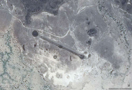
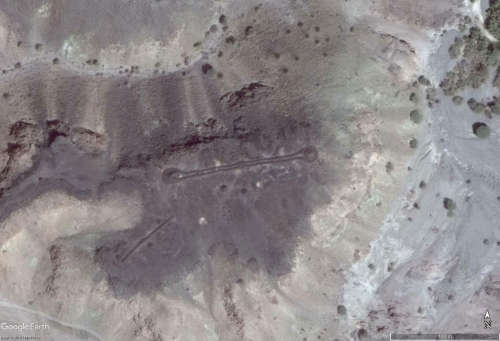
In the case of Saudi and Africa, the climate was wetter back then. Imagine the keyhole and the circle. If you made a grade in the keyhole leading to a pit, it would gather water into it.
The outer wall would prevent junk being blown in due to the wind.
Not in a desert climate, but rather just in an arid one. Occasional rain would top it up.
Grazing animals could go for a drink of water.
Just an idea.
Nowadays the sand covers them. I wonder if anyone has ever bothered to excavate one?
|
|
Full Member
November 2020 - Sept 25, 2024 11:02:30 GMT
|
Post by bemerkenswelt on May 1, 2022 10:47:35 GMT
Very interesting idea, that the keyholes in Sahara could have been worked as cisterns. Why not. On the other hand they found human remains in the central tumulus, so it looks like they have been tombs. But very often the one does not exclude the other. First used as a water deposit, later, when the owner died, they buried him/her there. Ilove practical solutions.
|
|
Junior Member
September 2021 - Sept 23, 2024 14:04:01 GMT
|
Post by buildsancient on May 1, 2022 11:09:44 GMT
Would have made a decent flower bed then too! (-;
|
|
Junior Member
February 2021 - Feb 5, 2021 9:41:19 GMT
|
Post by chriss on May 10, 2022 17:44:33 GMT
More mysterious circles in the Sahara, but not the kind you think
|
|
Master Cartographer
April 2015 - Nov 23, 2024 13:59:51 GMT
|
Post by syzygy on May 11, 2022 22:16:31 GMT
More mysterious circles in the Sahara, but not the kind you think This biggest sand sea of the world if full of various signs, left behind various people of different times and by many occasions... Nice detective story by these - thanks for the interesting video Chris! |
|
Newbie
May 2022 - Mar 14, 2024 2:15:39 GMT
|
Post by osciver on May 14, 2022 16:30:57 GMT
21°39'36.50"N 10°34'23.58"W  Another (possibly) stone structure in the Sahara, East of the Richat. Bout a km long, weaves in and out of the sand, nice smooth curves, uniform width - I say it's an ancient canal! The key is there is other anomalous geology in the very same area.  |
|
Junior Member
September 2021 - Sept 23, 2024 14:04:01 GMT
|
Post by buildsancient on May 15, 2022 11:42:18 GMT
Yep. Know about those.
I have mapped out all the ancient lakes in the region. To the north of the Richat plateau was a very large lake approx 80m deep. The main outlet for this lake travelled through Atar and headed out west. This system was separate from the Tamanrasset system, although it is hard to say because of the dune systems dividing the two. Two further river systems came out of the southern plateau. One was run off from the western section and the other from the Richat structure itself. This though went over a massive waterfall and immediately joined the western run off river which ran south to join up with the Senegal river. This precludes the idea of "Atlantis" in the region. Unless ships can get up vertical waterfalls.
I modelled this using Hydrosheds V1 and HecRas. I am waiting for Hydrosheds V2 to become available so I can refine the data before I release it.
Regarding the linear features, one must remember that the locals have a tradition of dam building to entrain water for crop use. You can see modern versions stretching up from Quadane etc... This tradition goes back thousands of years. Presumably starting up as the lakes began to dry out. While this and geology explains several features, others are more difficult to explain. Such as the curved canal you pointed out, and the northern canal. Hopefully, the new version of Hydrosheds will help with this. Having an upgrade from 30m resolution to 12m.
During the Wet Period maximum, this place would have been utterly spectacular. With literally hundreds of waterfalls pouring off the plateau. Gabor might be interested to know that there was also a lake system down by Tichit. There are dozens of ancient settlements down there too.
|
|
Master Cartographer
April 2015 - Nov 23, 2024 13:59:51 GMT
|
Post by syzygy on May 16, 2022 21:48:38 GMT
... I have mapped out all the ancient lakes in the region.... I modelled this using Hydrosheds V1 and HecRas. I am waiting for Hydrosheds V2 to become available so I can refine the data before I release it. ... Hopefully you're gonna share some kmz version too, also around here on forum! ( ; That would worth a new thread and could be extremely useful for all afro-archaeo-fans. |
|
Newbie
May 2022 - Mar 14, 2024 2:15:39 GMT
|
Post by osciver on May 16, 2022 23:41:48 GMT
Does anyone know anything about this area?  It's covered in strange 'scars' - criss crossing lines that go on for kms and kms.  Some of the lines will stop, jump over a bit, then continue like nothing happened - almost like a section of the line was moved.  It's worth a good going over. It's pretty crazy geology - if that is, indeed, what it is. |
|
Full Member
November 2020 - Sept 25, 2024 11:02:30 GMT
|
Post by bemerkenswelt on May 17, 2022 5:07:32 GMT
I often see linear structures that look to me like ancient "highways" or canals. So many, that I don't think they had so much highways or canals. I think most of it is simply geological patterns that have developed. You would have to ask a geologist. Maybe the solution is much simpler, than we all think.
|
|
Junior Member
February 2021 - Feb 5, 2021 9:41:19 GMT
|
Post by chriss on May 17, 2022 7:19:25 GMT
I think lines are just weathering on bare igneous rock (granite?) along lines of weakness. Mumps are faults. In the hyper-arid Libyan Desert (see current issue of Overland Journal) softer sandstone weathers into shapes you wouldn't believe (often assumed to be volcanic/lava). All this talk of canals reminds me of this crazy story: sahara-overland.com/?s=flooding |
|
Newbie
May 2022 - Mar 14, 2024 2:15:39 GMT
|
Post by osciver on May 17, 2022 17:34:14 GMT
What would a huge area that was once criss-crossed by a grid of canals and plots of land look like after being struck by cataclysm and then buried in the mud and sand for 8 000+ years? imgur.com/a/b6jwwiuA bit like that, I bet! |
|
Full Member
November 2020 - Sept 25, 2024 11:02:30 GMT
|
Post by bemerkenswelt on May 22, 2022 9:47:26 GMT
Did I post the wands in Ethiopia already? To me they look very enigmatic.
Attachments:Stab.kmz (49.07 KB)
|
|
Master Cartographer
April 2015 - Nov 23, 2024 13:59:51 GMT
|
Post by syzygy on May 22, 2022 11:12:35 GMT
Did I post the wands in Ethiopia already? To me they look very enigmatic. Fascinating! - Thanks for add these! |
|
Full Member
November 2020 - Sept 25, 2024 11:02:30 GMT
|
Post by bemerkenswelt on Jun 5, 2022 18:57:26 GMT
Scattered throughout the Sahara are tens of thousands of circular structures that appear to be the remains of prehistoric settlements. In the province of Borkou, south of the Tibesti Mountains, the apparently random distribution of settlements can be linked to the former shorelines of lakes that existed here thousands of years ago. The size of these enclosures starts at around 20 m and can reach up to 200 m. There are no exact dates yet, but some evidence indicates that these structures could be up to 6,000 years old. If confirmed, these artifacts would be among the oldest human made structures in the Sahara.
Attachments:Siedlungen.kmz (84.39 KB)
|
|
Junior Member
July 2022 - Jul 25, 2022 1:19:35 GMT
“ The past is made up of legends and myths „
|
Post by ancientdelta on Jul 16, 2022 16:48:46 GMT
Scattered throughout the Sahara are tens of thousands of circular structures that appear to be the remains of prehistoric settlements. In the province of Borkou, south of the Tibesti Mountains, the apparently random distribution of settlements can be linked to the former shorelines of lakes that existed here thousands of years ago. The size of these enclosures starts at around 20 m and can reach up to 200 m. There are no exact dates yet, but some evidence indicates that these structures could be up to 6,000 years old. If confirmed, these artifacts would be among the oldest human made structures in the Sahara.
Awesome! Check out the post I made in the "Earth Browsing" sub-forum. We should mix all this in a single place...  |
|
Junior Member
November 2022 - Jan 2, 2023 19:21:07 GMT
“ YouTube - Niko Centauri „
|
Post by niko on Nov 29, 2022 3:32:39 GMT
Hi Everybody! I'm new to the forum, but not necessarily to this game. All of my pins are published to Google Maps; in these lists, we have the "Djanet - Tassili N'Ajjer" list, almost primarily in Algeria, with 2462 features mapped here:
and the "Lost Cities of Atlantis" list with another 1450 features in Mauritania, Libya, Niger, Mali, Sudan and Western Sahara here:
If you look at the Tassili N'Ajjer region, you can see I've spent a lot of time there, logging now (they are all numbered on the map in the order they were found) almost 1700 of the "burial mounds with entryway" - to me they look like a mushroom - and if you know the famous cave paintings of Tassili N'Ajjer, it's a UNESCO heritage site that features "The Mushroom Man" and some wild drawings of strange creatures, but representations of mushrooms appear quite a lot.
The other list... well, my hypothesis is that the whole northern continent of Africa was partially submerged first, the waterline reaching inland toward the settlements along the edge of the plateau from Moudjéria to El Medda, West of the Richat. Then, some millennia later, it sank further, leaving only some land exposed. The condition of the surface has similar qualities as rugged bedrock that had been submerged in seawater. There would not be an accumulation of soil, since the sediment travels with the flow and/or currents. There are seashells all across the Sahara, so this isn't so farfetched. The picture looks strikingly similar to the story about Atlantis, doesn't it?
By the way... anybody see this one?
What about this stuff in Niger?
19°14'56.7"N 9°04'55.4"E
19.249069, 9.082043
19°14'07.8"N 8°59'40.5"E
19.235494, 8.994577
Those discs are about 150 ft wide. The discs are all over this area, which is sort of ironic, considering the shape of that landmass. I'm really just getting started in this precise location, so lets see what we find here in Niger!
Basically, the way I approached this was all wrong but, was already heavily invested, so... I used Google Maps to hold all my pins, but it was too late when I found out I could not export the data from "lists" which is what I had built. Now, the only way to get to each of them is to copy and paste each one. That's almost 4000 entries to manually encode again. God help me...
|
|
Junior Member
November 2022 - Jan 2, 2023 19:21:07 GMT
“ YouTube - Niko Centauri „
|
Post by niko on Nov 29, 2022 4:49:11 GMT
bemerkenswelt, I checked out your GoogleEarth collection, very impressive! is anyone keeping/maintaining a master list of sites or features? I would love to contribute 
|
|
Full Member
November 2020 - Sept 25, 2024 11:02:30 GMT
|
Post by bemerkenswelt on Nov 29, 2022 9:39:00 GMT
By the way... anybody see this one?
Yes, I know that, but no idea what it is. For a geologic formation it would be very strange. Nobody I asked had any idea either.
|
|
Full Member
November 2020 - Sept 25, 2024 11:02:30 GMT
|
Post by bemerkenswelt on Nov 29, 2022 9:46:33 GMT
19°14'07.8"N 8°59'40.5"E 19.235494, 8.994577
Those discs are about 150 ft wide. The discs are all over this area, which is sort of ironic, considering the shape of that landmass. I'm really just getting started in this precise location, so lets see what we find here in Niger! ... ![]() I would say platform tumbs or "bazina" tumbs. If you have a close look, you'll see the little dot in the centre.
They are wide spread in Sahara. Attached a kml with only some of my samples. Most of them I have in the big kml of tumuli, amongst all the others.
|
|
Junior Member
February 2021 - Feb 5, 2021 9:41:19 GMT
|
Post by chriss on Nov 29, 2022 10:00:43 GMT
I assumed the Algeria one would be a foggara tunnel irrigation system (like the Persian one) as found not far to the northwest in the Tuat region, but it is too far out. So I thought it might be mineral prospecting. Someone will just have to go and find out!
The Niger one is the famous Adrar Chiriet mountain. Loads of prehistoric relics in that area, from tombs to tiny flint arrowheads, but you never see the former more clearly than on Google Earth.
|
|
Full Member
November 2020 - Sept 25, 2024 11:02:30 GMT
|
Post by bemerkenswelt on Nov 29, 2022 10:13:52 GMT
bemerkenswelt, I checked out your GoogleEarth collection, very impressive! is anyone keeping/maintaining a master list of sites or features? I would love to contribute 
I believe there are many people in the world who collect this for themselves. Sometimes people send me their finds for discussing some questions. There are so many of these remains, that you'll never have a perfect collection.
Yves Gauthier for example, he has thousands more placemarks in his list than I have, and even he says: "Sahara is that big, that you can't find nearly everything.". .
|
|
Full Member
November 2020 - Sept 25, 2024 11:02:30 GMT
|
Post by bemerkenswelt on Nov 29, 2022 10:54:33 GMT
Hi Everybody! I'm new to the forum, but not necessarily to this game.
Welcome as a new player to this club!
.
"burial mounds with entryway" - to me they look like a mushroom - There are some of this "keyholes" or "MTS" as I call them, in which the inner circle is cutted.
Here I can agree that they look similar to a mushroom.
Good idea.
But most of them have a round inner circle.
That doesn't have much to do with a mushroom I think.. There are seashells all across the Sahara, so this isn't so farfetched. Everywhere on earth has been sea in earlier geological ages.
But only 4,000 years ago Sahara was full of lakes and rivers.![]()
So it's normal that you find seashells there that are not "very old". |
|
Junior Member
November 2022 - Jan 2, 2023 19:21:07 GMT
“ YouTube - Niko Centauri „
|
Post by niko on Nov 29, 2022 18:58:27 GMT
One thing is for sure, we don't know much about our ancient past, so it will be interesting to see where we go with all this. Thanks to folks like yourselves, the rest of the world might learn about ourselves, our ancient past, and it will be so relevant in this era of changes.
It seems to me the best thing to collect all the data into one place, meaning not just location data, but elevation, precise orientation, condition, and artistry; then we can all get a better look and play around with sorting it all out. When you take, for example, all of these "mts" tombs (I have 1679 logged), you see that some are just perfect and most are not too high, not too low, on the side of a hill or a ridge, following the rivers or ancient lake shore, and always facing East, but not precisely, and often in groups of 3. Less than half of them appear to have been either vandalized or repurposed sometime in the millennia they have been there. Some have a shoddy look to them as if they were made hastily or with less care. Were they always tombs? In many cases, you can see the ghost of the mts still remains while it was replaced with a disc-shaped tumulus. In many cases also, a crescent or "antennae" has been placed deliberately across the mts.
Were they always burials? To me, they appear to be like a standard, or a flag. High concentration of these "discs" in Niger. No crescents, no mts, just discs everywhere. High concentration of crescents in Mali, no discs, no mts. High concentration of mts in Algeria, but here we find discs, we find "antennae" and we find more signs of vandalism/repurposing/replacement. Could there have been 3 different co-existing mesolithic or neolithic peoples living in North Africa at the same time? Each may have had their symbol, or their flag, and when you consider the actual labor involved in building these things (I work with stone myself) then you wouldn't change or alter one unless there was a good reason for it. Did they have "rulers" that could manipulate masses at their whims? Likely the most practical reason is there was a war or conflict a long time ago, and the area where the mts is found might have been attacked (or taken over) by either the Disc Makers and/or the Crescent Makers, who, for the sake of practicality, installed their "flag" over the other as a sign of dominance. It appears as if the mts always comes first. If we consider that as far as we can tell, the Sahara began its transition to desert some 5000 years ago, the abundant flora and fauna that must have sustained these ancient people would have dwindled, causing stress among the people. Water would have begun to dry up, people would have had to shift and migrate. Perhaps some places were quicker to desiccate than others, so the places that remained green and wet had an influx of migrants who would have brought their "flag" with them.
As far as the sea levels go, or water levels in general, we just don't know conclusively and can dream, but there is evidence out there. The certain species of gastropods I have seen only live in saltwater environments, but yes also MANY freshwater lakes and rivers. Someone just has to go and do the work, there are ways to verify our claims and questions on the ground there. It's just a question of funding to do the work to nail it down.
Would it be possible to train an AI bot to comb satellite data to, say, count ALL the boring tumulus and mark their location and so on?
Ahh, bemerkenswelt, about the"mushroom hypothesis", it just was a coincidence that I was finding a TON of mts in the neighborhood of Tassili N'Ajjer, and as a former psychenaut, the symbol of the mushroom is powerful for those who use it as a medicine!
If I could afford it, I would most certainly fund this research, along with putting a series together (I used to be a photojournalist) to generate more public interest, because African history is human history - we all sprouted from there at one time or another...it is the homeland of all of humanity and right now, it is demanding for attention!
|
|
Junior Member
November 2022 - Jan 2, 2023 19:21:07 GMT
“ YouTube - Niko Centauri „
|
Post by niko on Nov 29, 2022 19:11:02 GMT
19°14'07.8"N 8°59'40.5"E 19.235494, 8.994577
Those discs are about 150 ft wide. The discs are all over this area, which is sort of ironic, considering the shape of that landmass. I'm really just getting started in this precise location, so lets see what we find here in Niger! ... ![]() I would say platform tumbs or "bazina" tumbs. If you have a close look, you'll see the little dot in the centre.
They are wide spread in Sahara. Attached a kml with only some of my samples. Most of them I have in the big kml of tumuli, amongst all the others.
You know I thought the same, but these discs are so large, plus they are put up high and often on a slope so they can be seen from a distance. Hopefully someone got payed to make those, because that looks like a hell of a lot of work  |
|
Junior Member
November 2022 - Jan 2, 2023 19:21:07 GMT
“ YouTube - Niko Centauri „
|
Post by niko on Nov 29, 2022 20:07:24 GMT
I assumed the Algeria one would be a foggara tunnel irrigation system (like the Persian one) as found not far to the northwest in the Tuat region, but it is too far out. So I thought it might be mineral prospecting. Someone will just have to go and find out! The Niger one is the famous Adrar Chiriet mountain. Loads of prehistoric relics in that area, from tombs to tiny flint arrowheads, but you never see the former more clearly than on Google Earth. chriss - those blocks are like 20' wide each with nothing really anywhere around it besides a few stone huts, so it is quite mystifying! Adrar Chiriet looks like the "capital city" of the disc people, doesn't it? They are really into discs there, I mean REALLY into them.
bemerkenswelt - another thought about the mushrooms... mushrooms like psilocybin cubensis appear at first like the central tunnel with the nucleus; then, as they mature, the cap continues to grow and spreads out flat like a disc. The symbol itself looks as if it evolved over time, doesn't it?
|
|
Full Member
November 2020 - Sept 25, 2024 11:02:30 GMT
|
Post by bemerkenswelt on Nov 29, 2022 20:08:19 GMT
It seems to me the best thing to collect all the data into one place, meaning not just location data, but elevation, precise orientation, condition, and artistry; That's exactly what scientists do in their researches and papers.
(I tried to attach a pdf to my answer before, but it didn't work.)
But you'll find links in the internet, like this to DESERT KITES IN SAHARA.
Or libraries of many authors: www.researchgate.net/profile/Yves-Gauthier or independentresearcher.academia.edu/YvesGauthier
.
The databases with all the facts would be very big.
Most scientists keep their finds secret, because they earn money by writing papers and articles.
But now, since Google Earth is free to anybody, it's not easy to have secrets any more.
... following the rivers or ancient lake shore, ... Like most of the enclosures in Borku region.. and always facing East Not always.
Approx. a twenty percent of the "antennae" tombs (crescent, V-antenna, etc.) are facing west.. , ... Less than half of them appear to have been either vandalized or repurposed sometime in the millennia they have been there. Some have a shoddy look to them as if they were made hastily or with less care. Were they always tombs? In many cases, you can see the ghost of the mts still remains while it was replaced with a disc-shaped tumulus. In many cases also, a crescent or "antennae" has been placed deliberately across the mts. Old monuments recycled to build a new monument.
. Were they always burials? Not sure.
Many yes, but also a lot of monuments with unclear purpose.
(that's what scientists tell me). Could there have been 3 different co-existing mesolithic or neolithic peoples living in North Africa at the same time? Each may have had their symbol, or their flag, That is entirely possible or even probable.
Also there are signs, that one type of monument could have developed from the other.
. As far as the sea levels go, or water levels in general, we just don't know conclusively and can dream, but there is evidence out there. The certain species of gastropods I have seen only live in saltwater environments, but yes also MANY freshwater lakes and rivers. Someone just has to go and do the work, there are ways to verify our claims and questions on the ground there. It's just a question of funding to do the work to nail it down. Very true, but at that point the problem starts.
There are not archaeologists enough to do all that work.
And many of the countries or areas are quite dangerous.. Would it be possible to train an AI bot to comb satellite data to, say, count ALL the boring tumulus and mark their location and so on? That's what I thought about very often.
But why count something, if you don't have the opportunity to examine even a small part of it. . Ahh, bemerkenswelt, about the"mushroom hypothesis", it just was a coincidence that I was finding a TON of mts in the neighborhood of Tassili N'Ajjer, and as a former psychenaut, the symbol of the mushroom is powerful for those who use it as a medicine! Maybe an interesting connection to that rock painting of the mushroom-man.
I will have that in mind for the future.. ... to generate more public interest, ... Exactly that was the reason I created my archaeological website. |
|
Junior Member
November 2022 - Jan 2, 2023 19:21:07 GMT
“ YouTube - Niko Centauri „
|
Post by niko on Nov 29, 2022 20:30:54 GMT
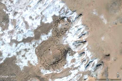
Anyone know what the deal is with these fortress-like things around the Richat?
|
|
Full Member
November 2020 - Sept 25, 2024 11:02:30 GMT
|
Post by bemerkenswelt on Nov 29, 2022 20:41:54 GMT
|
|
Junior Member
November 2022 - Jan 2, 2023 19:21:07 GMT
“ YouTube - Niko Centauri „
|
Post by niko on Nov 29, 2022 21:03:22 GMT
and always facing East Not always.
Approx. a twenty percent of the "antennae" tombs (crescent, V-antenna, etc.) are facing west.***I meant mostly just the "mts" there is only one example that I can think of out of all of those I've found so far that faces a different direction, and that one only leans heavily to the south. The others, you are right, face both east and West, but isn't it interesting that where you see both the Arcs or Crescents there appear to be different "ages", like some are older, some look fresher and more distinct. It reminds me of the account of Herodotus, when he asked the Egyptian priests how old the Great Pyramid was, they replied,"It was built when TWICE BEFORE the sun rises where it now sets and sets where it now rises." Implying the earth flips or flops and reverses course, then back again. Some have thought it refers to the procession of the equinoxes, as in 26,000-year cycles, but what if there is more to that story? We would have no way of measuring that, aside from ghosts that haunt the myths and legends... In our case, the people would build new monuments to face the sun, because the sun is the giver of life in this world, not hard to make a case for sun-worship, especially if the sun (or the earth, rather) was so fickle as to dance like this. "He is NOT happy fellas, we gotta build more monuments, bigger ones this time, guys, or we're done for!". When it shifted back, they built new monuments yet again, since the old ones had been neglected. Plausible? In a way, I hope not... Would it be possible to train an AI bot to comb satellite data to, say, count ALL the boring tumulus and mark their location and so on? That's what I thought about very often.
But why count something, if you don't have the opportunity to examine even a small part of it.Not just to count them, but classify and mark them. With the data generated, one could build a simulation to help determine how the story unfolded over time.
I had no idea you or your group existed! I've been doing this since 2019, and then the pandemic hit and it was the perfect activity. I sure wish I'd known sooner, we could have shared so much! Very happy to meet you all! ... to generate more public interest, ... Exactly that was the reason I created my archaeological website. |
|


