Master Cartographer
April 2015 - Nov 26, 2024 22:38:11 GMT
|
Post by syzygy on Dec 6, 2017 9:35:51 GMT
380 meters diameter: 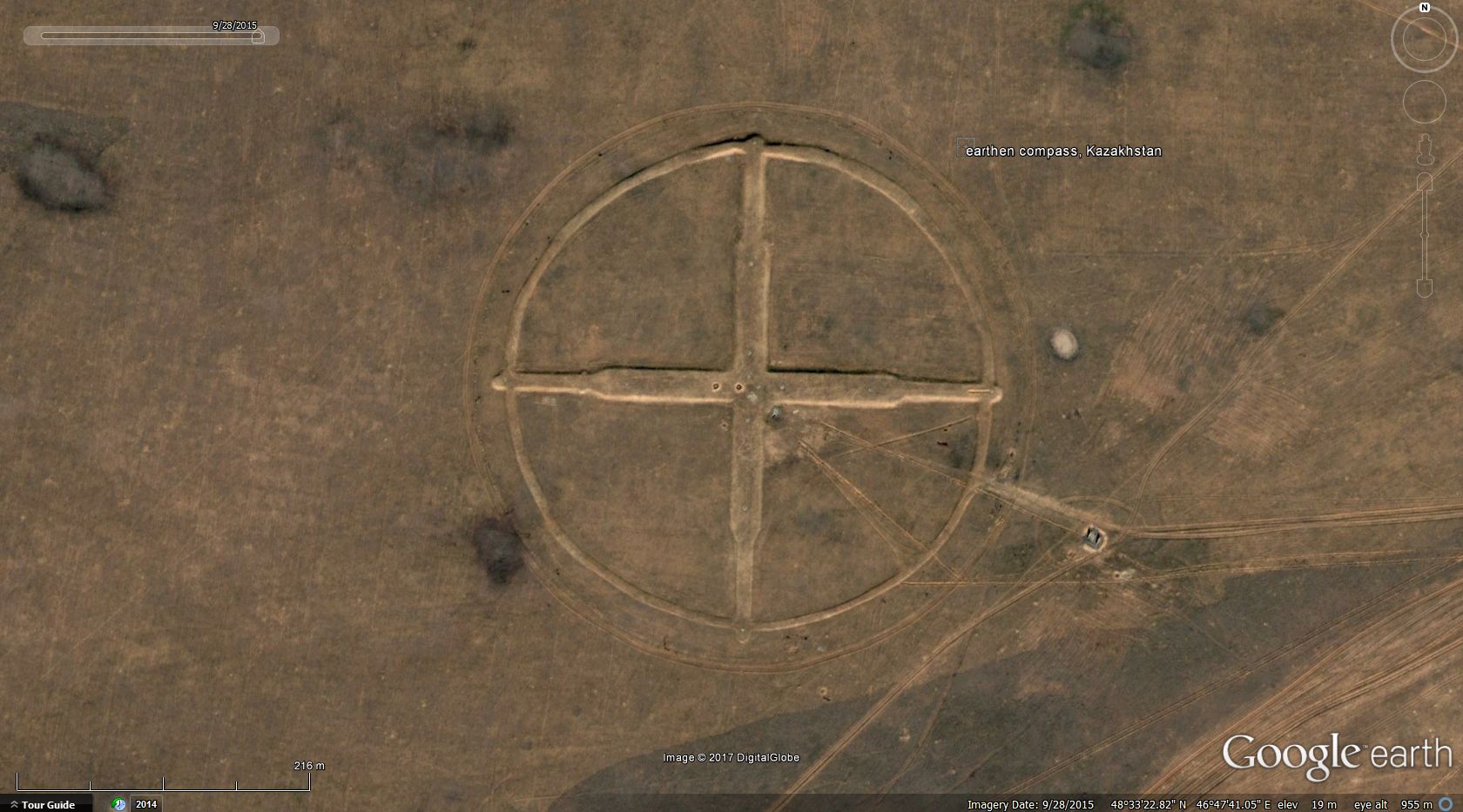 >>48.556045, 46.794889<< on BingMaps (note abandoned control station(?) to E) any info on this?* do any of old GEC fellows around here remember some thread (let it be both from old- or new forums) about such ground compass features on Google Earth? I just cannot find it. *** EDIT: Just have found the same spotting by hhgygy on virtualglobetrotting.com! So that is why it looked so familiar..! ( : How do you know these are bombing targets old fellow? These are too big and way too well-made, if you know what I mean. All the fine details on and around my second finding (lines, blocks, equipment and the abandoned settled site (control station?) nearby again) make me think, these must have served higher purposes than being bombed away... and / or where are the craters then...?! (no bombshells or any other typical signs or scars of military practice sites...) ... * (final) EDIT: explanation and further examples by willi1, below in this thread. These are antenna fields, more precisely two-channel phase measuring direction finder type "Висла", belonged to the system for external flight path measurement of the Soviet air defense. There are some of them. *** Recent stage of updates: Placemarks for 23 sites attached: Visla - antenna fields.kmz (3.82 KB) *** Attached kmz file only available here on the every-time "Live" GE Community Forums, which is now self-sponsored.If You make good use of this dataset, please donate our community! Thank You!
*
|
*** |
|
Master Cartographer
April 2015 - Nov 26, 2024 22:38:11 GMT
|
Post by syzygy on Oct 18, 2021 12:38:04 GMT
Very exactly 850 kilometers far to the East -and some 4 years distance in time- from my first spotting I have found a 2nd structure with the very same dimensions: 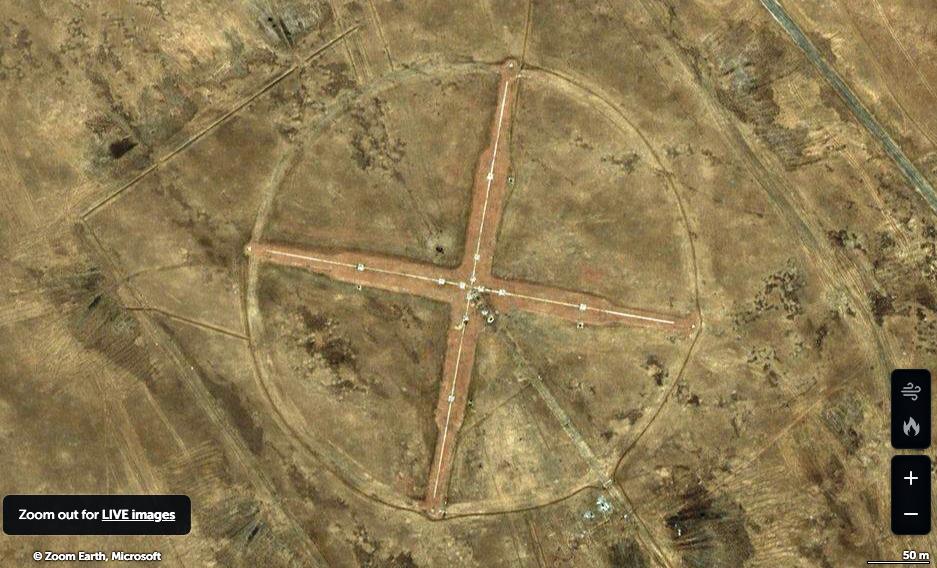 >>48.200146, 58.275733<< on BingMaps Compared with the first one can note that this one looks less worn and ruined also that in this case "compass" points a few degrees off the Northern direction. (NNE) Well - it took me 4 years to spot another example of these huge structures and still I am not closer to the solution... could anyone please speed up this process? ( : Thanks! *** Updated kmz file attached to OP. |
|
Master Gamer
April 2018 - Nov 26, 2024 20:42:29 GMT
|
Post by willi1 on Oct 18, 2021 14:06:12 GMT
... could anyone please speed up this process? We like to do that 
These are antenna fields, more precisely two-channel phase measuring direction finder type "Висла", belonged to the system for external flight path measurement of the Soviet air defense. There are some of them.
Attachments:Visla.kmz (975 B)
|
|
Master Gamer
April 2018 - Nov 26, 2024 20:42:29 GMT
|
Post by willi1 on Oct 18, 2021 14:27:06 GMT
|
|
Master Cartographer
April 2015 - Nov 26, 2024 22:38:11 GMT
|
Post by syzygy on Oct 18, 2021 14:43:26 GMT
Many thanks willi1 ! - Now reception is much clearer!  Your bottomless archives should to be considered as part of the World Heritage btw...!  ... So these (all we have yet) are from Kazakhstan - more examples from any other (post-Soviet) countries anyone? |
|
Master Cartographer
April 2015 - Nov 26, 2024 22:38:11 GMT
|
Post by syzygy on Oct 19, 2021 12:12:31 GMT
Have made a quick search and already could look up 4 more sites. 2 came from simple wikimapia search results and 2 further pieces I thank to this page (rus) where also electrotechnics can be checked on archive photos. 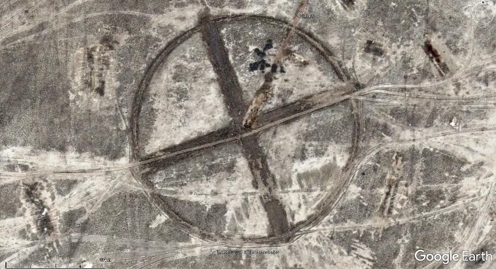 . 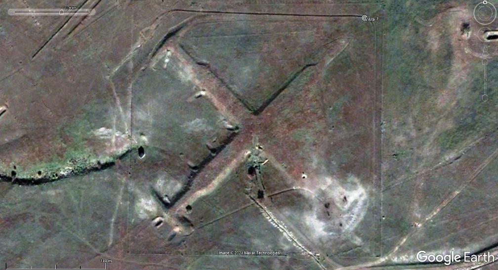 . 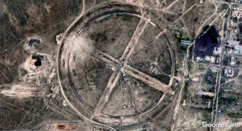 . 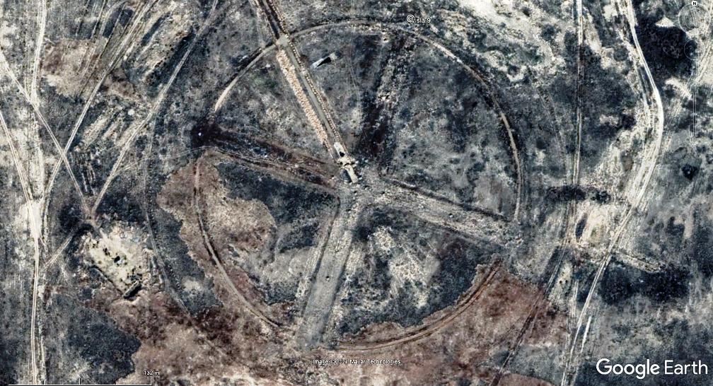 'Visla 7' is on the Krim Peninsula, so the first one that I have found outside Kazakhstan. As I am pretty sure that there are (many?) more Висла locations on the territory of the former USSR, still I ask your help to find more! Thanks! G *** Updated kmz file attached to OP. |
|
Master Gamer
April 2018 - Nov 26, 2024 20:42:29 GMT
|
Post by willi1 on Oct 19, 2021 15:29:52 GMT
|
|
Master Gamer
April 2018 - Nov 26, 2024 20:42:29 GMT
|
Post by willi1 on Oct 20, 2021 9:27:19 GMT
|
|
Master Cartographer
April 2015 - Nov 26, 2024 22:38:11 GMT
|
Post by syzygy on Oct 20, 2021 12:13:02 GMT
Latvia - Great!
Would be not the first thread of mine where you take the first role, even not the first time when I would not mind this at all! ( ;
Thank you Master!
---
Updated kmz file attached to OP.
|
|
Master Cartographer
April 2015 - Nov 26, 2024 22:38:11 GMT
|
Post by syzygy on Feb 18, 2022 12:55:57 GMT
No.12.:From Western Kazakhstan again >>48.171815, 48.595925<<  BingMaps link BingMaps link --- Updated kmz file attached to OP.
|
|
Explorer
April 2015 - Nov 26, 2024 20:37:46 GMT
|
Post by larryc1 on Feb 24, 2022 20:20:49 GMT
Fascinating!
|
|
Master Cartographer
April 2015 - Nov 26, 2024 22:38:11 GMT
|
Post by syzygy on Apr 8, 2022 11:25:20 GMT
No.13.:A ruined site, only 35 kilometers North of placemark "Visla 5" in the collection, on the banks of the same river, E Kazakhstan:  Coordinates: >>48.280572, 53.885271<< -- Updated kmz file attached to OP.
|
|
Master Cartographer
April 2015 - Nov 26, 2024 22:38:11 GMT
|
Post by syzygy on Mar 12, 2024 8:10:05 GMT
No.14.:Following the road from 'Visla 8' to ENE, there is another scruffy site in Zhanaarka District, Ulytau Region, Kazakhstan.  >> 46.245388, 70.924713<< / Instant check: on BingMapsThis is the harvest of the past 2 years! - Slowly but steady...! ( : Anyone to contribute? - Thanks! --
Updated kmz file attached to OP.
|
|
Master Cartographer
April 2015 - Nov 26, 2024 22:38:11 GMT
|
Post by syzygy on Mar 16, 2024 16:22:41 GMT
Thanks for the advice of Vitalij Shuptar, excellent archaeologist and orientalist I met on Instagram (@shuptarography), I did a try with wikimapia and have succeeded again! Two more sites could be added with this update, both from around the easternmost (Balkhash) group. -- No.15.:  GE imagery at >>46.40585, 72.54967<< as Висла-км on wikimapia -- No.16.: BingMaps link BingMaps link at >>46.92151, 70.84367<< as ДФП "Висла - М" on wikimapia -- Updated kmz file attached to OP.-- |
|
Master Cartographer
April 2015 - Nov 26, 2024 22:38:11 GMT
|
Post by syzygy on Mar 20, 2024 14:55:33 GMT
No.17.:From around the "Balkhash group" again.  >> 45.91236, 71.35415<< / Instant check: on BingMapsSorry for the frequent bump of this thread -even it has no sense, being a 'Sticky' one-, but these structures became my most recent obsession... cannot resist doing a quick try to spot one more on every single day... ( : --
Updated kmz file attached to OP.
|
|
Master Cartographer
April 2015 - Nov 26, 2024 22:38:11 GMT
|
Post by syzygy on Mar 21, 2024 14:28:06 GMT
No.18.:Only 30 kilometers southeast of my first spotting now I have found (Googled) this one at Nizhniy Baskunchak, Akhtubinsky District, Astrakhan’, Russia:  >> 48.301777, 46.943661<< / source: yandex.ru--
Updated kmz file attached to OP.
|
|
Master Cartographer
April 2015 - Nov 26, 2024 22:38:11 GMT
|
Post by syzygy on Mar 22, 2024 9:21:30 GMT
Firstly another Google Search finding for today - 60 kilometers SE of Moscow, Russia: No.19.: >> 55.39600, 38.33545<< / source: geocaching.su-- Just before I gave up finding more, I have bumped into a brilliant source at ww2.dk and could add 4 more sites from Kazakhstan: No.20.: >> 46.61905, 70.78124<< / BingMaps linkNo.21.: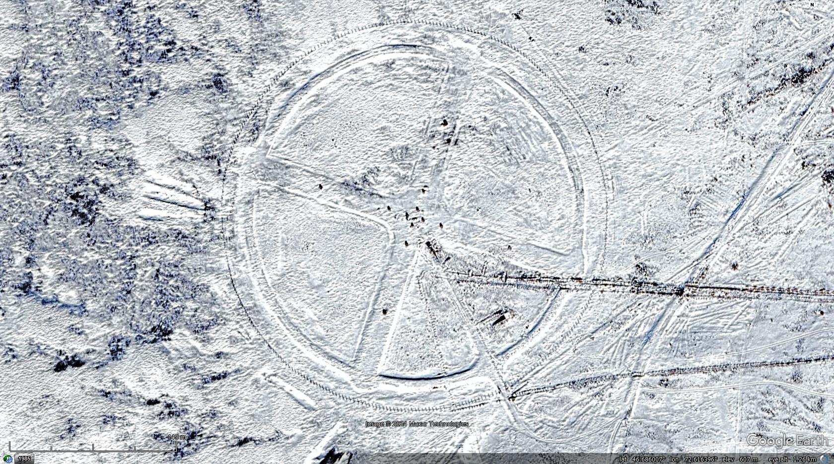 >> 46.68611, 72.61639<< / BingMaps linkNo.22.: >> 47.14028, 69.16722<< / BingMaps linkNo.23.: >> 47.37417, 67.48944<< / BingMaps link-- Slowly I think we're running out of further web-sources, also spotting another site by "random" GE imagery browsing seems to turn difficult... Maybe someone with better luck...? I keep trust in you guys around here on GEC Forums! - You are the best! ( ; Thanks! --
Updated kmz file attached to OP. |
|


