Master Cartographer
April 2015 - Nov 21, 2024 8:06:11 GMT
|
Post by syzygy on Oct 11, 2017 7:27:42 GMT
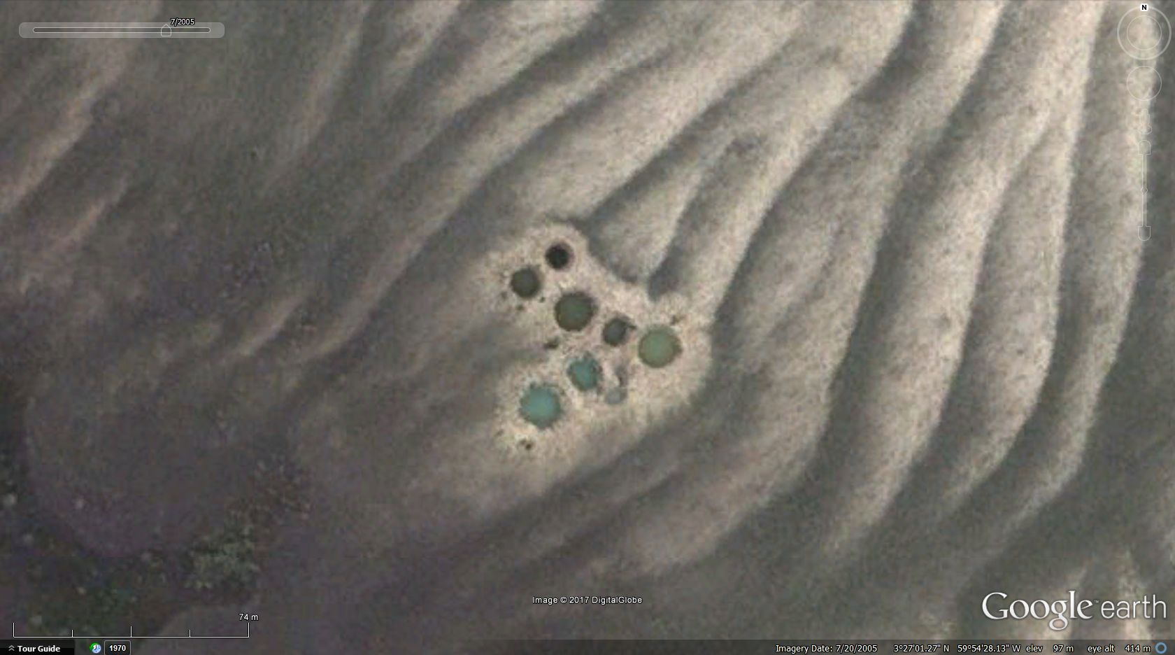
if not enough that all the surrounding area looks like an alien world from above, then here you are these unexplainable, remote holes filled with water! (3 further similar sites with no water in the holes)  full size full size screenshot odd remote holes Brazil.kmz (1.57 KB) any pale ideas? could these be water supply ponds for herded animal? -stange method anyways*! ***
*
therapist: -anyways...
patient: -anyways isn't a word. -you mean anyway.
therapist: -anyway, we are talking about your difficulty making friends, ...
(:
/sorry for off topic rubbish!/ |
|
Full Member
Cartographer
May 2015 - Oct 21, 2024 18:35:52 GMT
“ Fellow Royal Canadian Geographical Society „
|
Post by jeanthie on Nov 14, 2018 13:51:22 GMT
Syzygy, I believe they are a cluster of bomb craters.
Jean
|
|
Master Cartographer
April 2015 - Nov 21, 2024 8:06:11 GMT
|
Post by syzygy on Nov 14, 2018 15:32:05 GMT
hi Jean, how glad to see you around!
well, really do you think so? (since you have mentioned, I also tend to see them bomb craters, but...)
hmm... have you checked all my marked sites?
number of holes in clusters are vary from 2- up to 10 and at my 2nd marker, diameters are vary from 3- up to 18 meters within one cluster, also sharp edges and concentric rings can be seen in every case.
are these features sure proofs of that these are bomb craters?
if it was a bombing practice area, then why no much more scars around? (or what else could have been bombed there? -I mean in lack of potential targets.)
...
still yours the best bet alone yet, anyhow! (:
Thanks!
G
|
|
Master Gamer
April 2018 - Nov 20, 2024 20:32:38 GMT
|
Post by willi1 on Nov 14, 2018 18:34:13 GMT
Bomb crater? No I do not think so. Here you can see such place close to a main road. Therefore, rather ponds (probably created as waterholes for cattle). The lowlands of the Takutu River are very rich in groundwater.
Attachments:Ponds.kmz (670 B)
|
|
Master Cartographer
April 2015 - Nov 21, 2024 8:06:11 GMT
|
Post by syzygy on Nov 15, 2018 8:39:31 GMT
thanks for another good example and keeping my hypothesis alive! (also added some more locations by the road to OP attachment) ... The lowlands of the Takutu River are very rich in groundwater. well, it seems to be. I attach kmz folder with some ground water ponds locations, but these are big, rectangular ones (made by heavy equipment). groundwater ponds.kmz (1.22 KB) can our small, circular ponds be older, "handmade" ones? or both you and Jean are right and those are waterholes for cattle made by explosives! (: |
|
Master Guide Admin
March 2015 - Nov 18, 2024 3:27:41 GMT
|
Post by nostranger on Nov 16, 2018 11:56:24 GMT
Please remind me to never go adventure exploring with you,,,, you find the weirdest things and places.
As you say, really alien looking area with the strangest terrain and surroundings.
Even the irrigated properties in that area don't make sense as there is a wonderful green belt and river area so close by, may be a special kind of crop that requires exact conditions, I don't know.
Those holes are really strange though, to the point at which I think the explanation is easier than we are looking for.
Why would you practice bomb there ? nope,,, and why would you create multiple water holes for livestock that doesn't exist in an are abundant with water,,, Nope, I think Mother nature has had her way here and is just playing around with an already weird area that she doesn't know what to do with.
Unless ! there are giant inland crabs there that have created the crab holes,,, nope, highly unlikely as well.
|
|
Master Cartographer
April 2015 - Nov 21, 2024 8:06:11 GMT
|
Post by syzygy on Nov 16, 2018 13:14:26 GMT
... you find the weirdest things and places Thanks!(; ...Nope, I think Mother nature has had her way here and is just playing around with an already weird area that she doesn't know what to do with. ... I think the holes artificial, but have made some further read and it turned out that this is natural landscape called Amazonian savannah or Cerrado, no cleared rainforest around! ...Those holes are really strange though, to the point at which I think the explanation is easier than we are looking for. ... Your words may turn out to be wisdom... Let us see! |
|
Master Guide Admin
March 2015 - Nov 18, 2024 3:27:41 GMT
|
Post by nostranger on Nov 16, 2018 13:34:56 GMT
A couple of things that made me think hard were the facts that all the other features like road construction borrow pits, the rectangular water dams , and other constructions around the buildings, fences and boundaries, all have indications of old access tracks and man made disturbances.
The fact that there are none of those indications around the strange holes makes me wonder why, maybe it's because there are none ?
That landscape certainly is different, maybe it is that unstable that wind and water erosion constantly change it so all recent indications are deleted ?
Everything I think about this area is strange though, I would have thought that if that soil had have been fertile that there would have been a abundance of plant life thriving on the apparent low water table. There is not, it is the opposite, I don't know if that means bad soil or bad water. Or both.
Even those farms/plantations away from the river area seem to be struggling, they don't look like thriving irrigated plantations,
|
|


