Master Cartographer
April 2015 - Nov 21, 2024 8:06:11 GMT
|
Post by syzygy on Oct 10, 2017 13:48:07 GMT
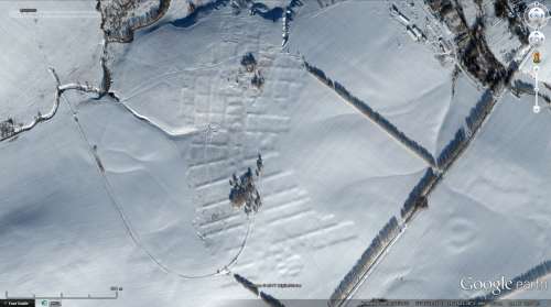
low angle sunlight makes earthwork structure visible on snowy surface, but what was it? it takes place at a hump, not in deep seated area, so the rice-box or fishery concept could be rejected I think. it resembles best to a settlement structure, and good topography just strenghtens this concept. that why and when has it been disappeared, both most important questions after what was it!? parts of the big structure also can be seen by other imagery dates, so as that main part of the area is being cultivated by now. what was here.kmz (899 B) 53°43'53.64"N, 39°29'23.15"E - imagery date: Jan 27, 2013  any infos or ideas? ... (also notice, something like an old, ring shaped earthen fort also can be seen at lower left part of screenshot, and other angular features around placemark) |
|
Master Cartographer
April 2015 - Nov 21, 2024 8:06:11 GMT
|
Post by syzygy on Oct 11, 2017 6:41:46 GMT
I made a folder where I have collected all nearby locations with angular scars and it turned out, that by one exception (my first find) these are related to piles of earth/sand. angular earth scars.kmz (2.14 KB) Probably my first find not, but can these be scenes of earth/sand mining operations? |
|
Full Member
January 2020 - Jan 5, 2024 10:40:59 GMT
|
Post by leong on Jan 18, 2020 9:48:33 GMT
The #### pattern looks like they were just keeping the water in the field. Snow melt otherwise runs off ??
Or they lowed the surface down to the water table ? The presence of those "just dig a hole" water sources nearby suggest that the water issue is common... keeping the snow melt in the #### pattern might help the water table,so that the OOOO water sources keep producing water.
Seems the farmer now just does ordinary drainage and has given up on ####, he is ploughing over.
|
|


