Newbie
December 2016 - Dec 10, 2016 14:05:52 GMT
|
Post by lonious on Dec 10, 2016 14:05:52 GMT
Hey, all!
I was just wondering about the Placemark tool - in particular, its "altitude" option.
I have tried to add a placemark to measure the height of Hunyad Castle in Romania.
The Internet says that this castle rises to 70 meters (230 feet) in height.
However, the very tip of the castle's roof seems to be way below that figure, as I placed the placemark at 80 meters.
How accurate is the placemark's altitude option?
Also, if I mar ask, how accurate is the "Ruler" feature? Can it be used reliably to measure the lengths of buildings?
Thank you very much!
Regards,
Lonious
|
|
Cartographer
April 2015 - Apr 23, 2024 4:32:27 GMT
|
Post by washi on Dec 10, 2016 15:40:02 GMT
The Google Earth Help Forum (link on upper right of this page) is the best place to ask a technical question like yours. The people there are all experienced GE users, are familiar with what has been published about it, and often have access to the Google software engineers. Until you can get an answer from GEHF, here's mine: I investigated your question myself when I first downloaded GEPro and was exploring some of the tools not available before that time to us po' folks. I had previously concluded that the linear measurement tool of a flat measured surface like a football field was surprisingly accurate. My basic conclusion about measuring vertical distance is that 1) it's very hard to do and 2) that it is fairly accurate, but I wouldn't want to use it if I was planning a Men in Black III style leap from the Chrysler Building. That, of course, is the standard caveat about using Google Earth measurements: Never use them to navigate or any other purpose where an error could be hazardous.For this post I added a placemark to the file I posted with a height above ground elevation of 300 meters. It's past my bedtime, and I'm having trouble finding where I posted the original. When I lower the elevation to 298 m, the placemark disappears through the roof. At 299 it's pretty close to right on. Edit:I couldn't find my original post in the new GEC because it wasn't there. I posted it HERE in the old GEC, just a couple of weeks before it was shut down. |
|
Master Guide
March 2015 - Apr 14, 2022 20:01:57 GMT
|
Post by frankmcvey (Angel) on Dec 11, 2016 21:25:30 GMT
Hi, Lonious, and welcome. As far as I can ascertain, Google Earth uses the DTED data, which includes the Shuttle Radar Topography Mission (STRM) data, accurate to better than 30m (around 100ft). This is absolute accuracy, compared to Mean Sea Level. The height data is referenced to a 90m square horizontal grid covering the Earth's surface, so a "spot height" snapshot is taken every 90m. The relative accuracy over a 1 degree area should be better than 12m (around 40ft). Given that 1 minute of arc over the Earth's surface = 1 nautical mile, a 1 degree area covers 60 x 60 = 3600 square nautical miles. It's worth noting that this accuracy is quoted for fairly level terrain. The height accuracy for more steeply sloping terrain goes down to better than 15m. There is anecdotal evidence (such as Washi's) that it can be very accurate in certain areas, but equally, you only have to dive down into the Grand Canyon or another similar area where you have extreme elevation changes in a short horizontal distance (ie cliffs!) to see the inaccuracies - you'll see either rivers or roads painted halfway up canyon walls, for example. Here's a bit of the Grand Canyon: 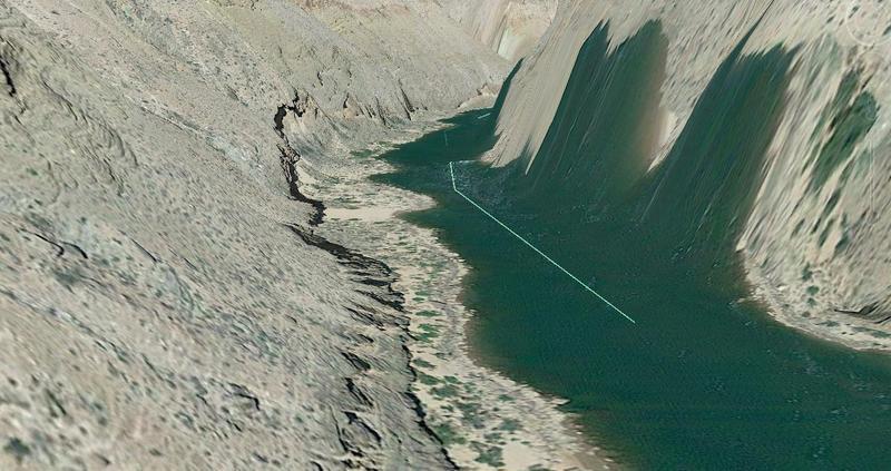 OTOH, the ruler facility is surprisingly accurate. For example, aviation nuts such as myself, when trying to ID an aircraft found on Google Earth, often use the GE ruler to measure the subject's wingspan and length as an aid to ID-ing it. Difficulties can arise, though, when you're looking at aerial photography data, rather than satellite data. If the subject aircraft, for example, is flying only, say, 100 feet below the camera aircraft, it will appear to be absolutely enormous, and will measure as being enormous. However, when measuring objects on the ground, aerial photography data is equally accurate to satellite data, albeit at a much higher resolution in the imagery. The following shows a measurement I took of a Virgin Atlantic Boeing 747 at London Heathrow: 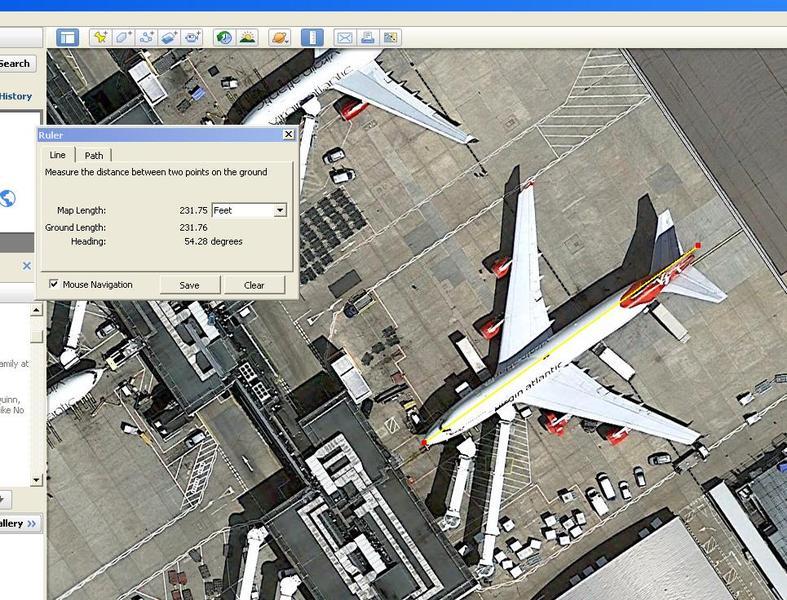 According to Wiki, the length of a 747 is 231ft 10in, so that's accurate to 1"! Mind you, I wouldn't want to say that I'd get it that close every time!  Cheers, Frank |
|
Cartographer
April 2015 - Apr 23, 2024 4:32:27 GMT
|
Post by washi on Dec 12, 2016 1:20:37 GMT
Frank, I suspect the normal imagery and the 3D cities imagery differ greatly in respect to the accuracy of vertical distance accuracy. Google (not surprisingly) seems very closed mouthed about the process of generating the 3D cities imagery, or at least I couldn't learn much about it from my internet search. I suppose, however, that it must be produced by powerful computers grinding away at massive amounts of data, in something like the way the Sketchfab software (apparently, because I've never used it, and am going by what briand said about it) combines large numbers of photographs to produce its models. It seems not unlikely that other kinds of data (radar, for example) might be collected from street view cars as well as aerial photography flights. I think I will stand by my assertion that vertical distance in 3D cities imagery is much more precise than the views of the Colorado River sloshing high onto the walls of the inner canyon. 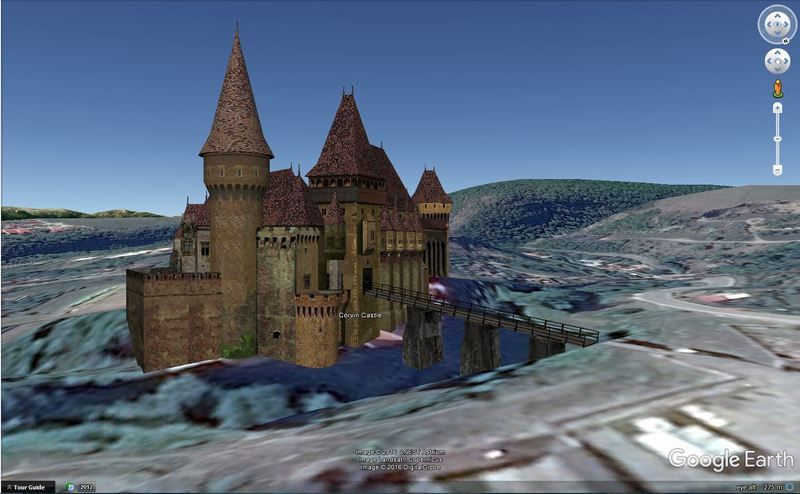 As regards lonious's specific example, the model of Hunyad (Corvin) Castle in Google Earth is handmade. If the modeler was as precise as most modelers are, vertical distance should be pretty accurate. The model appears displayed over the standard 3D imagery, which may or may not be accurate, so any attempts to measure the distance between any point on the building and the ground would be unreliable. Accurate dimensions of a famous structure like that are probably available somewhere, but maybe only tucked away in some library or achieve. Working on the assumption that the modeler had access to it, I might try going to the 3D Warehouse, downloading the model, and using the tools in Sketchup to try to get the measurements I wanted. |
|