Full Member
May 2015 - May 17, 2015 10:07:02 GMT
|
Post by shadowdragon on May 27, 2015 3:46:07 GMT
We have Earth, Mars, the Moon, and a NASA/JPL provided overlay of Mercury, but what about Venus? Venus is the second planet from the Sun, orbiting it every 224.7 Earth days. It has no natural satellite. It is named after the Roman goddess of love and beauty. After the Moon, it is the brightest natural object in the night sky, reaching an apparent magnitude of −4.6, bright enough to cast shadows. Because Venus is an inferior planet from Earth, it never appears to venture far from the Sun: its elongation reaches a maximum of 47.8°. Venus is a terrestrial planet and is sometimes called Earth's "sister planet" because of their similar size, mass, proximity to the Sun and bulk composition. It is radically different from Earth in other respects. It has the densest atmosphere of the four terrestrial planets, consisting of more than 96% carbon dioxide. The atmospheric pressure at the planet's surface is 92 times that of Earth's. With a mean surface temperature of 735 K (462 °C; 863 °F), Venus is by far the hottest planet in the Solar System, even though Mercury is closer to the Sun. en.wikipedia.org/wiki/Venus
I give you the Google Earth Venus overlay.
Venus Megaoverlay.kmz (284.58 KB) It contains:
1 Enhanced Mega Resolution Overlay
B/W Radar with areas of hyper resolution included1 enhanced Super Resolution Overlay:Radar color with areas of even higher resolution included. 7 Super Resolution overlays
Shaded topography Fresnel Reflectivity Meter Scale Slope Microwave Emissivity Left Look Right Look Stereo Look
1 High Resolution Overlay Color Topography 1 low resolution Overlay Free Air Gravity 3 Tiny Resolution Overlays Free Air Gravity Uncertainty Geoid Bouguer Anomaly
And Clouds
Along with:Over 100 located images from NASA's Photojournal. All placenames approved by the IAU with descriptions. Landing and crash sites with descriptions along with pictures from the landers that were able to transmit any. The overlays and images may take a little bit of time to load. 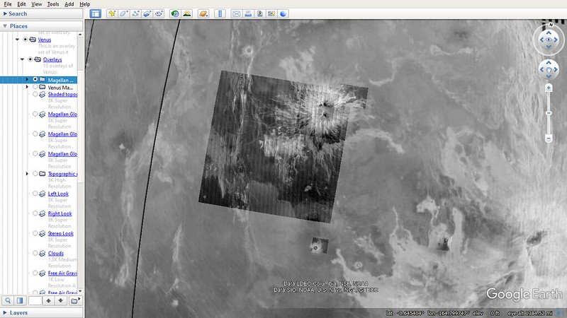 Super Resolution B/W radar map with several dozen areas of hyper resolution peppered in. (This was previously impossible with my old computer) Super Resolution B/W radar map with several dozen areas of hyper resolution peppered in. (This was previously impossible with my old computer) Placenames from the USGS Gazetteer of Planetary Nomenclature. Placenames from the USGS Gazetteer of Planetary Nomenclature. Landers and Crash sites along with images. Cloud layer with Haze (effect caused by layers being "semi-transparent") Over 100 photos from NASA's Photojournal The original overlay was uploaded in 2015 and I was somewhat limited on what could be done back then. I now have a much better computer that allows for 16K resolution overlays. The B/W color overlay is now a 16K image instead of an 8K image when I was previously forced to downsize to. I have also learned a few things like how to add photos, include legends, and draw overlays in order. In 2010 I made a similar series of overlays of all the mapped planets, moons, asteroids and comets except The moon, Mars and Venus. Sadly it was lost in a computer failure that year. |
|
Cartographer
April 2015 - May 10, 2024 6:53:31 GMT
|
Post by washi on May 27, 2015 6:32:15 GMT
What a wonderful piece of work, shadowdragon. It must have taken you hundreds, if not thousands, of hours to research, compile, and present. I find it just amazing that one person could put together a project this expansive and complete!
One thing I should mention: In this post and other that you have made, the graphics that you have inserted are not visible to me. I wonder, are you hosting your images on line before you insert them into your posts?
|
|
Trusted Member
Master Gamer
April 2015 - May 10, 2024 16:21:41 GMT
|
Post by ndrqu on May 27, 2015 10:41:52 GMT
|
|
Master Guide
March 2015 - Jan 20, 2022 4:27:51 GMT
|
Post by Hill on May 27, 2015 22:02:40 GMT
Beautiful and very well done. Lots of choices for maps too.
|
|
Master Guide
March 2015 - Jan 20, 2022 4:27:51 GMT
|
Post by Hill on May 27, 2015 22:15:56 GMT
One thing I should mention: In this post and other that you have made, the graphics that you have inserted are not visible to me. I wonder, are you hosting your images on line before you insert them into your posts? He is hosting his images at photobucket, washi. I wonder why that's a problem? |
|
Full Member
May 2015 - May 17, 2015 10:07:02 GMT
|
Post by shadowdragon on May 27, 2015 22:52:13 GMT
I initially uploaded them through post image which was causing them to not appear. Washi helped me out on it and now I upload them through Photobucket.
I tried to get 3 more maps of slope steepness, surface reflectivity, microwave emissivity, and a slightly higher resolution greyscale version of the radar map but when I tried to enter them in Google Earth, it wouldn't render the entire picture as a layer and only part of it. I am guessing it's because there is a limit to how big of a picture GE can convert to a layer before bugging out.
There is also an around 12500x6000 map in the NASA photojournal site in 2 pieces that would work but unfortunately they are not centered on the established prime meridian of Venus, I didn't want to deal with an offcenter layer and Google Earth still has several bugs associated with the 180 Degree line.
I have updated the overlay with more realistic clouds and a picture comparing the effects to a cloud layer.
|
|
Full Member
May 2015 - May 17, 2015 10:07:02 GMT
|
Post by shadowdragon on May 28, 2015 23:28:57 GMT
What a wonderful piece of work, shadowdragon. It must have taken you hundreds, if not thousands, of hours to research, compile, and present. I find it just amazing that one person could put together a project this expansive and complete! Unlike 2010 where I remember each object taking 12 to 24 hours it only took around 9 hours to complete thanks to the USGS providing KML's for GE showing the location of places on that planet, they probably were waiting for someone to produce an overlay like this and use them in the process. In 2010 I did them manually resulting in it taking a while. The biggest time was spent finding maps to overlay and the permission allowed for them. I have now updated the layer with medium resolution versions of the 3 layers I could not add due to issues with GE adding huge overlays. They were providing smaller versions of the maps. I decided to leave out the medium B/W version of the first map because it would be redundant to add a lower resolution b/w version of what is in color. If your also looking for Venusian terrain, your unfortunately going to have to wait until Google itself makes a globe.  |
|
Full Member
May 2015 - May 17, 2015 10:07:02 GMT
|
Post by shadowdragon on Jun 1, 2015 10:57:44 GMT
I have spent the last few days adding a tour of every image of locations on Venus on NASA's Planetary Photojournal. There is now a series of over 100 located photos to interact with in the overlay showing imagery from the photojournal. photojournal.jpl.nasa.gov/targetFamily/VenusOverall I think this took 15 hours in total. I also changed the name of the layer to avoid confusion with it being put together by Google itself which isn't the case. Next up the other 2 objects in the inner solar system without interactive overlays (besides asteroids and comets), they are small, not round (they will look a little funny as a result), and orbit a red planet. I will probably: skip the asteroid belt for now and do it later in case of further Ceres developments, continue with Jupiter, Saturn, Uranus, Neptune. Depending on time I may do Pluto then loop back to the Asteroid belt and finally add the Sun. When I am done there will be an interactive Google Earth Solar System, much like I tried to do in 2010. |
|
Full Member
May 2015 - May 17, 2015 10:07:02 GMT
|
Post by shadowdragon on Jun 7, 2015 6:25:06 GMT
I have added a medium resolution overlay of free air gravity and low resolution overlays of free air gravity uncertainties, bouguer anomaly, and geoid. I have provided descriptions of what they are but unless your big into geology they will probably appear as just more eye candy to the kmz file.
Meanwhile with the Jovian system, I am currently nearing completion of Io and will work on the icy moons next. Phobos and Deimos are also almost done and I will upload them in a few days.
|
|
Full Member
May 2015 - May 17, 2015 10:07:02 GMT
|
Post by shadowdragon on May 6, 2020 4:01:47 GMT
2020 update, this overlay and other ones are getting an overhaul. Apparently when I made these, I made a lot of mistakes.
I hosted some of the large images on photobucket which eventually desized them and ruined the overlays.
On other overlays, I accidentally hosted the images on my computer and not linking them to the original weblink.
I am now able to make overlays up to 16K in size now which means even more crisp overlays coming in the future.
I learned a few new tricks recently to up the number of possible overlays.
For whatever reason, I never uploaded the Grand Tour overlay. It turns out, I never ended up finishing the assemblage and improvement of it.
Finally, I might try and find a way to host the Grand Tour overlay on a publicly downloadable file so one doesn't have to resort to making an account here. I will still eventually make a post linking to said file though
|
|
Cartographer
April 2015 - May 10, 2024 6:53:31 GMT
|
Post by washi on May 6, 2020 9:53:57 GMT
I remain in awe! Three thoughts after I looked through your very complex file: 1) I found a busted link in the Clouds overly file (http://www.mmedia.is/~bjj/data/venus/venus.jpg), which could well be due to a server temporary down. 2) I think your file would be more manageable if you would close and lock the Venusian Placenames folder. There are so many placemarks in it that with it open, it's difficult to find the other content. 3) I'm really puzzled about where you've tucked away the data that appears when you click on a placemark, if it's not stored in the placemark Description box.
<?xml version="1.0" encoding="UTF-8"?>

<kml xmlns="http://www.opengis.net/kml/2.2" xmlns:gx="http://www.google.com/kml/ext/2.2" xmlns:kml="http://www.opengis.net/kml/2.2" xmlns:atom="http://www.w3.org/2005/Atom">

<Placemark>

	<name>Katieleo Corona</name>

	<ExtendedData>

		<SchemaData schemaUrl="C:/Users/Leroy/Downloads/Venus Megaoverlay.kmz#sql_statement">

			<SimpleData name="Name">Katieleo Corona</SimpleData>

			<SimpleData name="clean_name">Katieleo Corona</SimpleData>

			<SimpleData name="approvaldt">1997/01/01  0:00:00</SimpleData>

			<SimpleData name="origin">Senufo (Burkina Faso) creator goddess.</SimpleData>

			<SimpleData name="diameter">210</SimpleData>

			<SimpleData name="center_lon">327.5</SimpleData>

			<SimpleData name="center_lat">-12.5</SimpleData>

			<SimpleData name="type">Corona, coronae</SimpleData>

			<SimpleData name="code">CR</SimpleData>

			<SimpleData name="approval">Adopted by IAU</SimpleData>

			<SimpleData name="min_lon">327.5</SimpleData>

			<SimpleData name="max_lon">327.5</SimpleData>

			<SimpleData name="min_lat">-12.5</SimpleData>

			<SimpleData name="max_lat">-12.5</SimpleData>

			<SimpleData name="ethnicity">Burkina Faso (Upper Volta)</SimpleData>

			<SimpleData name="continent">Africa</SimpleData>

			<SimpleData name="quad_name">Navka Planitia</SimpleData>

			<SimpleData name="quad_code">v42</SimpleData>

			<SimpleData name="link">http://planetarynames.wr.usgs.gov/Feature/2956</SimpleData>

		</SchemaData>

	</ExtendedData>

	<Point>

		<coordinates>-32.5,-12.5,0</coordinates>

	</Point>

</Placemark>

</kml>
Where does this "extended data" reside, and where can I learn about how to use it? And did you write a tool for generating all these placemarks from some data base?
|
|
Full Member
May 2015 - May 17, 2015 10:07:02 GMT
|
Post by shadowdragon on May 7, 2020 1:16:25 GMT
The placenames were downloaded directly from the USGS/IAU Gazetteer of Planetary Nomenclature. They provide kmz files of all objects with names landmarks. When downloaded, they fit right into place with their spot on the maps (though some maps have to be rotated 180 degrees). planetarynames.wr.usgs.gov/UPDATE: Moon and Mars are getting overlays in this too. I'll discuss it more in the relevant forum when I finish those but speaking of placenames, they will include updated names of those 2 places since hundreds of names have been added by the IAU (and google won't update them anymore) Thanks for the suggestion to lock the folders and I am happy to hear these addon's still amaze many (even if the old version has gotten rusty from expired image links and photobucket resizes). |
|
Full Member
May 2015 - May 17, 2015 10:07:02 GMT
|
Post by shadowdragon on May 11, 2020 2:16:52 GMT
Update: It won't be long before I have the improved Venus Megaoverlay ready for release in a week or so. I have hit a problem however where attempting to load the main overlay with insets of more detailed regions temporarily freezes the computer for a couple minutes due to memory shortage. The working solution so far has been to open the overlay in GE without any other programs running, then turn on nomenclature.
|
|
Cartographer
April 2015 - May 10, 2024 6:53:31 GMT
|
Post by washi on May 11, 2020 5:12:45 GMT
Update: It won't be long before I have the improved Venus Megaoverlay ready for release in a week or so. I have hit a problem however where attempting to load the main overlay with insets of more detailed regions temporarily freezes the computer for a couple minutes due to memory shortage. The working solution so far has been to open the overlay in GE without any other programs running, then turn on nomenclature. Have you assigned a higher Draw Order to the second overlay? (It's under the Altitude tab.) Have you considered loading the second overlay from within the main file? |
|
Full Member
May 2015 - May 17, 2015 10:07:02 GMT
|
Post by shadowdragon on May 12, 2020 7:23:06 GMT
Yes the draw order is done so the detailed areas always show on top of the base overlay.
Loading the second overlay from the main file? Could you elaborate what that means please?
|
|
Full Member
May 2015 - May 17, 2015 10:07:02 GMT
|
Post by shadowdragon on May 24, 2020 22:00:26 GMT
NEW 2020 edition of the overlay is up. It has updated placenames, a higher resolution B/W radar map, several dozen select areas of higher resolution, and improved information about landers.
|
|
Full Member
May 2015 - May 17, 2015 10:07:02 GMT
|
Post by shadowdragon on May 28, 2020 7:50:02 GMT
UPDATE: I found a 18K version of the B/W radar imagery. While I had to downsize it to 16K (after 20 minutes of converting file type and doing so) It is twice the resolution of the 2015 upload now.
|
|


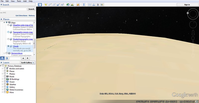 Cloud layer with Haze (effect caused by layers being "semi-transparent")


