Post by washi on Apr 17, 2015 16:12:38 GMT
This post is intended to be an extension of my post Overlay Maps of Japan's 8th Century Capitals . (You may wish to download it and enable the folder called “Heian Kyō” as context for this presentation.
Japanese is written with no spaces between words. For the benefit of English readers, I have followed the convention employed in the parent post of breaking what would be thought of as one word by Japanese readers as two or more words, breaking it where the break would come if the equivalent meaning were expressed in English.
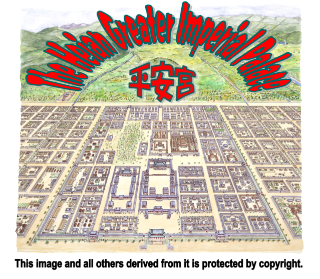
This area was the location of Japan’s central government from 794 until its last vestiges were destroyed by fire in 1227, although the actual governance of Japan passed to the Kamakura Shogunate in 1185, and the real focus of political power was often in the hands of regents or retired emperors who lived and ruled from outside of this area throughout the Heian Period. Following the abandonment of this site, the area was built over and rebuilt countless times throughout the centuries. The modern city that exists over it has afforded few opportunities for archeological investigation, but the extensive records (written documents, maps, and pictures) has allowed the Greater Palace site to be mapped with a fair degree of accuracy. I have taken some pains to present it here because the last of the 8th century capitals represents the fullest development of the Ritsuryō or Statutory system of government which reached its apex in the 8th century, and of which all of the capitals presented in the parent post are an expression. Indeed, it was only a few decade after the founding of Heian Kyō that the Ritsuryō system began to implode, but it seems doubtful that as the 8th century drew to a close, many people (certainly not the Emperor Kammu who moved it to this site) thought that such a complex and elaborately conceived system of government could unravel so quickly. Some of the places explored in this post date from a later period, and it is necessary from time to time to speak of times and conditions removed, sometimes far removed, from the capital’s late 8th century founding, but for the most part, an investigation of the sites in the Heian Palace is also an investigation of the system of government that prevailed in Japan for nearly two centuries.
Although I have worked for many months on this project, it still falls short of what I had hoped (and still hope) it would become. There are still many locations about which I have uncertainties and further questions, and I fear there may still be errors in some of the place names and my attempts to romanize their pronunciation. (Japanese has a very complex writing system, and even an educated person is frequently at a loss as to how to pronounce an unfamiliar place or personal name. Popular publications limit the use of kanji (the Chinese derived characters) to about 2000 of the perhaps 50,000 or more that exist, but even then it is typical for one character to be pronounced in multiple ways: At least one of them is usually the result of forcing the Chinese pronunciation into the Japanese sound system, and multiple “Chinese” readings exist if Chinese loan words entered Japanese at different periods in history, when spoken Chinese itself was not the same. These problems are compounded by the fact that the kanji came to be used to write native Japanese words, greatly increasing the number of possible readings. Imagine, for example, that the Latin word “caninus” was written with the symbol 犬, but that character could be read as “canine,” “dog,” “hound,” and even “mutt,” or “pooch,” and you get some idea of the scope of the problem. Add to that, the degree to which the Japanese language has evolved since the end of the 8th century, and you will perhaps understand my frustration, although in fairness, in all of the sources I consulted, I encountered no archaic kanji, which suggests that these writers had at least relieved me of that burden.
I would, of course, be grateful for feedback concerning these matters, other errors, or suggestions to improve the post.
I need to acknowledge my debt to several individuals in preparing this post. The first is GEC member HRNA, who has placemarked 3 important sites relevant to this post, The Daigoku Den, or Great Hall of State, The Suzaku Mon, or Grand Entry Gate to the Daidairi, and The Dairi, or Imperial Residential Compound. I made extensive use of the Wikipedia articles Heian Palace and Ritsuryō, as well as “The Capital and Its Society,” by William H. McCollough. This is Chapter 2 in Heian Japan , Volume 2 of The Cambridge History of Japan . I would like to thank Mr. Takashi Nakagawa and Ms. Junko Tamaru of Kyoto ASUNI (Athenaeum) for securing permission for me to use selected portions of their copyrighted materials, and for providing me an introduction to Mr. Toshio Kajikawa, who graciously consented to allow me to use his wonderful illustration of the Greater Palace area. Mr. Kajikawa is the section manager of an agency within the Kyoto city government charged with the preservation of its cultural heritage. His keen personal as well as professional interest in the palace site is evidenced by the careful research evidenced in his drawing. He is not a professional illustrator, but his artistic skills are apparent not only from his splendid painting, but also in the letter he sent me, not the easiest to read perhaps, but certainly the most beautiful I have ever received. Without either of these permissions, this effort would have been greatly diminished. I would like to thank Mr. Shigekazu Nagamune, the director of what is called in English the Kyoto City Archeological Research Institute and its attendant Museum for answering numerous questions and for giving permission to use materials in the recent publication 紫式部生きた京都 (つちの中から) :::: Murasaki Shikibu Ikita Kyōto (Tsuchi no Naka Kara), which in English might be something like The Kyoto in Which Murasaki Shikibu Lived (From Under the Earth), as well as Mr. Kengo Miyahara, an expert in the mapping of archeological sites on his staff. I need also to thank my friend Mr. Mineo Kimbara for translating correspondence and other documents into Japanese.
Mr. Kondō, dressed as a Heian Period nobleman, at a recent ASUNI function. (If he were a Heian Period noble, his name would likely have been pronounced as “Chikafuji no Mitsunari”).
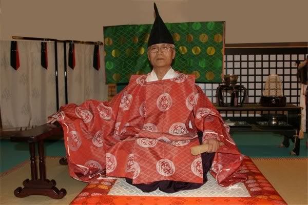
Finally, I need to acknowledge Mr. Mitsunari Kondō, who has been a partner is producing this post. Mr. Kondō serves one day a week as a volunteer guide at the superb Heian Kyō model, and I met him by a great stroke of luck at the site were I had been disappointed to learn that the model was no longer housed. He guided me across town, secured permission for me to photograph the model on two occasions, met with me on numerous subsequent occasions to introduce me to the ASUNI and KCARI staffs, showed me various locations, and even traveled to my home so we could see the post as it was being written. His assistance in doing research and facilitating access to the people to whom I needed to speak has been invaluable.
This post contains several techniques which may be of interest to GEC members with no particular interest in Japanese history. The photo overlay has been available for some time, but I have seldom seen it employed in what seems to me to be its greatest potential: to help visualize structures that are no longer present. It becomes more interesting if one zooms in on the image and moves around in it, using the opacity slider to fade it in and out to compare the image with what lies behind it. There are numerous example of the OFT link made possible by KEYHOLE 2.2, whereby a balloon from another placemark, folder, or path is opened from a link within a placemark, and in some cases flown to. There is one example of a DOFT link, whereby a placemark is downloaded from another post and then opened and flown to.
Absolute accuracy in the location of Google Earth imagery is not possible, at least in the foreseeable future. The angles from which satellite images are taken and other factors cause the apparent position of the objects viewed to shift in unpredictable ways each time the imagery for an area is updated. The imagery used to create the rather precise placement of overlays and placemarks is based on the imagery dated March 31, 2007. Clicking the Historical Imagery icon (the clock) should realign any updated imagery to the positions used in this file. If it doesn't, please select that date.
The copyrighted images used in this presentation and others derived from them are used with permission. You should infer no permission to reproduce them for anything other than personal use. This means you have NO permission to reproduce them in any publication, printed or digital. If you wish to secure such permission, please write to me by PM or email, and I will provide you with the contact information.
You will need to make sure 3D Buildings in the Layers is turned off, and otherwise follow the directions on the screen as it is loaded.