Cartographer
April 2015 - Apr 23, 2024 4:32:27 GMT
|
Post by washi on Apr 14, 2015 8:13:47 GMT
I recently replied to a post in the History Illustrated forum which displayed a path showing a possible route of the Carthaginian general as he crossed the Alps in the autumn of 218 BC. I was highly skeptical of this suggested route, primarily because, after examining it closely, I concluded that the pass through which it traveled seemed far too high and difficult for even foot soldiers to traverse, let alone cavalry and elephants. I hadn't thought much about the event since my high school days, when the exploits of Hannibal were far more interesting (and a great deal more comprehensible) than the Latin pluperfect subjunctive, so I set out to explore what the other choices might be. I'm certain that many people know more about this topic than I do, I, who have not read any of the numerous historical writers who have addressed it and have never been in the area, so I welcome comments regarding anything I have misunderstood and misrepresentations I have made.
When my Japanese wife asked me what I was doing, I explained that I was trying to determine where Hannibal had crossed the Alps. We both had a good laugh when I discovered the only Hannibal she knew was that frightening creation of Anthony Hopkins. This next paragraph is for her, and if you already have some basic knowledge about the Second Punic War, I suggest you skip it. (To give my wife her due, she did know what I was talking about when I pronounce the name in Japanese: "Han ni ba ru".)
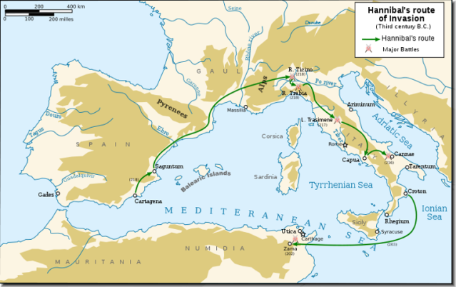
In the days of the Roman republic, Rome's greatest military rival was Carthage, a city state of Phoenician people located on the North African coast of the Mediterranean Sea, near the modern city of Tunis. Rome and Carthage fought three great wars between 264 BC and 146 BC. Hannibal was the second son of the Carthaginian commander in the first war. Following the death of his older brother, he assumed command of the army and revived his brother's plan to enter the Po River Valley in northern Italy and ally himself with the enemies of Rome who resided there. He led his army from Iberia (now Spain) across the Pyrenees through Gaul (now France), where he accomplished a difficult crossing of the Rhone River, and across the Alps. He allied himself with several of the non-Roman peoples in Italy, won a number of famous battles, and generally made life miserable for the Romans for 15 years, when a Roman counter attack forced him to return to Carthage, and where he was defeated.
In my search for just where the crossing of the Alps occurred, I encountered one splendid site, Livius.org, which is extensive, well documented and scholarly. I have read none of the primary documents referred to myself, and have relied heavily on that site as my source of information. The site was created by Jona Lendering, and the page of that site that I used is called "Hannibal in the Alps". Lendering, in turn, credits Peter Connolly in his book Hannibal and the Enemies of Rome (1978 London) as the originator of the arguments advanced. There is little likelihood that I could locate this book in a library here in Japan and there is nothing in my high-yen battered dollar income to buy a copy, even if I had sufficient gumption to read it. Much of the material I have adopted here for viewing in Google Earth is theirs, and when I refer to Lendering I am referring to both. When I have ventured an observation of my own, I have clearly labeled it as such, and otherwise anything else is not. I have tried to be faithful to their work, and if I have failed to do so, I apologize. The writings of the various historians and historical figures cited in the placemarks as advocates of one pass or another are unfamiliar to me, and for the most part I have been unable to even find out who they are. I have lifted the names from Lendering, and have done so to give weight to the assertion that a consensus never has and still does not exist.
(I did find one other significant discussion on the internet, an article published in Mediterranean Archaeology and Archaeometry, ponderously titled "Hannibal's Trek Across the Alps: Geomophological Analysis of Sites of Geoarchaeological Interest". I found most of the evidence examined in this article inconclusive and the arguments not particularly persuasive, but reading it left me with two impressions. First, the debate that has continued for centuries about Hannibal's route is by no means settled, and second, which route a person favors depends very much on how the apparent contradictions in the historical documents are resolved in regard to that particular route. The article is referred to in the post as "Geomorphological Analysis".) Another site of interest is Hannibal in the Alps: Stanford Alpine Archaeology Project 1994-2006.
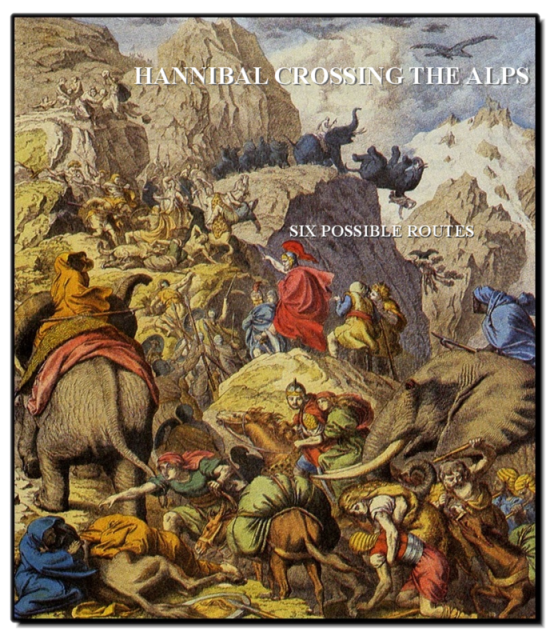
No one knows which pass Hannibal's Celtic allies guided him through. Lendering lists six possibilities, each with a string of historians and historical figures who have advocated for it: (listed from north to south) Col du Petit Saint Bernard, Mont Cenis, Col du Clapier, Col du Montgenèvre, Col de la Croix, and Col de la Traversette.
Two ancient historians wrote detailed accounts of the transit. Polybius of Megalopolis (ca. 200–118 BCE), who was in his youth a respected hostage in Rome, wrote a book called Histories, which covered the entire period of the Punic Wars. (It was Polybius whose thinking about the concept of divided political power influenced the writers of the U. S. Constitution.) Titus Livius (59 BC – AD 17), better known to we English speakers as Livy, wrote a monumental work called The History of Rome from its Foundation, and he describes the crossing in the twenty-first book of that work. Polybius was alive at the time of the event and writes that he had spoken with people who had made the trip and visited the area himself. Livy was born a century and a half after the event. Polybius was the main source for his account, but both authors are thought to have used an account, likely written by a Carthaginian who had made journey, but which is now lost. Livy may have known this lost work though another work based on it. It is Livy who provides the time-line of events, and Lendering gives equal weight to Livy's version because of his practice of careful copying of details from source materials. The Polybius translation by Ian Scott-Kilvert that Lendering uses may be found HERE (paragraphs 50 - 56). I couldn't find the Aubrey de Sélincourt translation of Livy he used on-line, but another translation may be found HERE (BOOK XXI, paragraphs 31 - 33).
After a difficult crossing of the Rhône River at a large island whose location seems to be agreed upon, Hannibal led his army into the foothills of the Alps. (Just where he entered the foothills is not known, but if it were known, some of his possible routes could be eliminated. If you noticed Polybius' reference to a march up the Isère River, please also see the footnote that explains that the original does not name the river. Whichever way he proceeded, it was no doubt in a direction to evade the Roman army lead by Publius Cornelius, which marched on the deserted crossing site camp in battle formation just 3 days after the crossing). Livy says it took him 15 days to march from the foothills of the French Alps to the level of the Po River plain in Italy. So long as he remained in open country, the hostile native forces avoided confrontation. But after the rear guard of friendly natives troops dropped off and he began to negotiate narrow passages in the mountain valleys and passes he was attacked several times by hostile natives. In these bloody encounters as well as in frequent accidents caused by the rugged terrain, he suffered heavy losses, not only of his troops, but also to his baggage train and now-famous elephants and other animals. His army camped for 3 nights in the pass. While they were there, snow began, complicating the difficult decent over steep terrain. Even in Livy's time, the size of his force was reported in widely differing numbers, but the lowest estimate of the size of the army that arrived in Italy was 20,000 foot and 6000 cavalry. The authors of "Geomorphological Analysis" give a further estimate of 10,000 pack animals and a like number of handlers.
IMAGES USED IN THIS POST ARE ALL IN THE PUBLIC DOMAIN. IN THE FILE YOU MAY CLICK ON IMAGES FOR SOURCE / LICENSE INFORMATION.
The file attached below contains a network link file for downloading Part Two. Part Two includes an extended version of this introduction, rough paths and tours of each route with pro and con arguments for each, and a set of placemarks showing Lendering's (and probably Connolly's) interpretation of where the various incidents occurred.
 Download File Download File
Post last revised March 13, 2023.
|
|
Newbie
April 2015 - May 4, 2015 14:39:37 GMT
|
Post by robur2 on May 1, 2015 18:44:30 GMT
Bonjour, My apologies for the corrections made . «SIX POSSIBLE ROUTES» do not take into account the reality of the state of knowledge of the Alps in this time (218 BC). According to Polybius himself (as quoted by Strabon) there were in his time (2nd century BC) only four alpine passes : from north to south, a pass leading to the Raethians (Switzerland, Tyrol), a pass leading to the Salassi (Val d'aoste : col du Petit Saint Bernard), a pass leading to the Taurini (col de Montgenèvre), a pass leading to the Ligurians (col de Tende). The fact is not contested by historians. In the time of Strabon (1st century BC), a new pass was opened, accessible only for foot travelers (col du Grand Saint Bernard). As the result : Col du Mont-Cenis, Col du Clapier, Col de la Croix, Col de la Traversette. and others (col de Malaure, col de Larche, col de Mary....) were not known in the time of the second punic war. In the case of Hannibal's route, extremes passes must be eliminated (leading to the Rhaetians and leading to the Ligurians). The two remaining passes are the col du Petit saint Bernard leading to the Salassi, from northern alpine valleys and the col de Montgenèvre leading to the Taurini from southern alpine valleys, col de Montgenèvre. First route through northern alpine valleys seems to be in line with Polybius's route, going up the Rhone. Second route trough southern alpine valleys seems to be in line with Livy's route through southern alpine valleys going up the Durance. However, before we go any further, let us not forget that ten years later, a second Carthaginian army used a very différent (and still unknown) trail to cross over the Alps. Indeed Hasdrubal, Hannibal's younger brother leaded a reinforcement army which was twice as large and included twenty elephants. What is needed, therefore, to resolve the problem of these two possibles passes, is to figure out just which path Hasdrubal followed. Otherwise Hannibal'route will remain doubtful (and contreversial). If even we can find the path followed by Hasdrubal,we are not out of the woods , because both Polybius and Livy, our reference historians, used accounts from scolars such as Silenos and Sosylos who travelled with Hannibal and scholars who did not know the geography of the areas the Carthaginian army went trough. So our two authors did not know more than these scolars and each of them separately, in their own way, from these sources, for the purpose of their «Histories», drew a different route for Hannibal. To be seen Hannibal et la traversée des Hautes-alpes, la fin du dogme. Good evening from Rambaud Hautes-Alpes (near Gap). hannibal-hautes-alpes.fr.pnhannibalhautesalpes.wordpress.com E-mail rambelaid arobase gmail.com |
|
Cartographer
April 2015 - Apr 23, 2024 4:32:27 GMT
|
Post by washi on May 2, 2015 3:17:49 GMT
Hi robur2,
Thank you for waiting until I got finished with most of what I wanted to accomplish before the old Google Earth Community was closed. I'm very pleased that you have replied to this post. As I said at the outset, I've never been to these places, have never read any of the books which advocate the various routes, have absolutely no expert knowledge, and only claimed from the beginning of my project until I finished it, a sense of curiosity about the subject, which I did everything I could with the very limited resources available to me to satisfy. I always hoped, and said as much in the post, that someone who knew more than I do would reply. You obviously are such a person. I am only sorry that your reply came too late to get your point of view expressed in the GEC Layer, where it would have had a much wider potential audience.
As a foreigner living in Japan, communicating across a language barrier is fact of daily life for me. I can negotiate most of the necessary tasks of daily life (order a glass of beer and ask where the toilet is), read signs and the captions on maps and pictures, but when it comes to understanding fine distinctions in meaning, I might as well be blind and deaf.
As I understand what you have written in English:
- Only two of the six passes are viable possibilities, col du Petit saint Bernard and col de Montgenèvre.
- You have identified a third route, base of the writings of scholars who traveled with Hannibal and who themselves were sources for both Polybius and Livy, and have explained in your book why you find this route more plausible.
Perhaps one of the French speaking members would be willing to read what you have linked to, and advise me if I have misunderstood.
It you would like to make a post of your own (that is a KMZ file illustrating your ideas of the subject), I would be happy to do whatever I can to assist you.
Sincerest thanks,
washi
|
|
Newbie
April 2015 - May 4, 2015 14:39:37 GMT
|
Post by robur2 on May 3, 2015 18:39:14 GMT
Bonjour,
My apologies for my bad english:
Quote
"Only two of the six passes are viable possibilities, col du Petit saint Bernard and col de Montgenèvre.
"
In fact, searching about these two viable possibilities, I have identified (IMHO) the third route never factored : id est Hasdrubal's route and that route appears to be one of the only two viable possibilities !
I therefore have worked on the remaining viable possibility from the writings of scholars [who travelled with Hannibal's army and were sources for both Polybius and Livy] by isolating its
from the accounts of our both historians and removing the personal assessments, additions and interpreations of our two authors.
That was the basis I used for my analyses and for the beginning of my thinking.
The inquiry revealed that these scholars were not at the same place in Hannibal's army progress.
One located at the frontguard and near Hannibal and source of Livy, the other located at the rearguard and source of Polybius.
All this way may well explain the différent perspectives présented during the events by Polybius and Livy and concerning Hannibal.
Indeed, our scholars provide geographic and topographic detail only when Hannibal must be doing something significant :where and when Hannibal has its part to play in this story, in the areas of first and second ambush in our case
So our scholars remain silent on alpine entry and exit of the Hannibal's army (nothing signifiant with Hannibal at this time)
Thus there is a gaping hole in the writing of scholars and in the accounts of Polybius and Livius about the alpine entry.
Both historians drew a different route for Hannibal :Poybius after deciding to go have a look as he said, Livy using Timagene's writings without saying it.
Both historians remain silent on the area of the alpine exit despite a long text describing a apocalyptic [under different circumstances !] descent of undeads on the italian side.
One clear trend to emerge is that our reference authors in the case of the crossing of the Alps knew nothing about the location during this period.
In the Hannibal crossing the Alps Polybius have misreprensented the lines of scholars by cutting in and adding others of his own for his Greek readers .
In the Hannibal crossing the Alps Livy reported the lines from scholars word for word and his account should be seen as more likely of the two and taken as reference [provided that their translation is proved].
These are some data of the question .
To be seen Hannibal et la traversée des Hautes-alpes, la fin du dogme
(Hannibal and the crossing of Hautes-Alpes, the end of the dogma]
hannibal-hautes-alpes.fr.pn
hannibalhautesalpes.wordpress.com
E-mail rambelaid arobase gmail.com
|
|
Cartographer
April 2015 - Apr 23, 2024 4:32:27 GMT
|
Post by washi on May 4, 2015 6:22:07 GMT
Hi robur2,
I'm sorry to be slow in answering your reply. I've been busy doing other things that have kept me away from this site. Thank you for your answer. Your ideas seem quite interesting to me, although I am not qualified to evaluate them. I suggest you create a path showing what you think to be Hannibal's route.
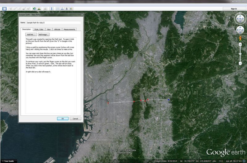
Making a path is not difficult. I have written directions for making one in this picture. The say:
It sounds complicated, but it's very easy. Make a few simple practice paths, like how to get from you home to you favorite restaurant, etc.
We should communicate in some other way. I would prefer to use the message tool here. Any place you see my user name (like this post or my Profile) click the ˅ next to the gear tool icon upper right, select "Membre" and then "Envoyer un message."

You should edit your previous posts and remove your email address, even though it doesn't work. Rule 3 requires that we not post email address or other private information.
I hope to hear from you soon.
Regards,
washi
|
|
Newbie
April 2015 - May 4, 2015 14:39:37 GMT
|
Post by robur2 on May 4, 2015 11:58:24 GMT
Bonjour,
Quote «I suggest you create a path showing what you think to be Hannibal's route. »
I don't agreed to make a path (even if it would not be difficult with Google earth) as it cannot show what I think to be Hannibal 's route because I have to write hundred pages to explain my thinking on this.
Hannibal crossed the Alps in 218 BC, and I did not know the trick to get maps, photographs, drawings on the state of the Alps more than 23 centuries ago, so my book contains none and it seems that Polybius Livy and others had the same problem in their time .
Since 2233 years many things have changed in the alpine valleys, some mountain ranges have seen a considérable erosion, used trails are lost, valleys swamps have been drained, marshes vanished, villages were displaced, and there are now lakes, damps and others water storages......and so on.
Google earth is not a time machine,I used google earth to get an overwiew as one factor among many others to have an opinion.
My book is a sum of reflections, from the anciens texts, allowing to see what comes with its.
From that perspective making a path is too far simplistic compared to what had already been achieved,
Please tell me well why I should have to edit my previous posts and wher.e
Salutations depuis Rambaud (Hautes-Alpes, High Alps County)
To be seen Hannibal et la traversée des Hautes-alpes, la fin du dogme.
(Hannibal and the crossing of Hautes-Alpes, the end of the dogma]
hannibal-hautes-alpes.fr.pn
hannibalhautesalpes.wordpress.com
|
|
Cartographer
April 2015 - Apr 23, 2024 4:32:27 GMT
|
Post by washi on May 4, 2015 14:17:31 GMT
I am sorry. I still do not understand your basic idea, and I thought if you would be willing to draw a simple path I might. The rules for this forum (including rule 3) are found HERE. Unless I can understand your basic idea, it is hopeless for me to evaluate any of your supporting statements. I must excuse myself from this conversation. If your book is ever translated into English, I might try to read it, but until then my interest in it is at an end. Thank you for your interest in my attempt to explore the complex subject. washi |
|


