Full Member
Cartographer
May 2015 - Oct 6, 2022 0:44:12 GMT
“ Fellow Royal Canadian Geographical Society „
|
Post by jeanthie on Jun 14, 2015 18:44:10 GMT
In 2007 I started two beaver related threads on the Google Earth Community Forum: Some of the highlights from the previous threads: The images below provide visual examples of each of these highlights, further described in the original post and on my website. 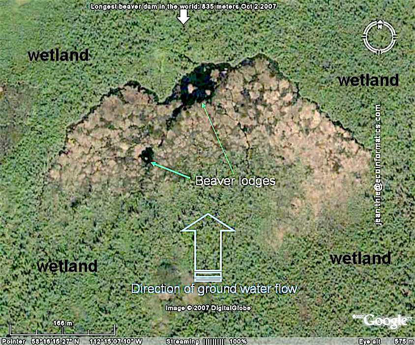 The longest beaver dam in Europe???... Karelia 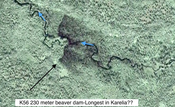 incredible density of beaver dams in Saskatchewan, Canada 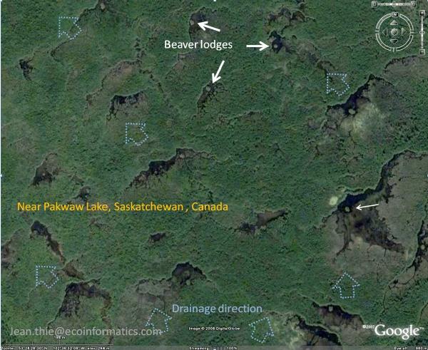 The GE image above represents the white square below on the NASA World Wind Pseudo Colour Images (2000). The beaver ponds are clearly visible as dark bleu spots. I have delineated a number of areas in red showing comparable densities and patterns.  This thread will continue with some of the many surprising and analysis enabled through the unique access provided by Google Earth to an amazing global coverage of satellite and airborne images throughout the world. This thread will continue with some of the many surprising and analysis enabled through the unique access provided by Google Earth to an amazing global coverage of satellite and airborne images throughout the world.Jean Thie |
|
Full Member
Cartographer
May 2015 - Oct 6, 2022 0:44:12 GMT
“ Fellow Royal Canadian Geographical Society „
|
Post by jeanthie on Jun 23, 2015 0:11:35 GMT
Exceptional Beaver Habitat: Beaver Bay 'Beaver Landscape' in MinnesotaWhile reading " Exploring the fur trades routes of North America" by Barbara Huck et al., I used Google Earth to study the Fur trade canoe routes and survey the surrounding areas for exceptional beaver habitat. On my surveys of the satellite images just South of the Grand Portage, I discovered a rather imposing beaver landscape in Minnesota, near Lake Superior, which reminded me of the high density beaver landscape I described earlier near High Level, Alberta Canada. Perhaps not surprising part of this extensive beaver landscape drains through the Beaver River into Beaver Bay. The early voyageurs and settlers certainly gave the perfect geographical names to Beaver Bay Village, and Beaver Bay where the Beaver River drains into Lake Superior. I have defined 'Beaver Landscape' as an area of land and water, where virtually all drainage ways and flows (except rivers and major streams) are controlled ('managed') by beavers.With the following satellite images I would like to illustrate this exceptional beaver domain. Below: The Beaver landscape with a large number of beaver systems managing specific drainage flows  The relief and drainage map below shows the approximate location of the beaver landscape. The drainage pattern shows the parallel drainage pattern typical of this beaver landscape.  Below: NASA World Wind pseudo colour image from the 2000 coverage. The sequence of small black-blue 'dots' are beaver ponds in series controlling the water/ drainage flows with many dams. See for example near the white arrows  Below: Shows the 'beaver system' at the end of the top arrow of the above image. The dams and beaver meadows can easily be seen. ![]()  Close to the beaver system above are these classic dams. beaver lodges can easily be seen with this very high resolution satellite image. The right dam is close to 200 meters in length.  beaver_bay_beaver_landscape.kmz beaver_bay_beaver_landscape.kmz (6.39 KB)
|
|
March 2015 - May 1, 2023 4:20:37 GMT
|
Post by diane9247 on Jun 26, 2015 6:31:04 GMT
Bonjour, Jean! Good to see you and this great post here.
|
|
Full Member
Cartographer
May 2015 - Oct 6, 2022 0:44:12 GMT
“ Fellow Royal Canadian Geographical Society „
|
Post by jeanthie on Jun 29, 2015 0:25:33 GMT
Beavers at their Northern Limit
York Factory in the Hudson bay Lowlands of Canada, at the mouth of the Hayes River, was one of the most important trading posts in North America. York Factory was the Headquarters of the Hudson's Bay Company.  Beaver pelts formed an important part of the fur trade. Most of the beaver in the surrounding area of York Factory were likely soon trapped into 'extinction' after the trading post was established. The huge amount of pelts trading through this post were carried by canoe and York boat through an extensive network of rivers, portages and trading posts, ultimately stretching to the Rocky Mountains. I thought that it would be interesting to take a look at the present 'state of the beaver' and its distribution in this area. Amazing high resolution imagery is available through Google Earth and allows the mapping of virtually every existing beaver dam. I did not attempt to do this, but the selection of beaver dam sites from this GE-Post, provides enough of a base to conclude that this area is rather poor habitat for beaver.  A typical beaver dam, located close to the tidal flats of the Hudson Bay, in a small creek, which flows through permafrost peat plateaus (dark treed-Spruce areas). The area around the Hudson Bay is affected by isostatic or post glacial rebound of about 1 cm per year, after the retreat of the last ice sheet. The beaver dam on the image below makes use of one of the old beach lines.  This image is just upstream from the one above, slightly larger scale. The white arrows point to very small dams. The dark green areas are permafrost peat plateaus covered with Black Spruce and lichen. Tree shadows are long because of the low sun angle. Light green coloured thermokarst wetlands are quite prominent.  beavers_york_factory_area_2.kmz beavers_york_factory_area_2.kmz (11.61 KB)
|
|
Full Member
Cartographer
May 2015 - Oct 6, 2022 0:44:12 GMT
“ Fellow Royal Canadian Geographical Society „
|
Post by jeanthie on Jul 3, 2015 18:11:34 GMT
High Resolution Satellite in Beavers ParadiseThe present abundance of high-resolution satellite imagery remote parts of the world opens up new dimensions in understanding amazing landscapes with Google Earth. This is the case of Tierra del Fuego. An amazing area because of its location, mountains and wetlands and …..its exploding beaver presence. In 1945-1946, Tom Lamb of Lamb Air was asked to provide and deliver 50 Manitoba beavers to the small community of Ushuaia in Argentine. He collected the beavers in Northern Manitoba and released them near Fagnano Lake at the mouth of the Claro River. The goal of the introduction was to promote a fur industry. The beaver population has grown and expanded exponentially and geographically: present estimates more than 100’000! ![]() 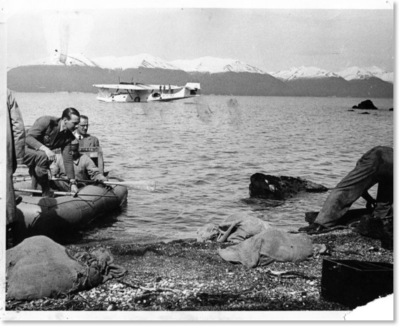 ![]() This expansion has been described and mapped by C.B. Anderson, Source: C.B. Anderson, 'Invaders in an Invasible Land', Principles of Conservation Biology 3rd Edition (2006) pp. 321-323  ![]() The Abstract of Andersons 2009 paper provides a succinct overview of the status of the beaver in this area. Correspondence: C. B. Anderson E-mail: canderson@alumni.unc.edu Mammal Rev. 2009, Volume 39, No. 1, 33–52. Printed in Singapore. © 2008 The Authors. Journal compilation © 2008 Mammal Society, Mammal Review, 39, 33–52 Keywords: Castor canadensis, ecosystem engineer, exotic, invasion, Nothofagus, Patagonia. This post reviews the area affected by the first decades of beaver expansion: 1945-50s; 1950-1960s. Future posts will explore the 1970s, 1980s, 1990s and 2000 and later. The purple markers show beaver systems in area invaded between 1945-1950. The red markers show the expansion between 1950-1960.  Some examples of the impressive beaver dams, and landscapes are given below and many more in the attached KMZ file  The image below shows the series of beaver dams on both sides of the wetland close to the riparian forest where food is most abundant. The wetlands in the centre are bogs with abundance of sphagnum.  Typical example of a stream managed by beaver.  Tierra-del-fuego-beaver-1945-1960.kmz Tierra-del-fuego-beaver-1945-1960.kmz (410.8 KB) |
|
Full Member
Cartographer
May 2015 - Oct 6, 2022 0:44:12 GMT
“ Fellow Royal Canadian Geographical Society „
|
Post by jeanthie on Jul 6, 2015 2:18:09 GMT
Tierra del Fuego: Expanding Beaver Area between 1960 and 1970The pervious post 'mapped' the incredible expansion of the beaver population in Tierra de Fuego. The 'castor canadensis' originating from the Saskatchewan River Delta close to the community of Moose lake in Northern Manitoba, Canada thrived in the fascinating area of Tierra del Fuego. The attached KMZ provides 35 plus place marks giving a representative overview of the expansion area between 1960 and 1970. It is actually quite amazing to see the distances they migrated in this short period of time. The selection of place marks is based on the map provided by C.B. Anderson, included in the previous post. Source: C.B. Anderson, 'Invaders in an Invasible Land', Principles of Conservation Biology 3rd Edition (2006) pp. 321-323 Beaver expansion place marks 1960-1970 Some examples of the beaver systems in this selection: A beautiful example of a high density beaver area associated with the impressive wetlands of Tierra del Fuego.  The image below shows a series of beaver dams in an areas that was burend over not too long ago. You can see the dead trees on the high resolution images in the grey areas. Not beaver kill in this case  The image below is in a similar landscape as the beaver system above, but not burned by a wild fire. Trees killed by beaver can clearly be seen.  This mountain slope is being logged by beaver, using beaver streams a 'logging roads' 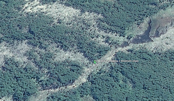 Tierra del Fuego Beaver Expansion 1960-70.kmz Tierra del Fuego Beaver Expansion 1960-70.kmz (7.59 KB)
|
|
Full Member
Cartographer
May 2015 - Oct 6, 2022 0:44:12 GMT
“ Fellow Royal Canadian Geographical Society „
|
Post by jeanthie on Jul 10, 2015 1:11:22 GMT
The expansion of beavers in Tierra del Fuego remains an amazing story.... the 25 pairs that created a population of over 100'000. Where did they come from?, what ecosystems formed their original natural habitat?On the website of the former Lamb Air, a letter is posted written by Tom Lamb in 1969 which details the story and the locations where the beaver were trapped. In one paragraph he describes the locations, which I have attached as KMZ file.  The image below gives an overview of the Saskatchewan Delta with locations of Devils Portage, Caroline lake and Moose Lake where the Lamb Family had a trading post.  White arrow points at beaver lodge.  |
|
Master Guide
March 2015 - Jan 20, 2022 4:27:51 GMT
|
Post by Hill on Jul 11, 2015 17:24:28 GMT
Reading this thread about beavers and beaver introductions I recalled mention of beaver introductions to California, specifically the San Bernardino Mountains of Southern California. HERE is a decades old article from the Los Angeles Times which took a dim view of the idea. HERE is a much more recent article about beavers in the desert bound Mojave River. The Southland Beaver blog has a lot of entries about these Southern California beavers and their survival in the face of the worst drought in 1200 years in the area. I went searching for beaver dams along the Mojave River using Google earth. Much imagery dates from 2014-2015 so it gives a current idea. I found the occasional deep pool in an otherwise dry river course, but can't say that any are proof of beaver activity. |
|
Full Member
Cartographer
May 2015 - Oct 6, 2022 0:44:12 GMT
“ Fellow Royal Canadian Geographical Society „
|
Post by jeanthie on Jul 12, 2015 3:01:02 GMT
I had a quick look at the Mojave River and found it a challenge as well. So I looked at your Southland Beaver Blog reference and tried the Santa Yenez river as a 'training exercise', since it does not have the extreme characteristics of the Mojave River. This is one of the areas I found: This is a combination of a look at 2013 and 2015 images. A number of dams are quite clear. Because of the high flow rates in part of the season, dams situations will vary from year to year.  Also Apple Maps shows a series of dams quite clearly;  santa yenez beaver.kmz santa yenez beaver.kmz (1.32 KB) |
|
Master Guide
March 2015 - Jan 20, 2022 4:27:51 GMT
|
Post by Hill on Jul 12, 2015 5:25:03 GMT
I'm glad you had good results with your search. It seems like you and Duane Nash of the blog have the same sense of appreciation for Castor canadensis. I'm quite fond of watching them too.
|
|
March 2015 - Jan 23, 2023 9:58:32 GMT
|
Post by Admin on Jul 14, 2015 16:51:47 GMT
Fantastic stuff, I have promoted this on G+ and FB. Cheers
|
|
Full Member
Cartographer
May 2015 - Oct 6, 2022 0:44:12 GMT
“ Fellow Royal Canadian Geographical Society „
|
Post by jeanthie on Jul 16, 2015 0:26:38 GMT
Thank you Hill and TheLedge for your comments, encouragements and links. (By the way, I still get interview request from global media about finding the longest beaver dam in the world with Google Earth in 2007; next month one with a Japanese production company visiting Canada to make a series of programs on World Heritage Sites)The Mojave River is quite a remarkable place for beaver and they are more abundant in some of the areas then I had expected. As you said Hill, the blog by Duane Nash provides great 'ground-truth' for a satellite analysis (southland beaver blogspot) and literally I followed his footsteps scanning the river system with GE. The results are included in the attached KMZ and the pictures below. Image 1: Overview of the Mojave River System and areas of beaver activity: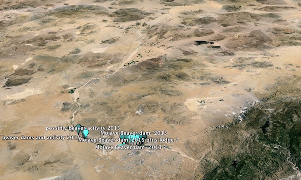 Image 2: Areas were beaver are concentrated Image 2: Areas were beaver are concentrated Because of the nature of the run-off in the Mojave River System, the beaver dam situations change significantly between years. Using the historical imagery, 2013 imagery provided the best year for 'mapping' beavers. Image 3: The image below is from 2015, place marks based on 2013 Image 4: The same area in 2013 shows a much wetter river system and larger beaver ponds upstream. Image 4: The same area in 2013 shows a much wetter river system and larger beaver ponds upstream.  Image 5: Even the 1994 air photos show that beavers were active then: Again the place marks are based on the 2013 imagery Image 5: Even the 1994 air photos show that beavers were active then: Again the place marks are based on the 2013 imagery |
|
Full Member
Cartographer
May 2015 - Oct 6, 2022 0:44:12 GMT
“ Fellow Royal Canadian Geographical Society „
|
Post by jeanthie on Jul 19, 2015 2:39:25 GMT
Tierra del Fuego: Expanding Beaver Area between 1970 and 2000+Earlier Tierra del Fuego posts 'mapped' the incredible expansion of the beaver population since 1945. The 'castor canadensis' originating from the Saskatchewan River Delta close to the community of Moose lake in Northern Manitoba, Canada thrived in the fascinating area of Tierra del Fuego. The attached KMZ provides 15 plus place marks giving a sample overview of the expansion of the types of dams and beaver habitat. These more recent invasion areas do not show the dominance and impact we have seen in the areas colonized in the first 20 years. In fact the beaver dams and activity areas originating in the last decades are far more difficult to find. It is actually quite amazing to see the distances they migrated in this short period of time. The selection of place marks by year is based on the map provided by C.B. Anderson, included in the previous post. Source: C.B. Anderson, 'Invaders in an Invasible Land', Principles of Conservation Biology 3rd Edition (2006) pp. 321-323 The original location of the release in 1945 in red, the expansion areas in light blue, yellow and white.  below an image of the most northerly beaver site I found on an GE image dated 2011. The Apple Maps image of a later date (2014 or 2015) shows a significant increase in dams in such a short period of time.  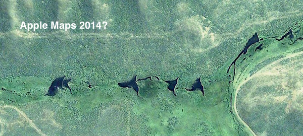 The image below shows a beaver system in the 1970-80 expansion area. 
|
|
Full Member
Cartographer
May 2015 - Oct 6, 2022 0:44:12 GMT
“ Fellow Royal Canadian Geographical Society „
|
Post by jeanthie on Jul 31, 2015 2:54:14 GMT
Invasive North American Beaver in Tierra del Fuego adapting to its new environment. The 25 pair of Castor Canadensis that were introduced by Tom Lamb in 1945 have reached a population of over 100'000 animals. The earlier post provide a good overview of their distribution and migration pattern by decade since 1945. The image below provides a synopsis. The purple markers show the area colonized in the first decade after introduction; the red markers show the second decade, the green the third decade. The yellow markers show areas colonized by the beaver in the 1990s, and the white markers fall in the expansion area of 2000s.  In one of my google searches I found the following map which shows the sampling sites to study the variations in Beaver 'DNA'. Since these sites correspond so closely with the purple, green and yellow markers I thought it would be interesting to study their work using the GE kml sites as reference.  The publication (pdf) INVASIVE NORTH AMERICAN BEAVER (Castor canadensis): THE DISTRIBUTIONOF MITOCHONDRIAL VARIATION ACROSS THE ARCHIPELAGO OF TIERRA DEL FUEGO by Mariana Fasanella, Sebastián Poljak and Marta S. Lizarralde Centro Regional de Estudios Genómicos, Universidad Nacional de La Plata, Av. Calchaquí Km23.5, 4th floor, CP 1888 Florencio Varela, Buenos Aires, Argentina [Corresponding author: Marta S. Lizarralde <mlizarralde@creg.org.ar> The three areas they study reflect the beaver area colonized in the first decade (1) the Fagano Lake Area, where they were released in 1945. Areas (2) is Tierra del Fuego National Park colonized about two decades later. Area (3) Isla Dawson was colonized again two decades later. The researchers identified seven unique D-loop haplotypes for the three areas. They are 'mapped' below.  They conclude that: "The complex network of aquatic habitats throughout the ATDF predicts that beavers might be moving freely throughout the region as one large panmictic population. However, our results indicate low but significant divergence among subpopulations (Fst = 0.104, p < 0.001). The manner in which animals use a landscape is determined both by their habitat requirements and social structure; thus, populations may exhibit spatial genetic structure even in the absence of physical barriers (Latch et al., 2008). In this work, we found significant divergence between Isla Dawson and the subpopulations of the Isla Grande (FLA and TNP; Fst = 0.124-0.166), suggesting a substantial geographic barrier to gene flow (perhaps coupled with a founder effect), presumably represented by the oceanic channel between Isla Grande and Isla Dawson (Hoffmann, 1985). On the other hand, the moderate Fst value between the subpopulations of the Isla Grande (TNP vs. FLA, Fst = 0.063) could be due to dispersal capabilities and large distances between the subpopulations (ca. 100 km). It is interesting to understand how the "genetic structure is linked first to the territorial organization of beavers (800 meters) and second to the migration of dispersers (subadults) constrained to travel far from the home-range of adults (5-8 km) to establish new colonies. Beavers become mature later than other rodents (2-3 years old), so subadults disperse and must settle far away to avoid costly aggressive interactions"
|
|
Full Member
Cartographer
May 2015 - Oct 6, 2022 0:44:12 GMT
“ Fellow Royal Canadian Geographical Society „
|
Post by jeanthie on Aug 5, 2015 0:03:29 GMT
As follow up to the genetic origin study of the Tierra del Fuego (TDF) beaver population in the previous post, I found another source with more specific review about the introduction of North American Beaver in Tierra Del Fuego. Alejandro G. Pietrek and Laura Fasola in their paper on ' Origin and history of the beaver introduction in South America' provide some interesting information. (Mastozool. neotrop. vol.21 no.2 Mendoza dic. 2014)The authors found that: " contrary to what has been widely assumed, only 20 beavers were released in a single introduction event in 1946". In this regard Lamb wrote in his letter "We only had three or four days of trapping when we got an inch of ice... I would watch beavers walk over our trap... however, we got 20 beaver when we would hardly get back to The Pas late October." The authors also speculate that the beaver population in northern Manitoba (i.e. the founders of the TDF population) probably had a mixed origin. An article published on April 9, 1936 in the Winnipeg Free Press and entitled "Six beaver taken north in restocking venture," states that "forward looking plans for the restocking with beaver on a large expanse of fur bearing territory around Moose Lake, will be advanced with the departure by air plane from Stevenson Field of six beaver from New York State." The airplane pilot was again Tom Lamb. In the 1930s and 1940s beavers had nearly disappeared from northern Manitoba due to over trapping. In addition to this, beaver were live trapped in other areas south of Manitoba and translocated north by truck and aircraft (Manitoba, the keystone province 1948; Malaher, 1984). These measures proved to be successful, and beaver catches rose from 6361 pelts in 1939-1940 to 51 318 beavers in 1963-64 (Smith, 1976). Although we did not find further documentation on restocking in Moose Lake, this was probably one of many translocation targets in northern Manitoba. The image below shows the locations where the ancestral TDF beavers were trapped. KML is from a previous post. The present conditions is significantly different from 1945-46 when they were trapped. The Hydro electric dam at Grand Rapids was build between 1960 and 1968 and the lower reaches of the delta including this area were affected by higher water levels. In the near future I will look at the Air Photos for this area before the flooding and the period between the 1930s and 50s to study the beaver status at that time.  Saskatcewan River Delta Manitoba-home of th....kmz Saskatcewan River Delta Manitoba-home of th....kmz (1.03 KB) |
|
Full Member
Cartographer
May 2015 - Oct 6, 2022 0:44:12 GMT
“ Fellow Royal Canadian Geographical Society „
|
Post by jeanthie on Apr 2, 2016 19:17:44 GMT
In their short paper on Beaver Wetlands Sharon T. Brown and Suzanne Fouty provide a nice synoptic overview of the Effect of Beavers on Wildlife and Water -linkTheir paper opens with a reference to the beaver dam described in the first post in this thread: They provide a succinct summary of the (beneficial) impact of beaver on wetlands and wildlife in the following table:  |
|
Full Member
Cartographer
May 2015 - Oct 6, 2022 0:44:12 GMT
“ Fellow Royal Canadian Geographical Society „
|
Post by jeanthie on Jan 31, 2017 2:45:36 GMT
It is always exiting as some new high resolution imagery comes on-line in Google Earth. In this case it is around Magellan Strait were I did earlier some explorations of beaver habitat. much of this imagery is from 2016. With this high resolution source (CNES/Astrium) dated 11-25-2016 it provides exceptional coverage for this area so frequently covered by clouds. The interesting part is that the beavers have crossed the Magellan Strait, swimming, I presume.
 Also Apple maps provide good additional high resolution coverage as the example below shows. The red arrow point to an area with some beaver dams, flooding and vegetation kill.  The same area on Google Earth ; red arrows point to beaver dams. 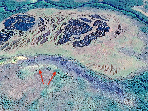 The various beaver dams are marked in the attached KMZ file, for those of you who would like to travel virtually to the famous and impressive Tierra de Fuego beaver expansion-after 2000.kmz (2.03 KB) |
|


