Master Guide
March 2015 - Jan 20, 2022 4:27:51 GMT
|
Post by Hill on Apr 25, 2015 23:04:58 GMT
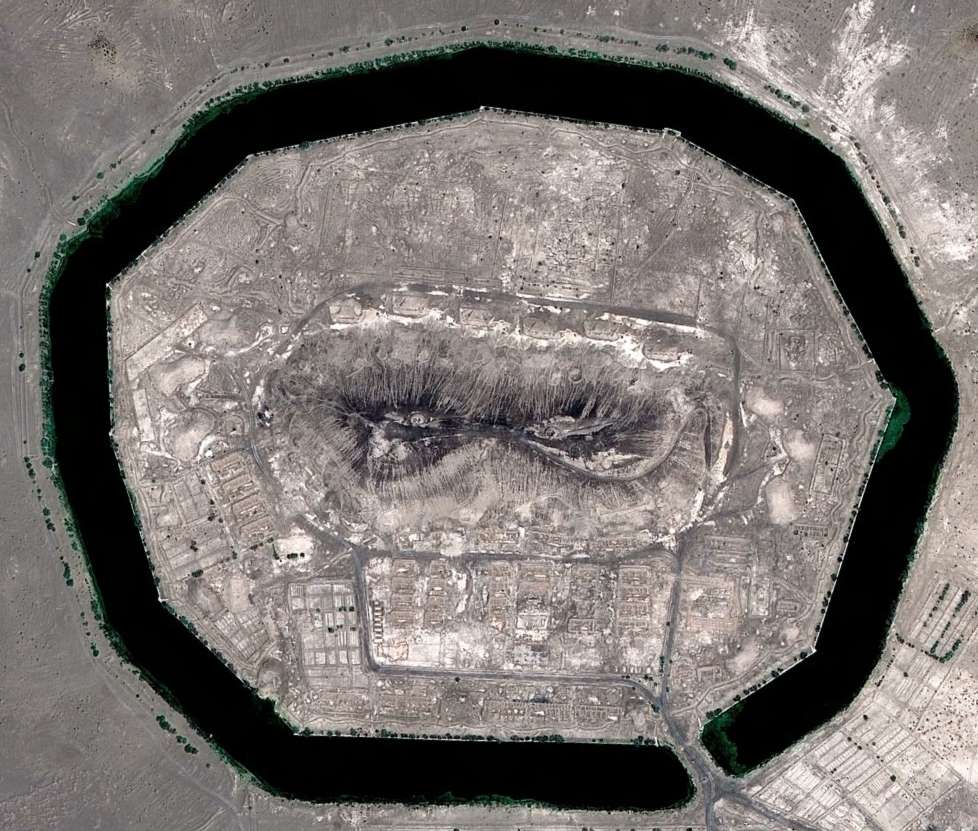
Back in the late 1960's China and the Soviet Union has a bit of a disagreement called the Sino-Soviet border conflict. During this time the two countries beefed up their defensive and offensive capabilities. It was not a huge war but lives were lost on both sides. Grand General Lin Biao led the Chinese military. One of his decisions was to build over a dozen moated fortresses which consisted of a central mound surrounded by level ground which was in turn surrounded by a water-filled moat. There were 8 or 9 built in the western Gobi Desert next to the Ruoshui River which flows north out of the Quilian Mountains and splits onto two main channels which travel across the Gobi to vanish in the sands at their northern end. The area at the time of construction was much lusher but has suffered from extreme desertification in recent decades. But there was a source of water near where the Murengaole River (West River) and Emunagaole River (East River) flow. The water table was high and the moats would just about fill themselves once built. Another half dozen, maybe more, were build in the eastern coastal plain. I've put together an annotated view of my interpretation of the design of these fortresses, some of which were abandoned before completion. You can find the original oGEC thread HERE. NOTE: Version 8.5 now has replaced version 8.4 of the attachment.
|
|
Cartographer
April 2015 - Apr 23, 2024 4:32:27 GMT
|
Post by washi on Apr 26, 2015 1:10:13 GMT
Liked it at the old place. Like it in the new. An incredible piece of analysis! I'd like to read a sentence or two about your source materials.
The central mounds in many cases are high enough so they show a bump in a tilted view. I found myself tilting at every fortress. While you're still fiddling with this, you might consider a tilted view for all of them.
|
|
Master Guide
March 2015 - Jan 20, 2022 4:27:51 GMT
|
Post by Hill on Apr 26, 2015 20:27:18 GMT
As I checked the oGEC thread I found only a few posters were able to provide information, including a few links. Unfortunately the links were to Chinese blogs which have by now changed ownership. There was some copied Chinese text, but forum software changes scrambled that. The best I have remaining from that thread are a couple of quotes from other participants: changeup wrote: " You know what? Actually you guess it right. They are fortresses with moats. However, they are not really that ancient. They were built around 1960's to 1970's, by Grand General Lin Biao, the chief of Chinese Millitary back then. The main purpose is to defend a possible Russian invasion. There are totally nine of them, each of which has adequate firearm and sufficient water supply. These constructions were abandoned in late 1970's and now some of them are developed into resorts. " When I found 8 of the 9 in the Gobi along the same river system, I assumed he was onto something. But I have never been able to verify the connection on the web. figgers wrote: "I have found another source that verified the fortresses were used to defend the Soviet army during the 60s to 70s, when USSR were hostile to China.
Ejina is the county where the fortresses are located.
See my brief translation to the section that related to the fortresses (or Er Hao Shan, "Mountain the second "It's a blog (in Chinese) from someone used to live near that area:(Blog link lost and chinese text scrambled by forum software change) (Title Translation: Ejina is always in my heart)
Brief Translation:
"Everyone knows the first mountain of China is Mt. Everest, but where is the second mountain of China? It's just in Ejina county. Thanks to the existence of "Moutain the second" during the period when Russia and China fell foul of each other, without it, the beautiful diversifolious poplar trees were gonna be pulled out and plundered by the Russians. It's just kidding. However, back to the age when "Mountain the second" being built, the construction work was really huge: Thousands of heavy trucks queued in Ejina, in and out, day and nights. The gas cans used for those trucks piled up was even higher than the mountain (must be viewed by the author). Now the kids living near the mountain must have grown up already. We wish "Mountain the second" can still bring luck to Ejina county as well as the old poplar trees." One of the fortresses is Erhaoshan or Mountain No.2 and it is slowly getting swallowed by the growth of Ejin, so their quotes, even unsubstantiated by web research, seem to carry some good weight.
Further information comes from this blog entry. The link to it has disappeared. Information was originally posted by figgers from the oGEC.    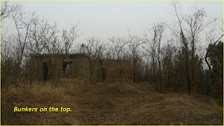 The above images are from the vicinity of the eastern fortress which I have named Zhengding, after the adjacent city. Zhengding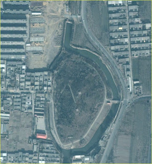 Here is the associated text: The majority of these fortress has been abandoned, only a few remain as a warehouse, and tourist attractions. Fact, more than the edge of the desert, the Beijing-Tianjin region is also distributed a number of similar military fortifications are these man-made mountain and above the Lin Biao and whimsical masterpiece in 1971 after the death of Lin Biao barrier Mountain Project "to stop. Of course, a different discourse, said that the artificial hill built by Mao Zedong's instructions, but asked the man-made mountain is indeed the Vice Chairman Lin.-------------------------------------------- According to Mao's instructions, China the army began to heap leading to the plains of Mongolia built just like a huge bunker Man-made mountain, in order to resist the Soviet tanks. These man-made mountain design Each 20 to 40 meters high, positive and 250 to 400 meters wide, the depth of $ 20 to $ 20 m astronomical sum of money voted into the stone and earth from the distance shipped, in the mountains to establish a steel and concrete fortifications. who have seen these mountain people, including former U.S. Secretary of Defense James Schlesinger (James R. Schlesinger,) thought that rely on this several solitary The artificial hill to block the Soviet tanks in-depth, wide front of attack impossible. later this works let the matter rest. From the "Mao: The Unknown Story" Su Yu know their suspicions and doubts are justified, inspection, he further feel metaphysics, idealism and extreme leftist ideas, have a great impact and destruction in the military field, reflected not only in the field of military thinking, but also fallen victim to the national defense construction national defense projects. He saw a region Engineering of man-made mountain, the seven man-made mountain, placed closer to a place away from the cutting-edge, away from the rear of relying on, the garrison direction is not right. He ever more worried about, the state has spent a large amount of capital, the majority of commanders and fighters of painstaking labor, but this artificial mountain project in terms of strategic or tactical point of view, and placement are wrong. The idea of the formation of these errors tend to come from above. He believes that metaphysics, idealism is the serious hazards of the military and national defense construction, should arouse the central attaches great importance. From Su Yu BiographyIn May 1967, the Corps of Engineers hosted in Beijing convened heap Hill Engineering Conference, study and formulate the "man-made mountain engineering tactics technical requirements (draft)", according to this "request", the artificial mountain is to defend the coastal mountains, to defend the plain transport hub and strategic points, to defend the backbone of the fortifications of the big cities, mainly for long-range artillery trial, and every mountain tube of 40-50 km. Therefore, the distance between the two artificial hill can not be too close to the cross Lee gunfire. Construction of connection between mountains fortifications, configuration, small and medium artillery. Artificial mountain and connected fortifications rely on each other to connect the fortifications to cover man-made mountain. The artificial hill also assume the role of artillery observation and command posts, once the enemy crossed, but also as an artillery fortress to stay behind enemy lines. An artificial hill to configure a garrison camp, including a long-range artillery battery (4-6 guns); 1-2 garrison and even (with light anti-tank weapons, antiaircraft weapons, and other infantry weapons); wartime enter an artillery command structure.The total strength of about 300-500 people. Artificial mountain Yamagata diamond unimodal or bimodal oval at altitudes of 20-40 m, the front width of 250-400 m, 120-220 m depth. Tunnel axis length of 600-1000 m, Keng Daokou 6-10. The fortifications requirements to 500-1000 pounds of blasting cartridge able to withstand a direct hit. Internal requirements of the natural ventilation, electricity and water supply.That is all I have to go on for now after about 10 years of searching, and none of the image or text links survive. |
|
Master Guide
March 2015 - Jan 20, 2022 4:27:51 GMT
|
Post by Hill on Apr 27, 2015 0:26:20 GMT
Liked it at the old place. Like it in the new. An incredible piece of analysis! I'd like to read a sentence or two about your source materials. The central mounds in many cases are high enough so they show a bump in a tilted view. I found myself tilting at every fortress. While you're still fiddling with this, you might consider a tilted view for all of them. I do plan to measure the fortresses. I find the "show elevation profile" very helpful for this.  |
|